from: Maps
Anton ROESSLER. The Latest Map of the State of Texas...1874
Anton ROESSLER. The Latest Map of the State of Texas...1874
Couldn't load pickup availability
ROESSLER, Anton (1826-1893)
The Latest Map of the State of Texas
Lithograph
1874
40” x 45 ¼” sheet, 51 ½” x 57” framed.
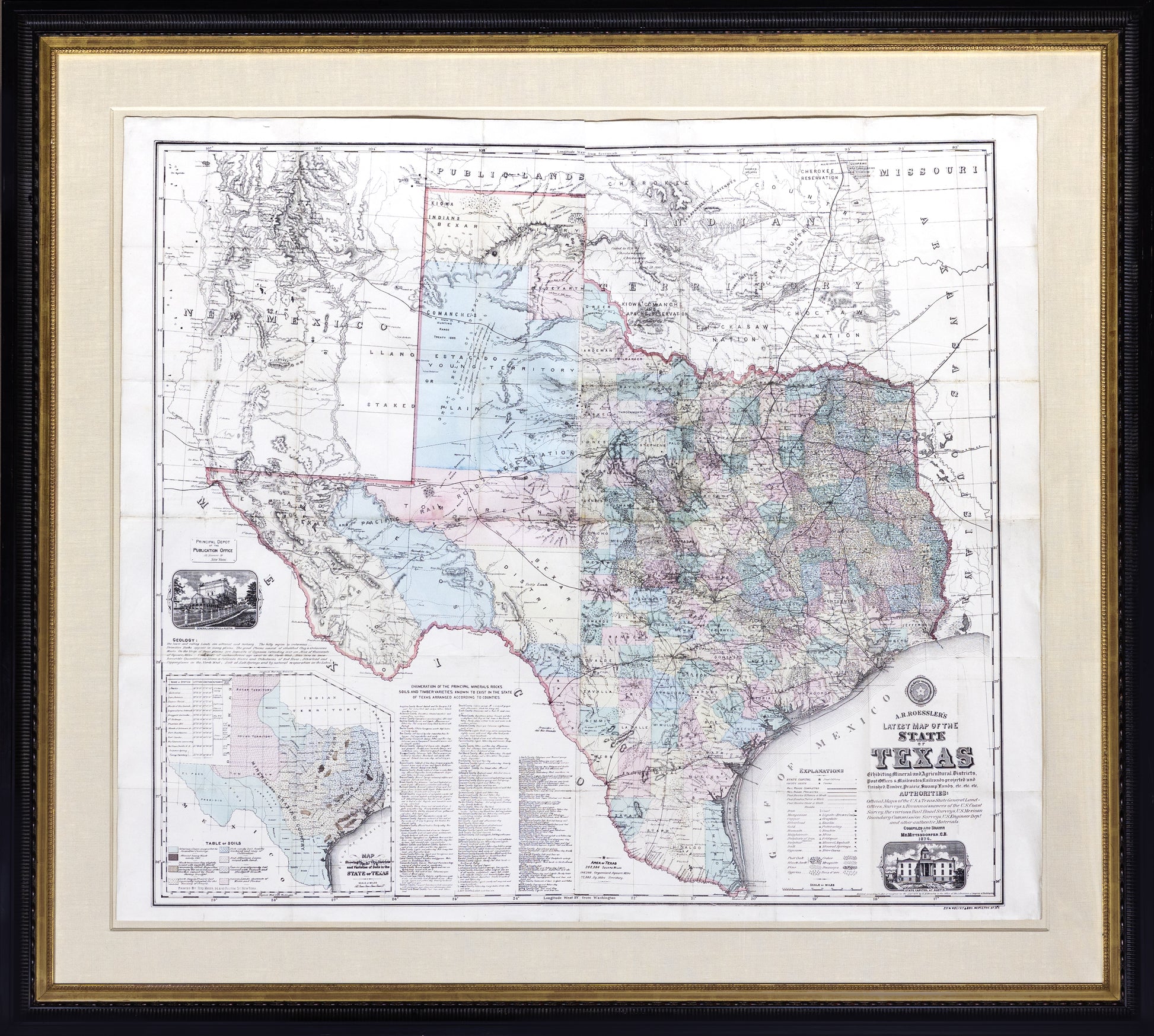
In 1874 Roessler wrote: "Texas is, or will be, the wealthiest state in the Union, possessing as she does great agricultural capabilities, all the varieties of soils, minerals and useful rocks known to exist in the world." His extraordinarily detailed large scale map was designed to demonstrate the truth of his declaration. After De Cordova’s map, perhaps the most attractive map of the State of Texas.
View the roots of texas collection
THE SCARCE FIRST ISSUE OF ROESSLER'S LARGE-FORMAT MAP OF TEXAS.
Anton R. Roessler (1826-1893), cartographer and geologist, served in these roles for the Shumard Survey, the first thorough geological and agricultural survey of Texas. His maps are the only printed maps preserving the results of that survey which was scrapped during the Civil War. Indeed Roessler was accused of stealing the Shumard survey data for private use in his own real estate and mining ventures, and their use in his maps make them the most reliable contemporary record of agricultural and mineral wealth in the state.
In the decades after the civil war, Texas enjoyed spectacular growth as settlers from back east poured in and the railroads opened many areas for more activity. Anton Roessler, a Hungarian born Texan and secretary of the Texas Land & Immigration Company was one of the best cartographers in Texas in the 1860’s and 1870’s. His maps were considered the best then, and are prized today, for their wealth of information on geology, soil conditions and agricultural prospects. This map includes details on deposits of over a score of minerals – even broken down county by county. For the benefit of settlers, the types of soils to be found such as “loam unequaled for its excellent pasturage” and “prairie soil especially adapted for the raising of cereals” are marked as are the varieties and locations of various trees, from swamps to Post Oaks and Mesquite.
All of this is overlaid on a detailed map reflecting the political and commercial situation of the day – completed and projected rail lines are recorded, as are the wagon roads offering mail service, even broken down by whether the frequency was once, twice or three times a week. The Texas & Pacific Rail Road Reservation spreads across west Texas in anticipation of the completion of the transcontinental railroad. The Panhandle includes the Hunting Range of the Comanches and Wegefarth and Greer counties, the former disbanded and the latter given to Oklahoma after a federal dispute over the true boundary of Texas. Vignettes of the General Land Office at Austin and original State Capitol building, destroyed by fire in 1881, are included. Texas is shown as having 268,684 square miles, of which only 196,299 had been organized.
