from: Maps
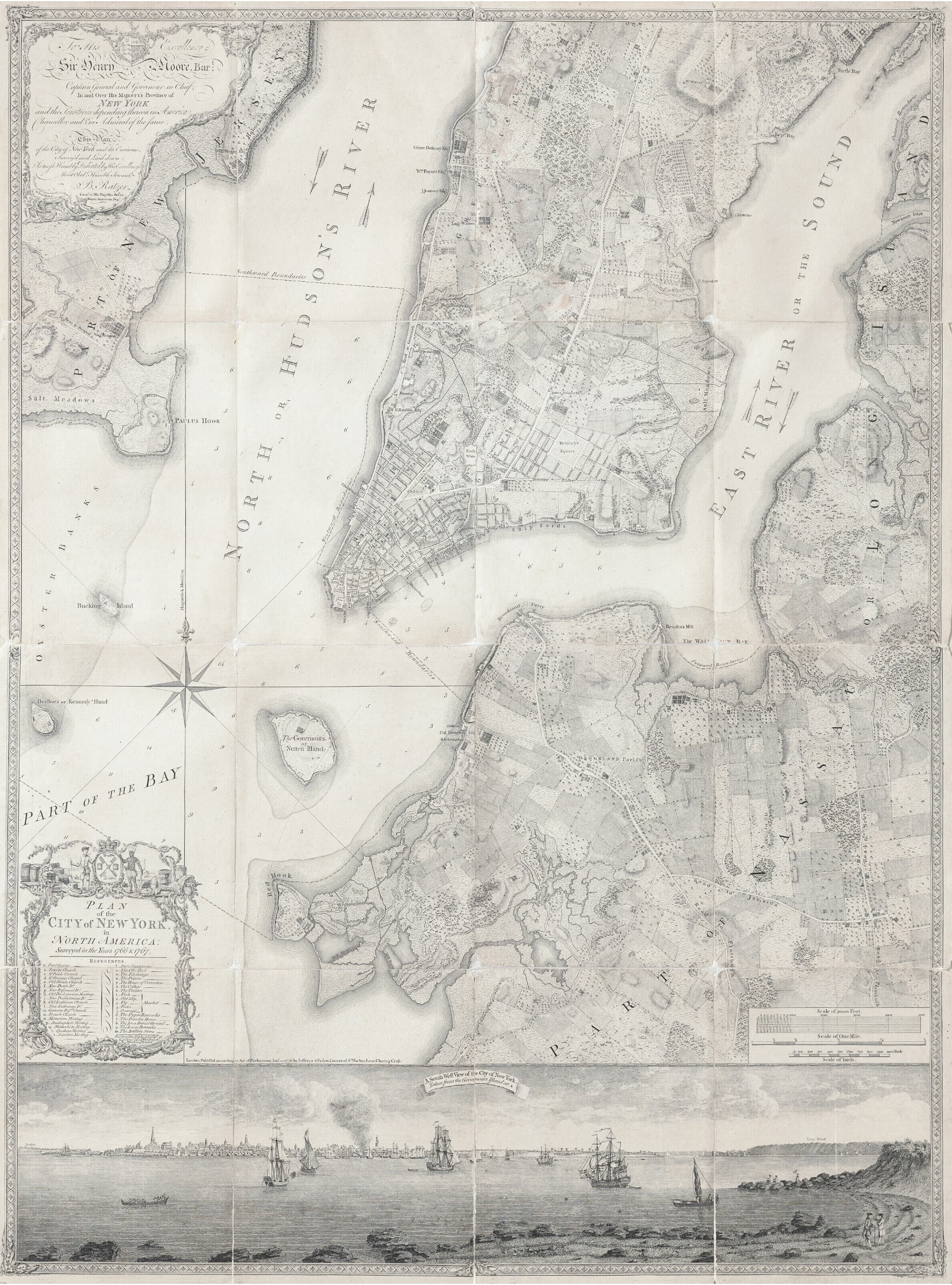
RATZER, BERNARD ( fl. 1756-1777) Plan of the City of New York in North America, surveyed in the years 1766 & 1767.
RATZER, BERNARD ( fl. 1756-1777) Plan of the City of New York in North America, surveyed in the years 1766 & 1767.
Couldn't load pickup availability
RATZER, BERNARD ( fl. 1756-1777)
Plan of the City of New York in North America, surveyed in the years 1766 & 1767.
Second State (imprint of Faden & Jeffreys above the view)
London: Faden & Jeffreys, 1776
Engraved folding map dissected into sixteen panels each 12 x 9 inches, total dimensions 48 5/8 x 35 3/4 inches, backed on linen, with board covers.
When revolution came to North America, the British needed superior maps of the seats of war. None were better than Ratzer’s masterpiece of engineering, rococo design and topographical detail. The most important map of New York published in the 18th century.
The Greatest 18th Century American City Plan and the Most Important Colonial Map of New York City & Environs.
An unparalleled map for its detail and grandeur, Bernard Ratzer's map of the New York City area is without question the most decorative and sought after 18th Century plan of New York City among collectors and an historic artifact of the highest order.
This example, issued in 1776, the year New York was taken by force by the British Army from the American Colonists at the outset of the American Revolution, has become an icon among American collectors, offering by far the best contemporary view of New York at the time of its fall to the British in late 1776. In fact, this was the primary map utilized by the British during the Battle of Brooklyn in August 1776 and subsequent capture of Manhattan several months later, with British Division Commander General Hugh Percy's redlined and annotated copy of this map currently on display in the collection of the Brooklyn Historical Society.
Bernard Ratzer's map was by far the most accurate published plan of New York City and its environs at this critical time in history. The map is based on the surveys undertaken at the direction of Sir Henry Moore, who authorized mapping efforts in response to the Stamp Act Riots of 1765. He and other British leaders feared that the city might soon become a battleground -- a fear they no doubt carried over from the barely-concluded French and Indian War. Needing a more detailed accounting of New York's layout, the British authorities commissioned Ratzer to survey and construct a map the city, which was drawn in 1766.
Ratzer's initial survey has come to be known as the "Ratzen plan" (1769), which focused exclusively on lower Manhattan and gained its moniker from a misspelling of Ratzer's name in the title. The Ratzen plan was a significant improvement over the maps of New York City that had preceded it.
In 1767, Ratzer began a more comprehensive survey of the areas surrounding the city. The result was his remarkable map of New York City and environs, first issued in 1770. This larger map is typically called the "Ratzer map." Cohen & Augustyn state that the Ratzer Map is perhaps the finest for an American city produced in the eighteenth century. The "geographical precision combined with highly artistic engraving was unsurpassed in the urban cartography of its day." As noted by the famed 19th Century Bookseller Henry Stevens in his monumental Rare Americana catalog 19:
This Plan, a very fine specimen of the engraver's art, is on a scale of 6 inches to the mile, with great detail, the whole enclosed in an artistic border about half an inch wide. The Title and Dedication are in 2 separate ornamental cartouches . . . In addition to the very numerous street names, &c. to be found in the body of the Plan, there are no less than 35 references listed in the lower half of the Title cartouche.
This Plan is of extreme rarity and is greatly sought after on account of the very fine View of the City of New York which occupies its whole width at the foot. The view measuring 34 x 7 inches is entitled, "A South West View of the City of New York taken from the Governour's Island at *."
This Plan is referred to in "Stokes Iconography of Manhattan Island, New York, 1915," p. 341, as follows:
"This is one of the most beautiful, important and accurate early plans of New York. The view is unusual, very attractive and beautifully executed." Mr. Stokes concludes his article by saying "The Ratzen and Ratzer Plans are the most accurate and reliable which we have of New York at this period and are even today much used in searching titles."
The Detail of the Ratzer Plan
Ratzer's map was completed to a level of detail unparalleled in a study of an American city; the work is fitting of an official map of a major English city.
Manhattan above Duane Street (unnamed here) is almost entirely given over to country estates and common land, with the exception of a still-developing area around the Bowery, west of Delancy Square. The country estates are labeled with the names of approximately 20 landowners, which will be familiar to students of New York history (Stuyvesant, Bayard, Delancy, Beekman, Harrison, Murray, Watts, Duane, Tiebout, etc.). The Bowery (here "Bowry") leads up through the center of the island before splitting into Bloomingdale Road and the "Road to King's bridge or Boston".
A successful effort has been made to render pictorially elevation, fields, marshes, salt meadows, and gardens around the city. The general effect is comprehensive enough to transport one back in time.
The view at the bottom of the map was drawn by Lieutenant Thomas Davies, it shows lower Manhattan from Governor's Island, with Brooklyn Heights at the right. Some of Davies's original watercolors survive to this day. The Old Print Shop in New York City offered for sale the original Davies watercolor on which this view is based in the middle of the 20th century.
The Ratzer Map and the American Revolution: The Battle of Brooklyn and the Capture of Manhattan
After the British defeat at the Siege of Boston, attention quickly shifted southward to New York City and its impressive harbor. General George Washington began deploying troops to the city in anticipation of a British attempt to capture it, and General William Howe confirmed Washington's suspicions when he landed a large British force on Staten Island.
With this pivot in the conflict, the Ratzer plan, which William Faden reissued in January of 1776 (this issue), was quickly shipped across the Atlantic for use in the field.
On the evening of August 26, Generals Howe, Clinton, Cornwallis, and Percy began a daring flanking maneuver to encircle American troops defending Guan Heights, in Brooklyn. Their aim was to destroy Washington's army there and move on to Manhattan. While a Hessian detachment of 4000 troops attacked frontally, distracting the American defenders, Howe attacked from the flank. The stratagem was incredibly successful and those Patriots not killed or captured were quickly forced back to the defenses of Brooklyn Heights. The entire scope of the battle can be seen on his Ratzer map.
The engagement was a resounding defeat for Washington, and on top of it, he had been unable to accomplish a complete withdrawal from the field; Washington was backed into Brooklyn Heights and corralled against the East River. The British forces had closed in on all sides and were digging in for a siege. If Washington and his troops were captured, the Revolution would almost surely be finished.
Fortuitously for the Americans, Washington was not destined for that fate. In one of the major missteps of the war, General Howe failed to press his advantage; as he prepared for a slow and deliberate attack on Brooklyn Heights, Washington and all of the American forces boarded boats and escaped to Manhattan by way of Brooklyn Ferry (here, "Brookland Ferry"), under the cover of night. With this brilliant evasive move, Washington saved his troops and himself and succeeded in prolonging the war.
The story of Washington's escape from Brooklyn can be seen on the map; here is shown the nascent village of Brooklyn, the docks from which the Americans embarked, and the Manhattan wharves where they landed and regrouped. With this map we can understand that event as General Howe understood it, watching victory slip through his fingers and across the East River.
After Washington's escape, Howe again acted slowly, sending the captured American General John Sullivan to deliver a message to the Continental Congress, ostensibly in an attempt to bring the war to an end through diplomacy.
During this time, Washington, who had previously been ordered by Congress to hold New York City, was concerned that he might have escaped one trap for another since the army was still vulnerable to being surrounded on Manhattan. To keep his escape routes open to the north, he placed 5,000 troops in the city (which, as seen on the map, only occupied the lower portion of Manhattan), and took the rest of the army to Harlem Heights. In the first recorded use of a submarine in warfare, he also attempted a novel attack on the Royal Navy, launching the Turtle in a failed attempt to sink the HMS Eagle, Admiral Howe's flagship.
On September 15, General Howe landed about 12,000 men on lower Manhattan, quickly taking control of New York City. The Americans withdrew to Harlem, where they skirmished the next day, but held their ground. Rather than attempting to dislodge Washington from his strong position a second time, Howe again opted for a flanking maneuver. Landing troops with some opposition in October in Westchester County, he sought once again to encircle Washington. To defend against this move, Washington withdrew most of his army to White Plains, where after a short battle on October 28 he retreated further north. This isolated the remaining Continental Army troops in upper Manhattan, so Howe returned to Manhattan and captured Fort Washington in mid-November, taking almost 3,000 prisoners.
Throughout the capture of New York City, the Ratzer plan was closely consulted by English commanders; for instance, as noted above, a copy of the Ratzer map annotated for Lord Percy during the campaign is held by the Brooklyn Historical Society.
