from: June 2025 1
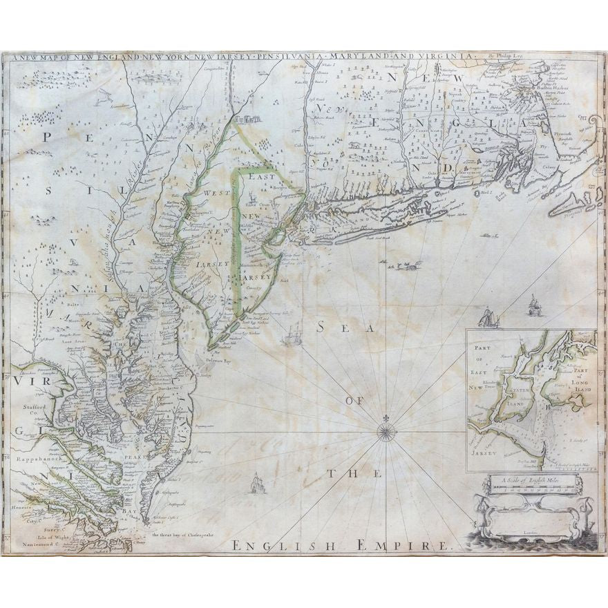
Philip Lea's New Map of New England, New York, New Jarsey, Pensilvania, Maryland and Virginia
Philip Lea's New Map of New England, New York, New Jarsey, Pensilvania, Maryland and Virginia
Couldn't load pickup availability
LEA, Philip (c. 1660 – 1700).
A New Map of New England, New York, New Jarsey, Pensilvania, Maryland and Virginia by Philip Lea.
Engraved map with original hand color in part.
London: 1698. (Third State, - Lea Imprint & Che Sea Peake Bay is now named).
17 1/2" x 21 1/8" sheet, 27" x 31" framed.
Thornton, Morden & Lea's map is the first obtainable state of the finest general map of England's American colonies to date. The map is one of the earliest to include Augustine Herrman's cartography for Virginia and Maryland. To the North it includes one of the earliest depictions of the Pennsylvania colony (est. 1681), the first printed chart of New York Harbor, and significant additions to the cartography of New England.
The map shows the English colonies from Cape Ann in Massachusetts to Cape Henry at the mouth of Chesapeake Bay. The map extends as far north as the tributaries of the Hudson, and in the southwest it shows the Delaware and Susquehannah Rivers and as far west as the tributaries of the Potomac and Rapahannock. Augustyn and Cohen note the importance of the inset:
To the ambitious person, the map would have presented an enticing vista: it displays a loose federation of colonies, between and beyond which there appears to be ample unclaimed land. It creates an image of an area comfortingly linked by civilization but still containing much open territory.
The geography of Virginia, Maryland, Pennsylvania and New Jersey derives from the Thornton-Greene Mapp of Virginia Mary=land, New Jarsey, New=York, & New England (ca 1678), whose depiction of the region is in turn based largely on Augustine Herrman's Virginia and Maryland (1673). The Thornton-Morden-Lea departs from these prototypes, however, in showing the new colony of Pennsylvania and incorporating changes to the course of the Delaware and place names along its banks.
New York and southern New England are drawn from the Thornton-Greene map, which in turn draws on John Seller's Mapp of New England (1676). Here as well Thornton, Morden and Lea have departed substantially from the prototypes: Long Island's barrier beaches are shown for the first time on a printed map and numerous place names are introduced along the Connecticut coast and on Cape Cod; the boundaries between Massachusetts, Plymouth and Connecticut colonies are drawn; and several roads are shown.
The inset of New York Harbor is also of great import, being the first separate printed chart of the area. Based on a 1683 survey conducted by Philip Wells for William Penn and the other proprietors of West New Jersey, it is far more accurate than earlier work. The inset shows particularly well the shoals that confine shipping to a single deep-water entrance around Sandy Hook.
Remarkably, the map was almost certainly originally issued as part of a 4-sheet wall map, of which only one example survives. As determined by McCorkle and Taliaferro:
The map is actually a separately-issued section of a multi-sheet wall map entitled A New Map of the English Empire in the Continent of America (1685). This ambitious project was a collaborative venture between three of London's leading map publishers, but it resulted in a map that was far too expensive to succeed. The Thornton-Morden-Lea wall map survives today only in one ... copy in the Bibliotheque National in Paris.
But the map's publishers had anticipated that the wall map would be financially risky, so they included all of the English colonies except for Carolina on one sheet, and this sheet was designed to that it could be sold separately. It was given its own secondary title, A New Map of New England New York New Jarsey Pennsylvania Maryland and Virginia, which could be trimmed off when the sheet was used for the wall map. (Richard B. Arkway and Cohen & Taliaferro, Catalogue 62, item #8).
