from: Maps
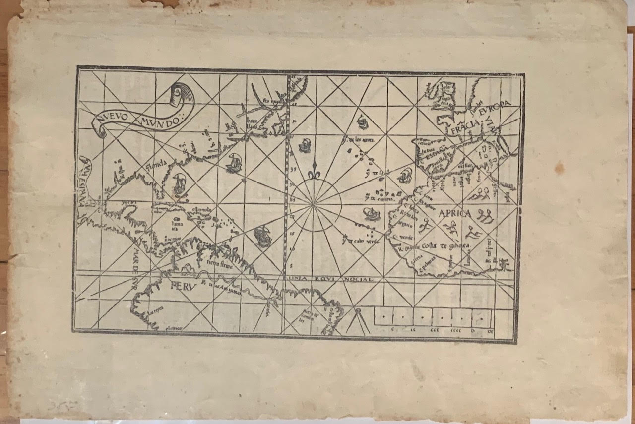
Pedro de Medina (1493-1567) Nuevo Mundo From: Arte de Navegar Valladolid, 1545
Pedro de Medina (1493-1567) Nuevo Mundo From: Arte de Navegar Valladolid, 1545
Couldn't load pickup availability
Pedro de Medina (1493-1567)
Nuevo Mundo
From: Arte de Navegar
Valladolid, 1545
Woodblock Print
Paper Size:5 3/4” x 9 9/16”
“Among all arts navigation is the most accomplished one, for not only does it draw from each of them, it also contains, by itself, its most important disciplines: arithmetic, geometry, & astrology.”
The prologue of Pedro de Medina’s groundbreaking “Arte de Navegar” (1545) reveals the work’s Medieval heritage, as the quadrivium - the university curriculum of arts - unmistakably locates navigation within its mathematical system of knowledge. Navigation, as Pedro de Medina suggests, builds on the illustration of the world guided by principles of certainty. At the same time, he refers to Ptolemy and proves himself at a transitional moment of cartography and the Renaissance in general. The present map of the New World is thus a particularly rare and precious testament to both the socio-political and artistic history of the 16th century.
Taken from the third book of his monumental treatise on navigation, the present map of the New World or “Nuevo Mundo” is the first known depiction of the so-called Tordesillas Meridian bisecting the Americas West of the Azores and Cape Verde Islands. The Treaty of Tordesillas was based on the bull “Inter Caetera” (1493) in which the Aragonese Alexander VI decreed a Papal Demarcation Line in 1493; it was meant to divide the trading and colonizing rights of the New World between the Spanish Crown and Portugal.
The map is also remarkable for its geographical accuracy. Pedro de Medina had travelled with Hernando Cortéz and, upon his return to Spain, was responsible for debriefing ship crews. He thus relied on authentic source material and the mention of Florida is one of the earliest in contemporary map publishing. Similarly, “Nuevo Mundo” is the first map to include the Rio Spiritu Santo in Texas.
Maybe its most astonishing feature are the ships grouped around the central compass rose. As a motive they derive from early cartographers’ depiction of vessels and sea monsters to characterize the oceans. Upon closer inspection, however, it appears that they are organized according to what art historians know as simultaneity. The trading ship, departing from Spain, follows the circular movement of the Gulf Stream to reach the Americas; it then takes a Northern route back to Europe. Pedro de Medina utilizes narrative strategies commonly associated with painting to prove a surprising interest in the Stream and its impact on travel routes. The author thus illustrates the practical qualities of sea charts as presented at the beginning of Chapter 7 on the map’s verso.
The verso includes a woodblock printed diagram and lists the most important elements of sea charts, including the compass rose and rhumblines. “Nuevo Mundo” can thus be seen as an ideal chart which, in addition to its historical and cartographic merits, introduces a subtle use of imagery and narrative strategies commonly associated with fine arts. Its main purpose, however, remains that of navigational practicality.
The present map represents the first state with 16 rhumblines. It can be dated 1545, whereas at least two other states are known from editions dating 1548 and 1552 respectively. It is a single-sheet map in excellent condition. Foxing is very limited and clean tears along the margins minimal. The press crease is visible in the gutter margin.