
from: Maps
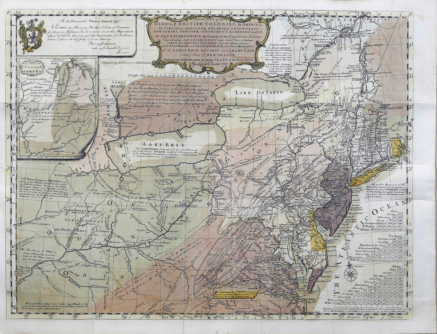
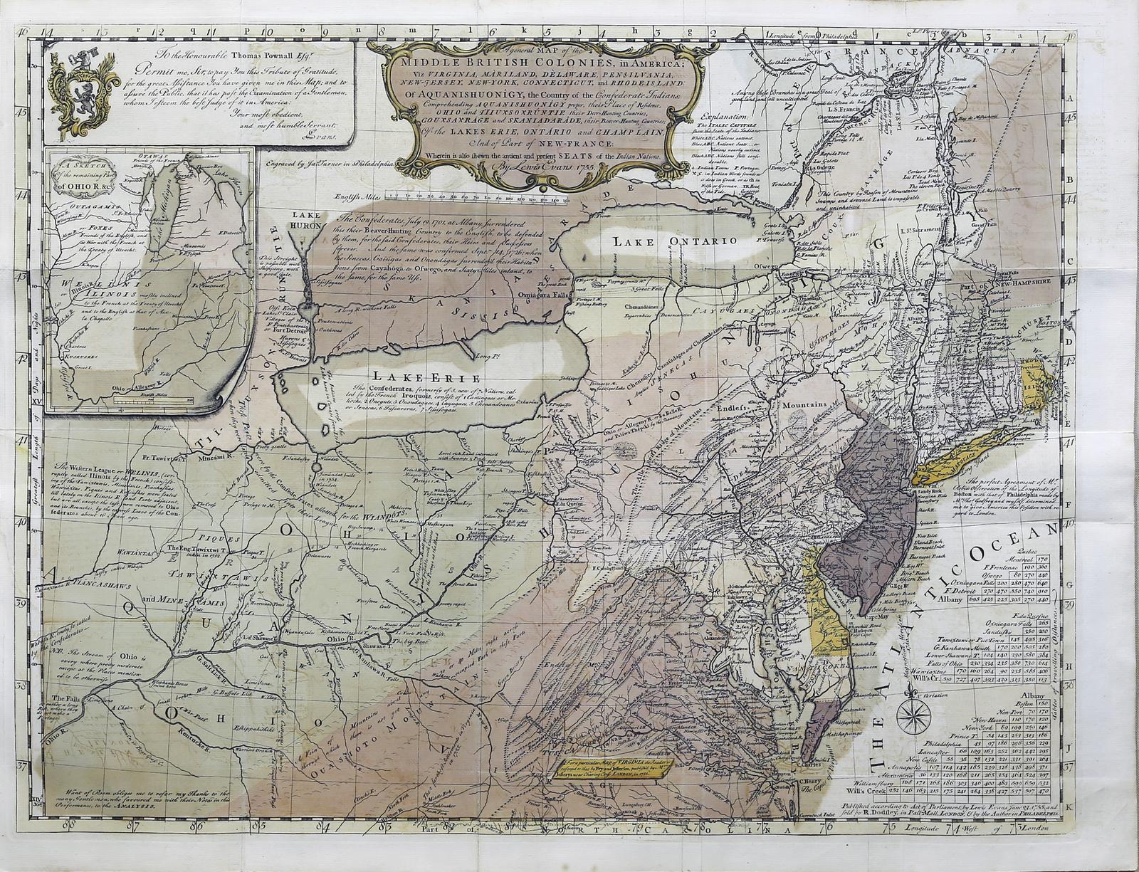
Lewis Evans. Map of the Middle British Colonies. 1755.
Lewis Evans. Map of the Middle British Colonies. 1755.
Regular price
$ 275,000.00 USD
Regular price
Sale price
$ 275,000.00 USD
Unit price
per
Couldn't load pickup availability
EVANS, Lewis (1700-1756).
A General Map of the Middle British Colonies, in America; viz Virginia, Mariland, Delaware Pensilvania, New-Jersey New-York, Connecticut, and Rhode Island of Aquanishuonigy, the Country of the Confederate Indians Comprehending Aquanishuonigy Proper, their Place of Residence, Ohio and Tiiuxsoxruntie Their Deer-Hunting Countries, Couxsaxrage and Skanidarade, Their Beaver-Hunting Countries; Of the Lakes Erie, Ontario and Champlain, and Part of New-France Wherein is Also Shewn the Antient and Present Seats of the Indian Nations.
Engraved map with original hand color in full.
Philadelphia, 1755 (First State).
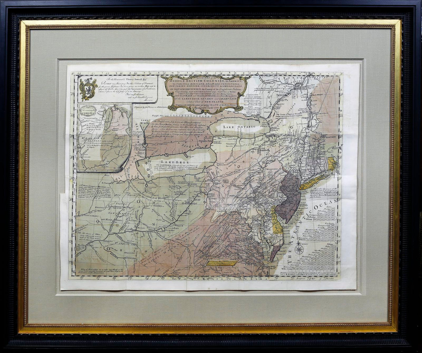
21" x 27 3/4" sheet, 33" x 40" framed.
With Accompanying text volume.
"One of the most important maps published in America before Independence." - Schwartz and Ehrenberg
Spectacular Full Original Color at the Highest Level Possible
John Rennie Short description: "In 1750 Lewis Evans was commissioned by the Philadelphia Assembly to survey and map the region. It was a tense time because of rival British and French claims. His work had to be done in secret and it took Evans four years to complete his task. The map first appeared in 1755 to illustrate an essay printed by Benjamin Franklin.
The result is a map that rivals John Mitchell's great map of British America. It had similar geopolitical goals to advance permanent British settlements in the border areas, to uphold the legitimacy of British claims and to identity the disposition of Native American tribes as likely allies or possible enemies in the coming conflict with the French.
The Evans map illustrates the eastern seaboard settlements of the British but also the French settlements in new France and the Native American settlements throughout the Ohio Valley. It is a map not only of the present but also the future. It is ripe with promise. Valuable mineral resources and fertile land are all presented almost in the form of enticement for settlement, investment and speculation. It was an enticement to move westwards to claim exploit the resources and occupy the land.
As a cartographic claim to a contested area it is part of the cartographic war between Britain and France that later would later turn into the actual war of 1756-1763."
Lewis Evans' A General Map of the Middle British Colonies, along with the maps of Henry Popple (1733) and John Mitchell (1755), is considered the most important and influential American map of the 18th century. Printed by Benjamin Franklin in Philadelphia in 1755, the Evans map is the only of the three to have been published in America by an American. Both Evans' and Mitchell's maps were intended to spur western expansion into the Trans-Allegheny, Ohio Valley, and regions westward, and in response to French encroachments.
Evans' map provided the best early depiction of the Ohio Country while documenting competing British, French, and Native American claims in a region destined to be the flashpoint of the French and Indian War. In this regard, it is of particular note for treating the Iroquois Confederacy as a geopolitical power in its own right, with its own internal political structure, territory (here known as "Aquanishuonigy") and diplomatic interests.
The map is also the first regional map of Colonies widely utilized for land speculation in the American frontier. Published at a time when British Colonial western expansion was still limited by the claims of the French, Evans' map provided the best available information concerning the lands at the Western limits of the British Colonies that were available to investors and speculators.
One of the Evans map's great contributions was its original depictions of the natural resources of the interior. In particular, it is the earliest mapping of petroleum and coal resources in this country. It is the first document to mention oil at the birthplace of the oil industry, western Pennsylvania.
Pritchard and Taliaferro describe Evans as "the best geographer working in the English colonies in the mid-eighteenth century. A dedicated scientist, he exchanged scholarly information with Peter Collinson, Benjamin Franklin, colonial administrator Thomas Pownall, New York mathematician and mapmaker Cadwallader Colden, and others." (Degrees of Latitude, p. 172)
Evans' map was published with his Analysis of a General Map of the Middle British Colonies, an essay describing the map's sources and explaining its geopolitical significance. This essay is of great importance when understanding the lengths to which Evans went in compiling the most accurate and up-to-date information in his map.
Evans great map of 1755 follows from a more restricted map, his Map of Pennsylvania, New Jersey, New York, And the Three Delaware Counties (Philadelphia, 1749), which included the cartographic results of his 1743 expedition, in addition to those of John Bartram and Indian agent Conrad Weiser. In 1755, he considerably expanded the depth and breadth of his mapping.
Wheat & Brun: Maps And Charts Published In America Before 1800, 298 (ill.); Stevens: Lewis Evans, II, (pl. II); Schwartz & Ehrenberg: Mapping Of America, p.168 (ill.); Cumming: Exploration Of North America, p. 65 (ill.); The World Explored, 55; McCorkle: New England In Early Printed Maps, 755.15 (ill.); Pritchard & Taliaferro, Degrees of Latitude, p. 172; Klinefelter, "Lewis Evans and His Maps", Transactions of the American Philosophical Society; Eavenson, "Who Made the 'Trader's Map'", The Pennsylvania Magazine of History and Biography, p. 420-438.
View full details
A General Map of the Middle British Colonies, in America; viz Virginia, Mariland, Delaware Pensilvania, New-Jersey New-York, Connecticut, and Rhode Island of Aquanishuonigy, the Country of the Confederate Indians Comprehending Aquanishuonigy Proper, their Place of Residence, Ohio and Tiiuxsoxruntie Their Deer-Hunting Countries, Couxsaxrage and Skanidarade, Their Beaver-Hunting Countries; Of the Lakes Erie, Ontario and Champlain, and Part of New-France Wherein is Also Shewn the Antient and Present Seats of the Indian Nations.
Engraved map with original hand color in full.
Philadelphia, 1755 (First State).
21" x 27 3/4" sheet, 33" x 40" framed.
With Accompanying text volume.
"One of the most important maps published in America before Independence." - Schwartz and Ehrenberg
Spectacular Full Original Color at the Highest Level Possible
John Rennie Short description: "In 1750 Lewis Evans was commissioned by the Philadelphia Assembly to survey and map the region. It was a tense time because of rival British and French claims. His work had to be done in secret and it took Evans four years to complete his task. The map first appeared in 1755 to illustrate an essay printed by Benjamin Franklin.
The result is a map that rivals John Mitchell's great map of British America. It had similar geopolitical goals to advance permanent British settlements in the border areas, to uphold the legitimacy of British claims and to identity the disposition of Native American tribes as likely allies or possible enemies in the coming conflict with the French.
The Evans map illustrates the eastern seaboard settlements of the British but also the French settlements in new France and the Native American settlements throughout the Ohio Valley. It is a map not only of the present but also the future. It is ripe with promise. Valuable mineral resources and fertile land are all presented almost in the form of enticement for settlement, investment and speculation. It was an enticement to move westwards to claim exploit the resources and occupy the land.
As a cartographic claim to a contested area it is part of the cartographic war between Britain and France that later would later turn into the actual war of 1756-1763."
Lewis Evans' A General Map of the Middle British Colonies, along with the maps of Henry Popple (1733) and John Mitchell (1755), is considered the most important and influential American map of the 18th century. Printed by Benjamin Franklin in Philadelphia in 1755, the Evans map is the only of the three to have been published in America by an American. Both Evans' and Mitchell's maps were intended to spur western expansion into the Trans-Allegheny, Ohio Valley, and regions westward, and in response to French encroachments.
Evans' map provided the best early depiction of the Ohio Country while documenting competing British, French, and Native American claims in a region destined to be the flashpoint of the French and Indian War. In this regard, it is of particular note for treating the Iroquois Confederacy as a geopolitical power in its own right, with its own internal political structure, territory (here known as "Aquanishuonigy") and diplomatic interests.
The map is also the first regional map of Colonies widely utilized for land speculation in the American frontier. Published at a time when British Colonial western expansion was still limited by the claims of the French, Evans' map provided the best available information concerning the lands at the Western limits of the British Colonies that were available to investors and speculators.
One of the Evans map's great contributions was its original depictions of the natural resources of the interior. In particular, it is the earliest mapping of petroleum and coal resources in this country. It is the first document to mention oil at the birthplace of the oil industry, western Pennsylvania.
Pritchard and Taliaferro describe Evans as "the best geographer working in the English colonies in the mid-eighteenth century. A dedicated scientist, he exchanged scholarly information with Peter Collinson, Benjamin Franklin, colonial administrator Thomas Pownall, New York mathematician and mapmaker Cadwallader Colden, and others." (Degrees of Latitude, p. 172)
Evans' map was published with his Analysis of a General Map of the Middle British Colonies, an essay describing the map's sources and explaining its geopolitical significance. This essay is of great importance when understanding the lengths to which Evans went in compiling the most accurate and up-to-date information in his map.
Evans great map of 1755 follows from a more restricted map, his Map of Pennsylvania, New Jersey, New York, And the Three Delaware Counties (Philadelphia, 1749), which included the cartographic results of his 1743 expedition, in addition to those of John Bartram and Indian agent Conrad Weiser. In 1755, he considerably expanded the depth and breadth of his mapping.
Wheat & Brun: Maps And Charts Published In America Before 1800, 298 (ill.); Stevens: Lewis Evans, II, (pl. II); Schwartz & Ehrenberg: Mapping Of America, p.168 (ill.); Cumming: Exploration Of North America, p. 65 (ill.); The World Explored, 55; McCorkle: New England In Early Printed Maps, 755.15 (ill.); Pritchard & Taliaferro, Degrees of Latitude, p. 172; Klinefelter, "Lewis Evans and His Maps", Transactions of the American Philosophical Society; Eavenson, "Who Made the 'Trader's Map'", The Pennsylvania Magazine of History and Biography, p. 420-438.