
from: Maps
LAFON, Barthelemy (1769-1820) Carte Generale du Territoire D'Orléans ... 1806
LAFON, Barthelemy (1769-1820) Carte Generale du Territoire D'Orléans ... 1806
Couldn't load pickup availability
Barthelemy LAFON (1769-1820)
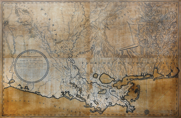
Carte Generale du Territoire D'Orléans Comprenant auffi la Floride Occidentale et une Portion du Territoire du Mississippi...
Copper plate engraved map in four sections
Paris: Charles Piquet, 1806; William Harrison, engraver
Watermark of Thomas Amies, Mill Creek Lower Marion, PA
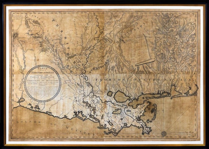
Sheet size: 33 3/4 x 49 inches; Frame size: 40 3/8 1/2 x 56 5/8 inches
La Fon's magnificent survey map was the first to accurately depict the Orleans Territory following the Louisiana Purchase.
Louisiana was divided into two parts once it was formally acquired by the United States. The District of Louisiana consisted of the lands acquired from France in the Lousiana Purchase that lay above the 33rd parallel. Its eastern border was the Mississippi River, but its northern and western boundaries remained undetermined. Its first governor, Merriwether Lewis, served in St. Louis.
The southern portion of the purchase was denominated the Orleans Territory. It was to be governed from new Orleans. At Thomas Jefferson’s request, his friend and former governor of the Mississippi Territory William Charles Cole Claiborne agreed to serve as its first governor.
Among Claiborne’s first acts was to respond to a request from the president for the best map available of the new territory. His inquiries in New Orleans caused him to respond with regret that “there are I believe (no maps of Louisiana) extant that can be depended upon …”. His search for a solution led him to one of the most interesting characters in a city known for remarkable men: the French born engineer and surveyor Barthelemy Lafon.
Lafon’s early life is unknown. He was born in France and arrived in New Orleans in about 1789. His intelligence and ambition were a perfect fit for the challenges of working in New Orleans. The city was growing at a tremendous rate, but fires, floods, substandard construction, high material costs, the native heat and humidity, rampant disease and confusing or unenforced codes added an element of chaos to that growth. Crime, organized violence by filibusters and ordinary criminals, and lax law enforcement were also constraints on regular development. And finally, political uncertainty played a role. Despite these obstacles, Lafon became one of the most successful architects and city planners in Louisiana. He is credited for numerous houses in New Orleans, as well as public works projects throughout the Parish. He served as the Deputy Surveyor for Orleans Paris from 1805 to 1809, a position that had significant power over development.
In need of a map, Governor Clairbourne enlisted Lafon to survey as much of the Orleans Territory as was feasible. The result was a detailed map covering
south from Lake Bistineau and the Red River in the North to Western Florida and Bon Secour Bay in the Southeast. Lafon's map ranks as the first comprehensive survey of Louisiana and its adjacent regions. Lafon based his large-scale map on surveys conducted between 1797 and 1805, many of which had been made to plot the location of the 31st parallel. A legend summarizes the observations of astronomers Jose Joaquin de Ferrer, William Dunbar, and George Hunter who list the coordinates for 21 towns, forts, and topographical reference points. As pointed out by Ehrenberg (2003) the forested regions north of the Red River allude to their Spanish and Indian heritage.
Lafon avoided the political ramifications of mapping the western border, placing the title cartouche over the “Neutral Ground” west of the Mississippi claimed by both the United States and Spain.
No lesser authority than Alexander von Humboldt praised Lafon’s map, writing in his 'Essai Politique Sur le Royaume de la Nouvelle-Espagne' that Lafon was a cartographer whose work sheds new light on these (unknown) regions. The map gained wide notice, as indicated by the 1805 issue of the National Intelligencer and 'Washington Advertiser': The author (Lafon) has described the counties of the territory according to the new plan of division, which he has executed himself, by order of the legislature, he lays down the latitude and longitude of the principal points. And to render it useful to mariners, he has laid down the soundings along the coast to the Gulph (sic) of Mexico.”
.. The map proved so important that a copy was sent to the postmaster general, illustrating a proposed mail route from Fort Stoddart to New Orleans.
An earlier map of Louisiana by Barthélémy Lafon appears to be lost. His Carte Générale, however, remains a foundational document in the history of the development of national cartography and three copies are preserved at the Library of Congress. REFERENCES: Barker: Old Mills of Mill Creek, Lower Merion; Ehrenberg, in Lemmon/Magill/Wiese: Chartering Louisiana; Gravell/Miller: A Catalogue of American Watermarks; Ristow: American Maps and Mapmakers.