from: June 2025 3
Olgiati & Gastaldi Map of Asia
Olgiati & Gastaldi Map of Asia
Regular price
$ 225,000.00 USD
Regular price
Sale price
$ 225,000.00 USD
Unit price
per
Couldn't load pickup availability
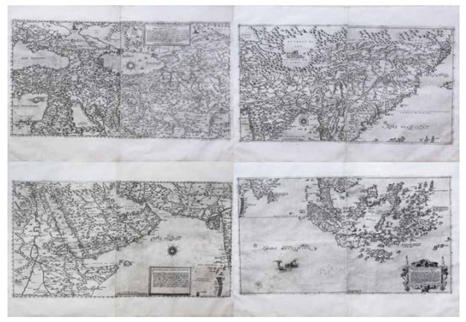
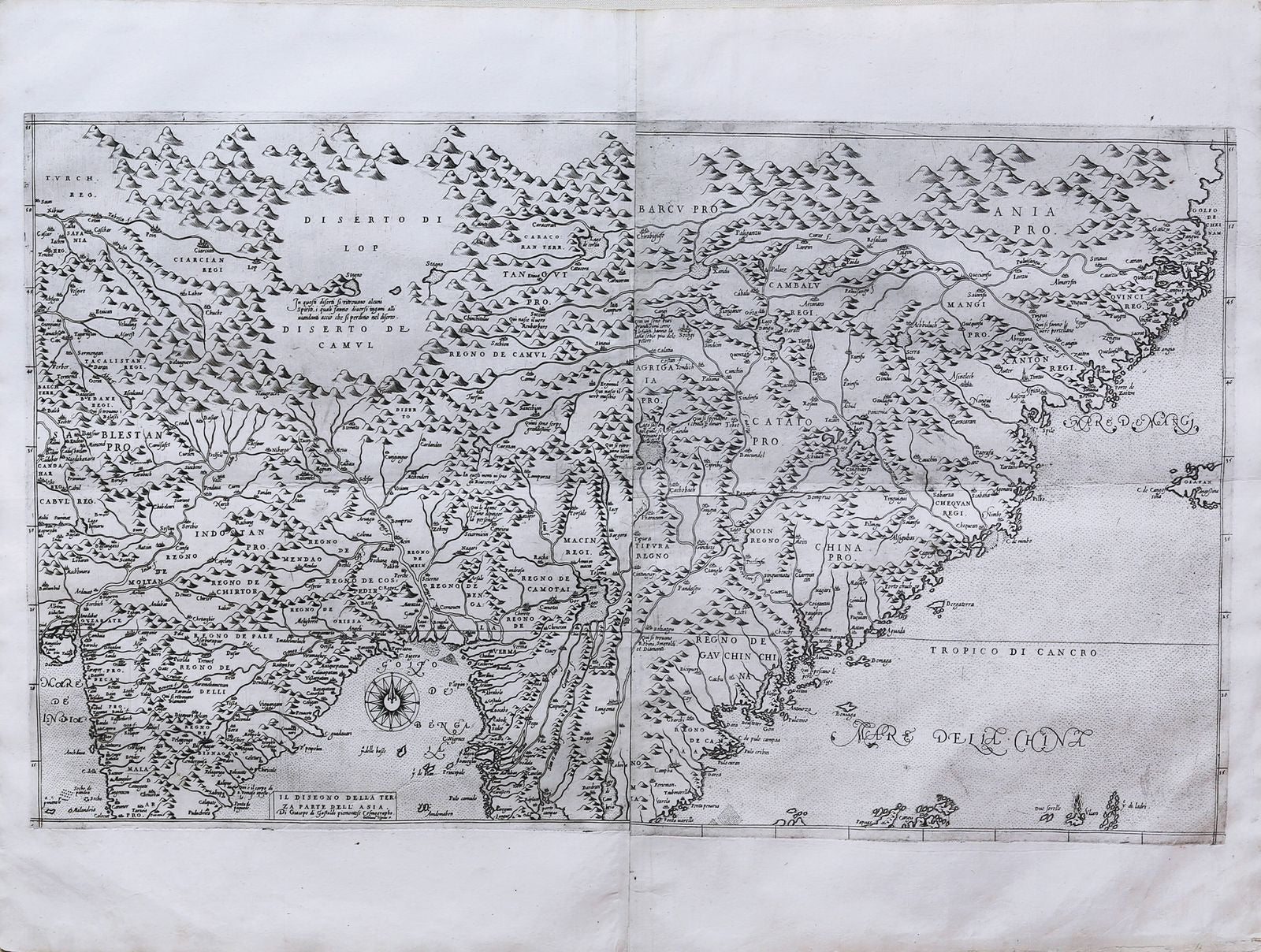
OLGIATI, Gerolamo (1453-1477) GASTALDI, Giacomo (1500-1566).
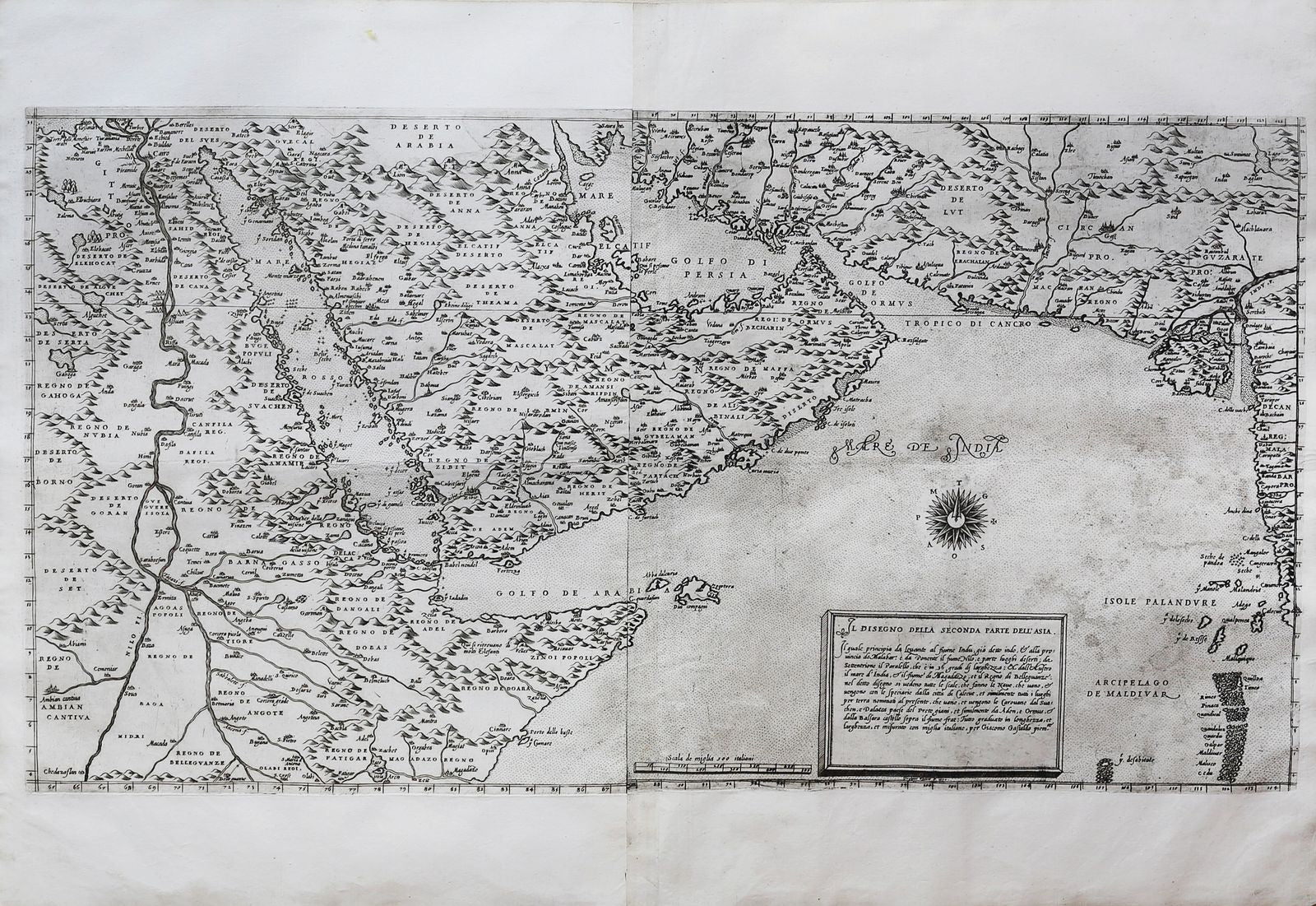
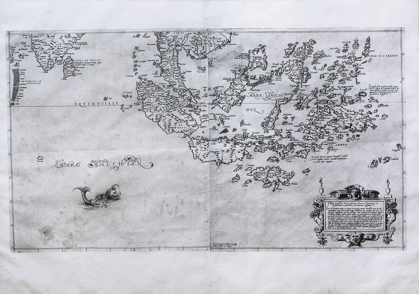
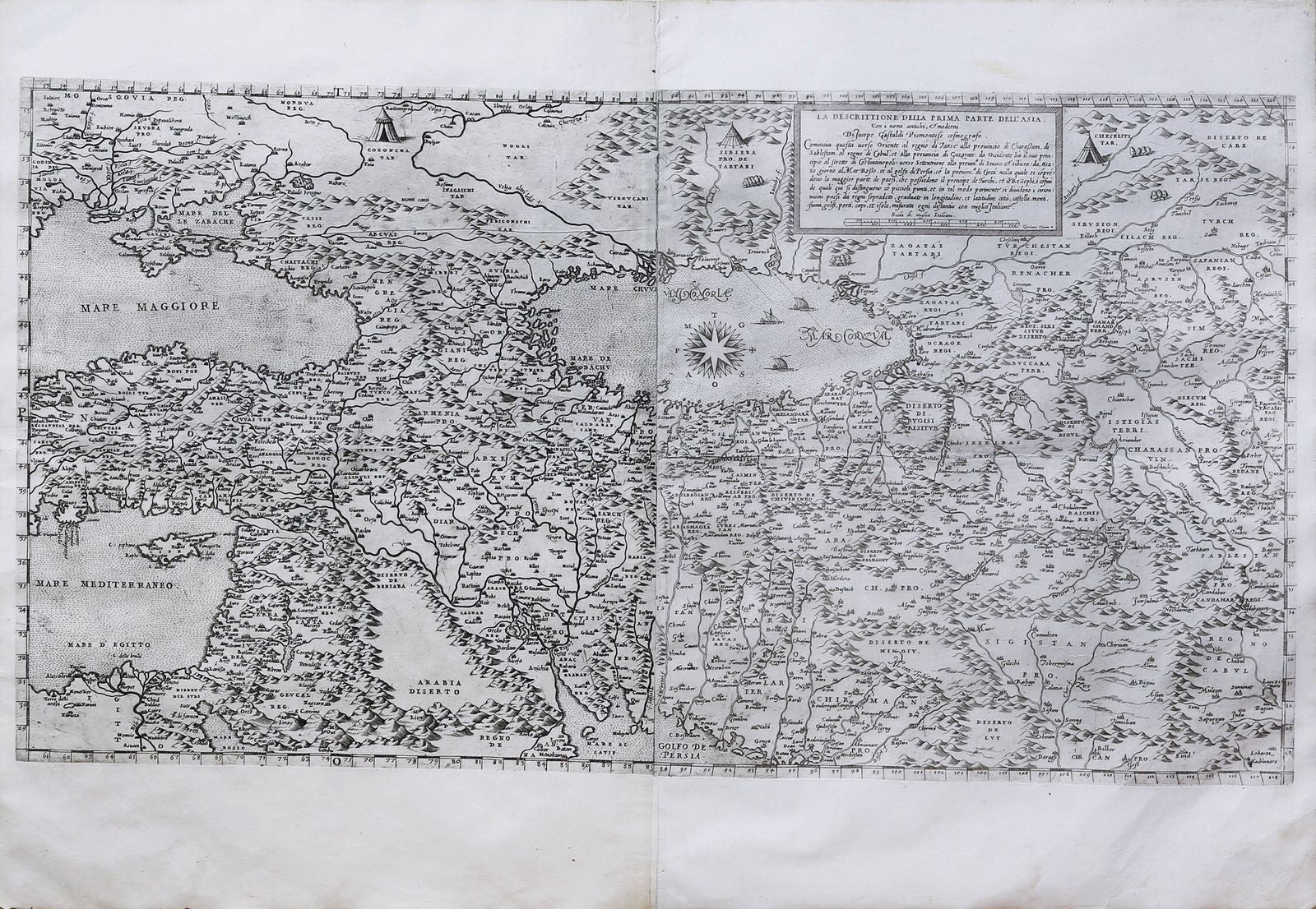
a descrittione della prima parte dell’Asia -- Il disegno della seconda [–terza] parte dell’Asia and [fourth part] -- together with two engraved gazetteers.
Engraved map in four parts, each on two sheets; framed individually.
Venice: Girolamo Olgato, 1570 (1559 - 61).
16 1/4" x 28 7/8" sheet; 32 1/2" x 42 1/4" framed, all.
Together with:
I nomi antichi, et moderni della prima parte dell’ Asia, delle provincie, regni, regioni, città, castelli, monti, laghi, fiumi, Mari, Golfi, Porti, Capi, & Isole: graduati in lunghezza, et larghezza. A ritrovare i detti nomi del dissegno, bisogna distendere un filo sopra i gradi, e minuti di lũghezza, et un’altro sopra i gradi, e minuti di larghezza: et dove i fili s’incroserano, sarà il luogho, che si ricercherà. Di Giacobo de’ Gastaldi Piamontese, Cosmografo. Engraved gazetteer on one sheet.
[And]
I nomi antichi, et moderni della seconda, et terza parte dell’Asia, delle Provincie, Regni, Regioni, Città, Castelli, Monti, Laghi, Fiumi, Mari, Golfi, Porti, Capi, et Isole; Graduati in longhezza, et larghezza. A ritrovare i detti nomi nel disegno, bisogna distendere un filo sopra i gradi e minuti de longhezza, et un’altro sopra i gradi, e minuti di larghezza, e dove i fili se incroseranno sarà il luoco, che ricercate. Di Giacomo de’ Gastaldi, Piamontese Cosmographo, in Venetia. Engraved gazetteer on one sheet.
Prima parte: sheet: 21 ¼” x 29 15/1”, 539mm x 761mm; neat line: 387mm x 718mm.
Gazetteer: 21 3/8” x 16 5/8”, 542mm x 422mm.
Seconda parte: sheet: 21 1/8” x 30 3/16”, 536mm x 766mm; neat line: 387mm x 722mm.
Gazetteer: 21 3/8” x 16 3/8”, 543mm x 416mm.
Terza parte: sheet: 31 ¼” x 30 5/8”, 537mm x 776mm; neat line: 387mm x 716mm.
[Fourth part:] sheet: 21 1/8” x 30”, 536mm x 761mm; neat line: 387mm x 702mm.
Each part framed (each ca. 32 ½” x 41 5/8”) floating and glazed. Gazetteers mounted in mylar to the reverse of the first and second parts. A little soiling to the margins of each section. Signs of damp-stain to the left-hand portion of the fourth part and to the right-hand portion of the second part, only affecting the water. Some slight marginal losses to the gazetteers
--------
Giacomo Gastaldi (or Giacopo; ca. 1500–1566) worked as an engineer in Venice before turning his attentions to mapmaking from the 1540’s; his 1548 pocket-size edition of Ptolemy’s Geografia has been called by Philip Burden “the most comprehensive atlas” produced between the 1513 Strasbourg Ptolemy and Ortelius’ Theatrum in 1570. In 1550, Gastaldi obtained from the Venetian Senate a privilege (a copyright, more or less) to print a map of Asia; the earliest known example of the first part of this work — conceived in three parts — was published in 1559 (Il disegno della prima parte dell’Asia). It was reproduced in 1561 by Antonio Lafreri (engraved by Jacob Bos). The second part of Gastaldi’s map appeared in 1561 and the third in 1562; a fourth part (a slim addition, representing less than 20° of latitude, whereas the third part shows over 50°) was issued ca. 1568 by Paolo Forlani and Ferrando Bertelli.
Following the piece-meal production of the Gastaldi-Lafreri-Forlani-Bertelli maps over nine years, Girolamo Olgiato (Olgiati, active 1567–1570), known only by his engravings, issued the present four-part map — with the seas in stipple rather than waves, as in the 1559 first part —in 1570 (though the date appears only in the cartouche of the second part). The map was issued in eight separate sheets (see the example at the Alessandrina in Rome [Rari 272], reproduced in Bifolco-Ronca), in the present example each quadrant is joined horizontally, thus with some loss to the inner scales. Bifolco-Ronca notes “i quatro fogli non sono pensati per essere uniti,” that is, they could not be joined into a single map. Indeed, even the joins of each quadrant are generally imperfect, although close enough to be considered intentional.
The gazetteers — often missing — show both the debt to Gastaldi (his name is not removed) and the holistic conception of the work: two quite similarly-formatted works, one for the first part and one for the second and third jointly. Each specifies the means of locating each place by crossing two strings at the given latitude and longitude. These were issued in two forms, letter-press and engraved, Karrow noting that the latter (as in our example) is rarer; indeed, Karrow does not know the engraved gazetteer of the second and third parts as we have.
Gastaldi’s maps — each free-standing— were far and away the most complete account of Asia; it was not until Olgiato’s 1570 edition that the whole project was unified into a single work (although the first and second parts could not in fact be joined; the third and fourth parts also overlap). Bifolco-Ronca in their 2018 Cartografia e topografia italiana del XVI secolo (vol. I, tav. 75) count in a census 5 examples complete with the gazetteers: in the privately-held “Atlante Aragona,” at the National Library in Budapest, at the Newberry Library in Chicago, at the Bayerische Staatsbibliothek in Munich and at the Biblioteca Universitaria Alessandrina in Rome. They also mention the present example, which was sold at Sotheby’s London 14 December 2000 — but, crucially, offered as three separate lots: 245 (…seconda parte), 298 (…prima parte) and 330 (…terza parte and fourth part). The consignor(s) is (are) undesignated, and so it cannot be said definitively whether the four parts are married, but given the extreme rarity of the map, they have likely traveled together since their production.
Bifolco-Ronca, vol. I tav. 75 (maps) and tav. 76 (gazetteers); Karrow, Mapmakers of the Sixteenth Century 30/85.2 (prima parte)– 30/D.2 (first part gazetteer) 30/91.1 (seconda parte)–30/92.1 (terza parte and fourth part); Tooley 1983 63a.


