|
Dear Friends,
This collection is a vibrant fusion of the local and the global. At its heart are Braun & Hogenberg’s iconic city views—panoramic snapshots of Salzburg, Seville, Mexico City, Norwich, and others, offering a Renaissance-era window into the pride and planning of early modern urban life. Whether capturing the strategic grandeur of Malta or the colonial order of Goa and Casablanca, these engravings from the Civitates Orbis Terrarum remain unmatched in charm and historical importance.
Balancing these intimate portraits are bold, world-shaping visions: Gastaldi’s monumental map of Asia, Kircher’s swirling theories of oceanic currents, and Bordone’s early oval projection of the world. Together, this group of thirteen maps charts a journey from city square to global sea.
We invite you to explore this curated selection online or in our New York gallery, where history, geography, and imagination converge.
Warmly,
Graham Arader
Arader Galleries
|
|
![Braun & Hogenberg, [Luxembourg] Lutzenburgum](//aradernyc.com/cdn/shop/files/103_580x.jpg?v=1750709773)
|
Braun & Hogenberg, [Luxembourg] Lutzenburgum
|
$ 3,500.00
|
Striking Renaissance view of Luxembourg, emphasizing its fortified importance and ducal heritage amid shifting European power dynamics during the late sixteenth century.
|
|
|
![Braun & Hogenberg, [Casablanca, Goa, Diu and Azamor]](//aradernyc.com/cdn/shop/files/106_580x.jpg?v=1750710155)
|
Braun & Hogenberg, [Casablanca, Goa, Diu and Azamor]
|
$ 1,500.00
|
Rare early views of Portuguese colonial ambitions, including a 1509-dated view of Goa used for reconnaissance during Europe’s push into Asia and North Africa.
|
|
|
![Braun & Hogenberg, [Seville, Cadiz & Malaga, Spain] Sevilla, Hispalis ... [With] Cadiz [And] Malaga](//aradernyc.com/cdn/shop/files/105_580x.jpg?v=1750710085)
|
Braun & Hogenberg, [Seville, Cadiz & Malaga, Spain] Sevilla, Hispalis ... [With] Cadiz [And] Malaga
|
$ 1,800.00
|
Vivid depictions of Spain’s major port cities, central to transatlantic trade, maritime power, and the wealth of the Spanish Empire in the New World.
|
|
|
![Braun & Hogenberg, [Mexico City, Mexico & Cusco, Peru]](//aradernyc.com/cdn/shop/files/104_580x.jpg?v=1750709920)
|
Braun & Hogenberg, [Mexico City, Mexico & Cusco, Peru]
|
$ 3,800.00
|
Earliest printed views of American cities, capturing Mexico City and Cusco as vibrant Spanish colonial capitals rooted in rich Indigenous and imperial histories.
|
|
|
![Braun & Hogenberg, [Cagliari, Malta, Rhodos and Famagusta] Calaris / Malta / Rhodus / Famaugusta](//aradernyc.com/cdn/shop/files/107_580x.jpg?v=1750710214)
|
Braun & Hogenberg, [Cagliari, Malta, Rhodos and Famagusta] Calaris / Malta / Rhodus / Famaugusta
|
$ 1,800.00
|
Strategic Mediterranean strongholds depicted at the height of Christian-Ottoman conflict, revealing key military and religious frontiers of sixteenth-century geopolitics.
|
|
|
![Braun & Hogenberg, [Saltzburak]. 1588](//aradernyc.com/cdn/shop/files/austria_580x.jpg?v=1752875218)
|
Braun & Hogenberg, [Saltzburak]. 1588
|
$ 6,000.00
|
A Renaissance-era view of Salzburg from Civitas Orbis Terrarum, celebrating ecclesiastical grandeur and alpine geography in vivid hand color.
|
|
|
![Braun & Hogenberg, [Norwich, England] Nordovicum Angliae Civitas](//aradernyc.com/cdn/shop/files/111_580x.jpg?v=1752266582)
|
Braun & Hogenberg, [Norwich, England] Nordovicum Angliae Civitas
|
$ 2,800.00
|
A vivid Elizabethan-era view of Norwich, showcasing its cathedral, wool trade heritage, and prominence in early modern England.
|
|
|
![Braun & Hogenberg, [Augsburg, Germany] Augusta Iuxta Figuram.](//aradernyc.com/cdn/shop/files/110_580x.jpg?v=1750711003)
|
Braun & Hogenberg, [Augsburg, Germany] Augusta Iuxta Figuram.
|
$ 4,500.00
|
Renaissance view of Augsburg, showcasing its Roman origins, imperial defenses, and prosperity as a major commercial and ecclesiastical center in early modern Germany.
|
|
|
![Braun & Hogenberg, [Chester, England] Cestria Vulgo Chester, Angliae Civitas](//aradernyc.com/cdn/shop/files/112_580x.jpg?v=1750797391)
|
Braun & Hogenberg, [Chester, England] Cestria Vulgo Chester, Angliae Civitas
|
$ 4,500.00
|
Early view of Chester, a Roman-founded stronghold turned Norman port city, highlighting its military, ecclesiastical, and commercial importance in medieval England.
|
|
|
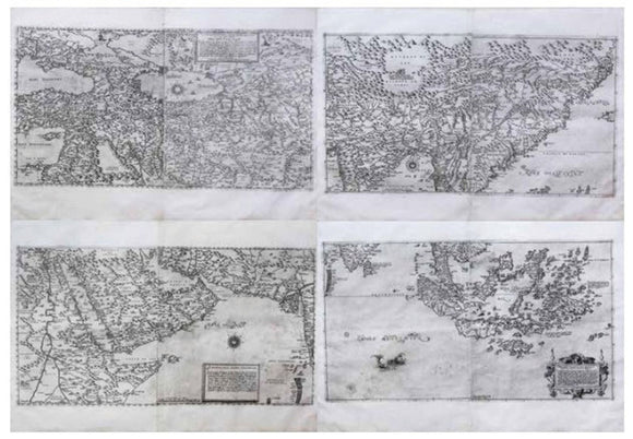
|
Olgiati & Gastaldi Map of Asia
|
$ 225,000.00
|
Impressive four-part map of Asia with detailed name index, reflecting Europe’s expanding reach during the height of 16th C European exploration and trade with the East.
|
|
|
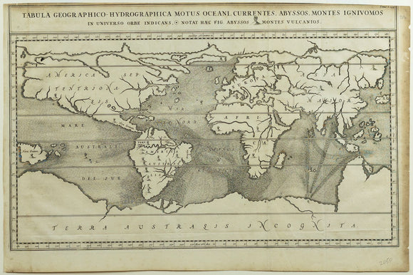
|
Kircher Tabula Geographico-Hydrographica Motus Oceani - Earliest Map of the World showing the ocean's currents
|
$ 1,500.00
|
Groundbreaking 1665 map visualizing global ocean currents, volcanic systems, and subterranean forces—Kircher’s visionary synthesis of earth science and baroque-era cosmology.
|
|
|
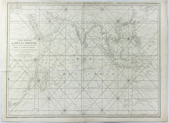
|
JEAN-BAPTISTE-NICOLAS-DENIS D'APRÈS DE MANNEVILLETTE. Carte Réduite de l'Océan Oriental... published 1771
|
$ 1,600.00
|
French Enlightenment-era sea chart of the Indian Ocean, reflecting colonial ambition, scientific navigation, and global trade routes.
|
|
|
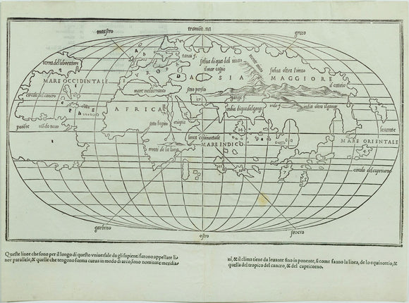
|
Benedetto Bordone, Untitled World Map
|
$ 2,500.00
|
Rare early oval-projection world map, reflecting evolving global understanding post-Columbus and influenced by Rosselli’s pioneering geographic vision of a divided New World.
|
|
|
|
|

![Braun & Hogenberg, [Luxembourg] Lutzenburgum](http://aradernyc.com/cdn/shop/files/103_580x.jpg?v=1750709773)
![Braun & Hogenberg, [Casablanca, Goa, Diu and Azamor]](http://aradernyc.com/cdn/shop/files/106_580x.jpg?v=1750710155)
![Braun & Hogenberg, [Seville, Cadiz & Malaga, Spain] Sevilla, Hispalis ... [With] Cadiz [And] Malaga](http://aradernyc.com/cdn/shop/files/105_580x.jpg?v=1750710085)
![Braun & Hogenberg, [Mexico City, Mexico & Cusco, Peru]](http://aradernyc.com/cdn/shop/files/104_580x.jpg?v=1750709920)
![Braun & Hogenberg, [Cagliari, Malta, Rhodos and Famagusta] Calaris / Malta / Rhodus / Famaugusta](http://aradernyc.com/cdn/shop/files/107_580x.jpg?v=1750710214)
![Braun & Hogenberg, [Saltzburak]. 1588](http://aradernyc.com/cdn/shop/files/austria_580x.jpg?v=1752875218)
![Braun & Hogenberg, [Norwich, England] Nordovicum Angliae Civitas](http://aradernyc.com/cdn/shop/files/111_580x.jpg?v=1752266582)
![Braun & Hogenberg, [Augsburg, Germany] Augusta Iuxta Figuram.](http://aradernyc.com/cdn/shop/files/110_580x.jpg?v=1750711003)
![Braun & Hogenberg, [Chester, England] Cestria Vulgo Chester, Angliae Civitas](http://aradernyc.com/cdn/shop/files/112_580x.jpg?v=1750797391)


