from: Maps
John Mitchell. A Map of the British and French Dominions in North America... 1755
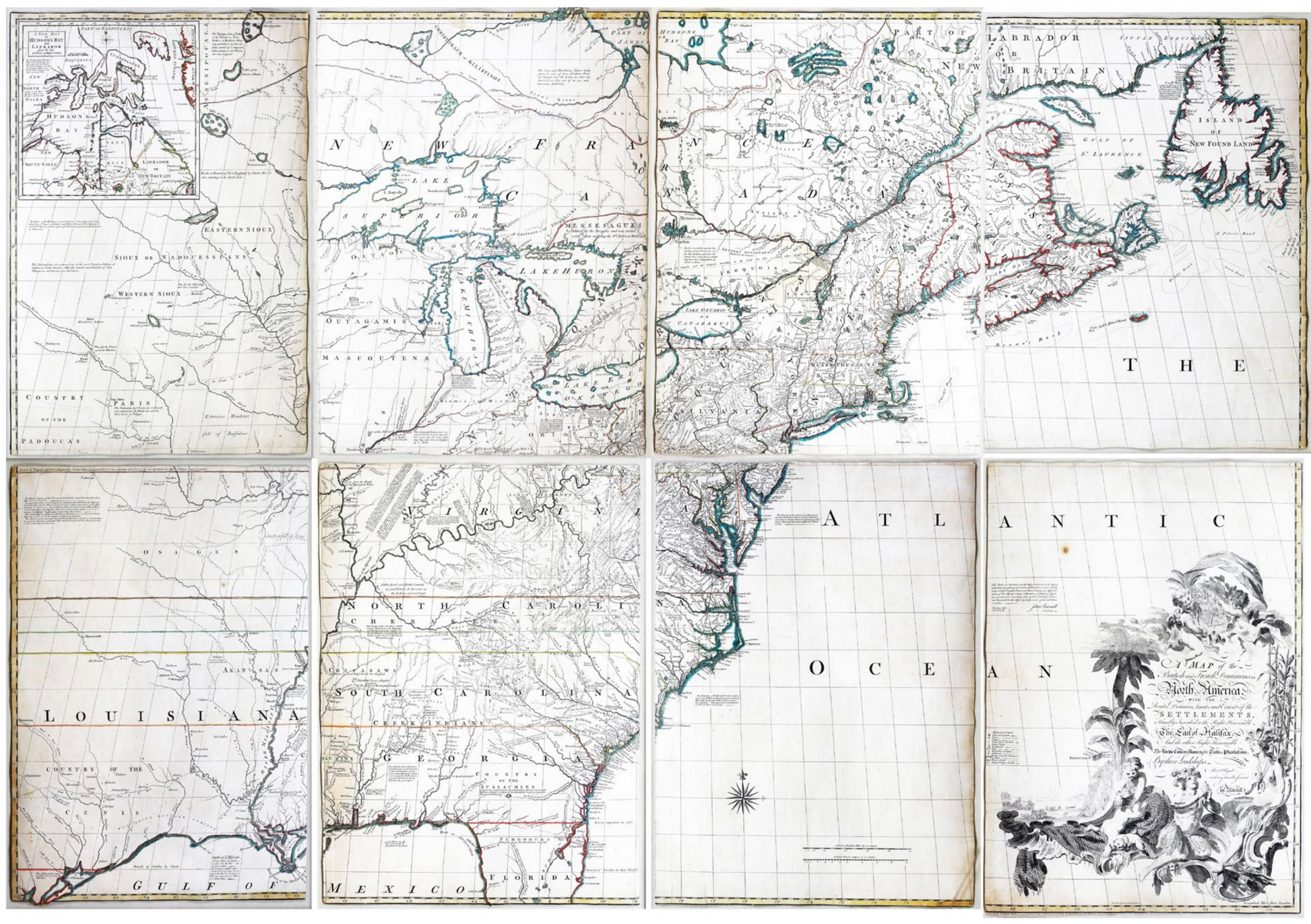
John Mitchell. A Map of the British and French Dominions in North America... 1755
Couldn't load pickup availability
JOHN MITCHELL (1711–1768)
A Map of the British and French Dominions in North America...
Engraved map in 8 sheets with original color in outline
London: 1755 (First edition, first impression)
Sheet size: 26½ x 18½ each; Frame size: 31” x 23” each
THE VANISHINGLY RARE FIRST EDITION
A MONUMENTAL engraved map of North America, by Thomas Kitchen after Mitchell, the title within a magnificent asymmetrical allegorical cartouche lower right, with original hand colour in outline. VERY RARE FIRST EDITION, FIRST ISSUE, with the imprint reading “Publish’d by the Author Febry. 13th. 1755, and Sold by And: Millar opposite Katherine Street in the Strand”. The primary political treaty map in American history and regarded by many authorities as the most important map in the history of American cartography.
How often does a tool so fully meet its intended goal that it continues to be used for two centuries? The map of the eastern part of North America made by John Mitchell (1711–1768) is such a tool. In 1750 the president of the Board of trade, the second Earl of Halifax (to whom the map is dedicated), asked John Mitchell to prepare a map of British colonies in North America. Mitchell was a close friend of the second Earl of Halifax who was also keen to furnish Mitchell with the most accurate and up-to-date surveys that had been made of the terrain. He consulted every map he could; he wrote to Cadwallader Colden that “there are none I believe but what I have consulted.” This tremendous effort made all the difference, placing this map head-and-shoulders above others, even as cartographic knowledge advanced over the centuries. The map was first drawn in 1750 but corrected, improved and unpublished in 1755. It had three aims: to be an accurate representation, to highlight the disposition and allegiance of the Native Americans who could be vital allies or enemies in the struggle with France and to promote British interests.
The enduring success of the map is all the more notable in view of its combativeness. Mitchell’s map was not neutral or nonpartisan; it was full-throatedly pro-English and anti-French. Borders were freely reimagined and transposed to maximize British territory. It would go on to set 21 states (impressions and editions) by 1781, and was translated into Dutch, French and Italian. It was the intended map that lay before John Jay during the negotiations that led to the Treaty of Paris (1783; now in the New-York Historical Society). Over two centuries, it has been used to settle issues in the British House of Commons, the Dutch Royal Court, the Supreme Court of Canada, and the Supreme Court of the United States. It is also known to have hung in the halls of Congress. The latest known use of the map is in the resolution of the 1980’s disagreement between the U.S. and Canada over fisheries in Maine.
The first impression (per Stephenson) is distinguished by the following points: “Miller” and “Katherine” for “Millar” and “Katharine” in the imprint, and “Leicester” twice above and below the third S of “Massachusets” (the lower would be corrected to Worcester in the third impression). Of this first impression, only two further examples are known: in the Library of Congress (G3300 1755 .M5) and the British Library (K.Top.118.49.c.2; George III’s copy, donated to the nation by George IV).
John Mitchell (1711–1768) respected British physician, botanist, chemist, biologist, and surveyor, lived for a time in Virginia, but returned to England in 1746, where he remained until his death. Mitchell initially conceived of his map of North America in order to present the British public with a single large format image of all the colonies, in order to illustrate the extent of the French threat to the British claims in North America. Mitchell completed his first draft of the map in 1750. However, because Mitchell was limited to publicly available sources of information, this initial effort was rather crude, even in Mitchell’s own opinion. As word of Mitchell’s work spread, the Board of Trade and Plantations retained Mitchell to make a new map, using the official manuscript and printed maps and reports in the Board’s possession, including maps by Fry and Jefferson, Christopher Gist, George Washington, John Barnwell, and others. The Board also instructed all colonial governors to send detailed maps and boundary information for Mitchell’s use.
Literature: Stephenson, Richard W. “Table for identifying variant editions and impressions of John Mitchell’s Map…” In A La Carte, ed. Walter W. Ristow, 109–113. Washington: Library of Congress, 1972. Howes M 678, Pritchard-Taliaferro 33, Stevens-Tree 54 (1755(a) “first issue”).
