from: June 2025 2
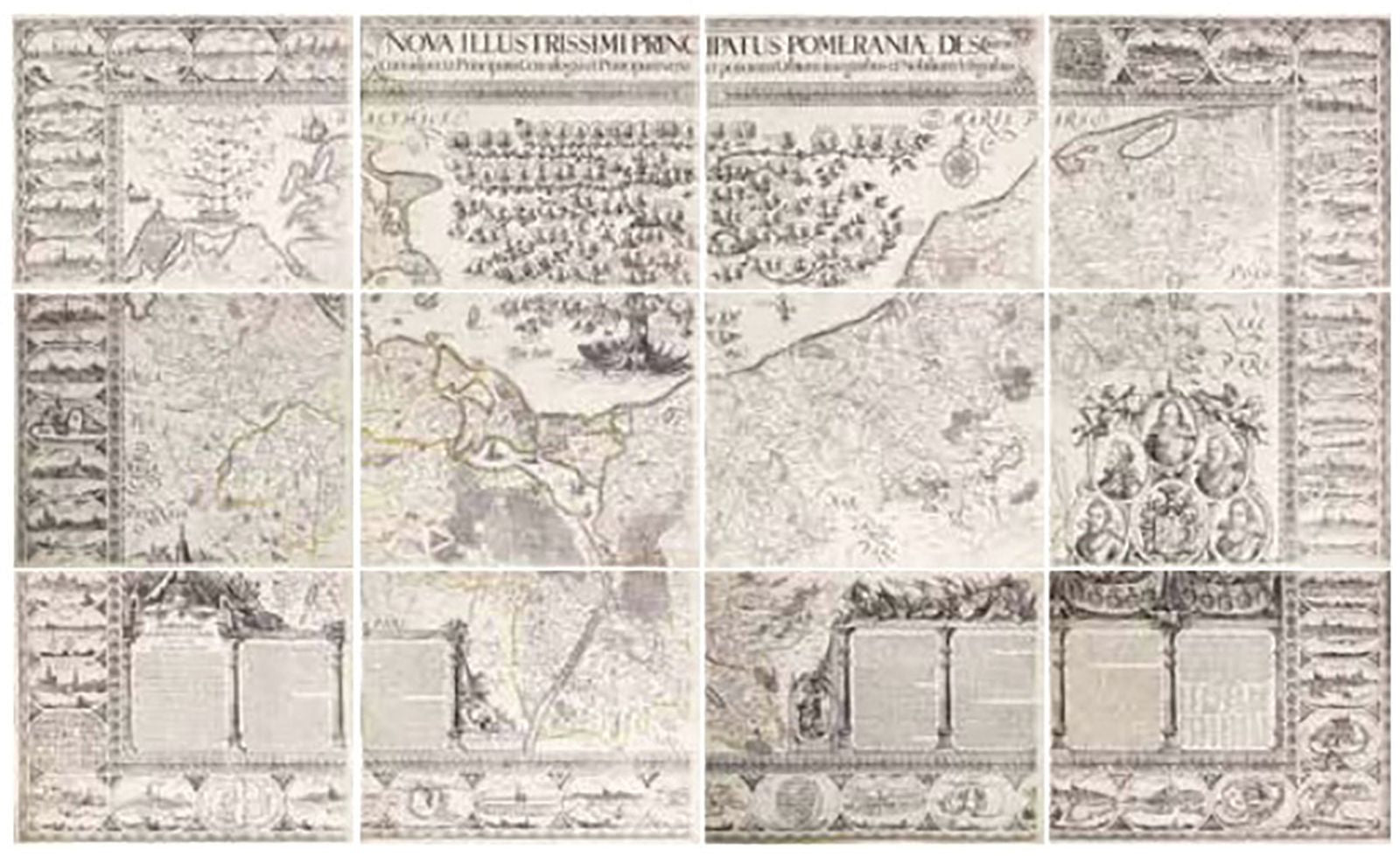
Eilhard Lubben's Map of Pomeraniae
Eilhard Lubben's Map of Pomeraniae
Couldn't load pickup availability
LUBBEN, Eilhard (1565-1621).
[POMERANIA] Nova illustrissimi principatus Pomeraniae descrptio.
Engraved wall map with original hand color in outline, in 12 sheets.
Amsterdam: Nicolaes van Geelkercken, 1618-1757.
16 1/2" x 21 1/4" sheet, each.
"Only a small number of copies were printed and so this edition is a very rare object today" (Scharfe).
THE MOST IMPORTANT EARLY MAP OF POMERANIA, the region on the south coast of the Baltic shared between Germany and Poland, from the Recknitz River near Stralsund in the west, via the Oder River delta near Szczecin, to the mouth of the Vistula River near Gdask in the east. Created by Professor Lubben of Rostock University on the orders of Philipp II, Duke of Pomerania, who wanted a large-scale map that would be a comprehensive geography and history of the duchy. It is a landmark of cartography in the great Dutch tradition and is "known in only a handful of copies. This may be the finest example to have survived" (Sotheby's).
Although Lubben had mapped the island of Rugen on the Pomeranian coast in 1609, he had very little geographic information to guide him: the only map to precede this one of Pomerania was a small map by Peter Artopaus (later used by Munster and Ortelius). Lubben spent two years Lubben travelling throughout the country taking thousands of measurements, it was then another 6 years before the copperplates were completed, by Geelkerken in Amsterdam, with the noble arms and portraits of prominent families, including one of Philippe II himself, and 46 views of towns (many depicted for the first time). However, although a very small number of the sheets printed in 1618 are known to have been presented to the Pomeranian court the shortage of paper, and the 30 years war intervened, and no known copies of this printing have survived. It was not until 1757, after Geelkerken's original copperplates were discovered in the in Stralsund (a town featured in a vignette on the map), that the map was reissued. Lubben's map was the model for virtually all atlas maps of Pomerania of the seventeenth century, including those of Blaeu and Janssonius, and Hondius dedicated his famous wall map of Asia to Lubben: see Shilder, "Monumenta Cartographica Neerlandica" VI, pp.150-151. It remained the only map of consequence of the region from its inception in 1618 until the Prussian topographical survey of the eighteenth century.
