from: Americas
Ortelius, Abraham. The Gulf of Mexico from Florida to Texas to Tampico. Antwerp: 1592.
Ortelius, Abraham. The Gulf of Mexico from Florida to Texas to Tampico. Antwerp: 1592.
Couldn't load pickup availability
Abraham Ortelius
The Gulf of Mexico from Florida to Texas to Tampico
Antwerp: 1592
18 ½ x 22 ¾ inches
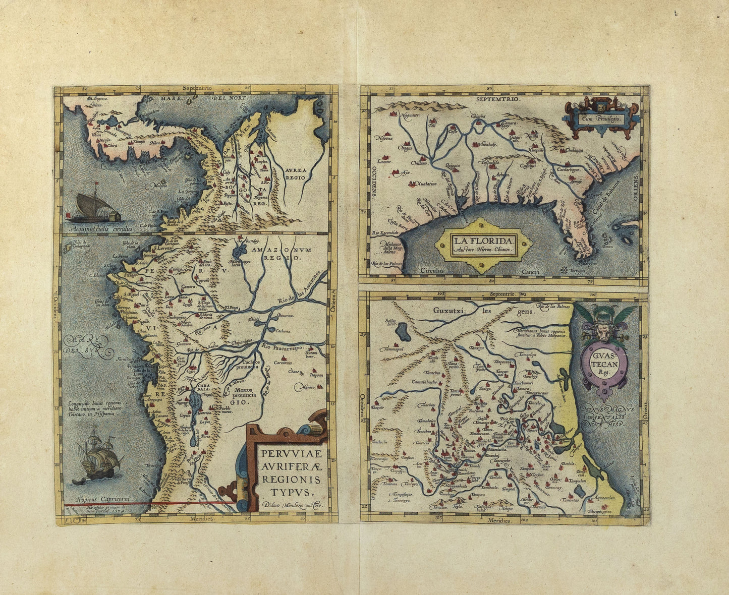
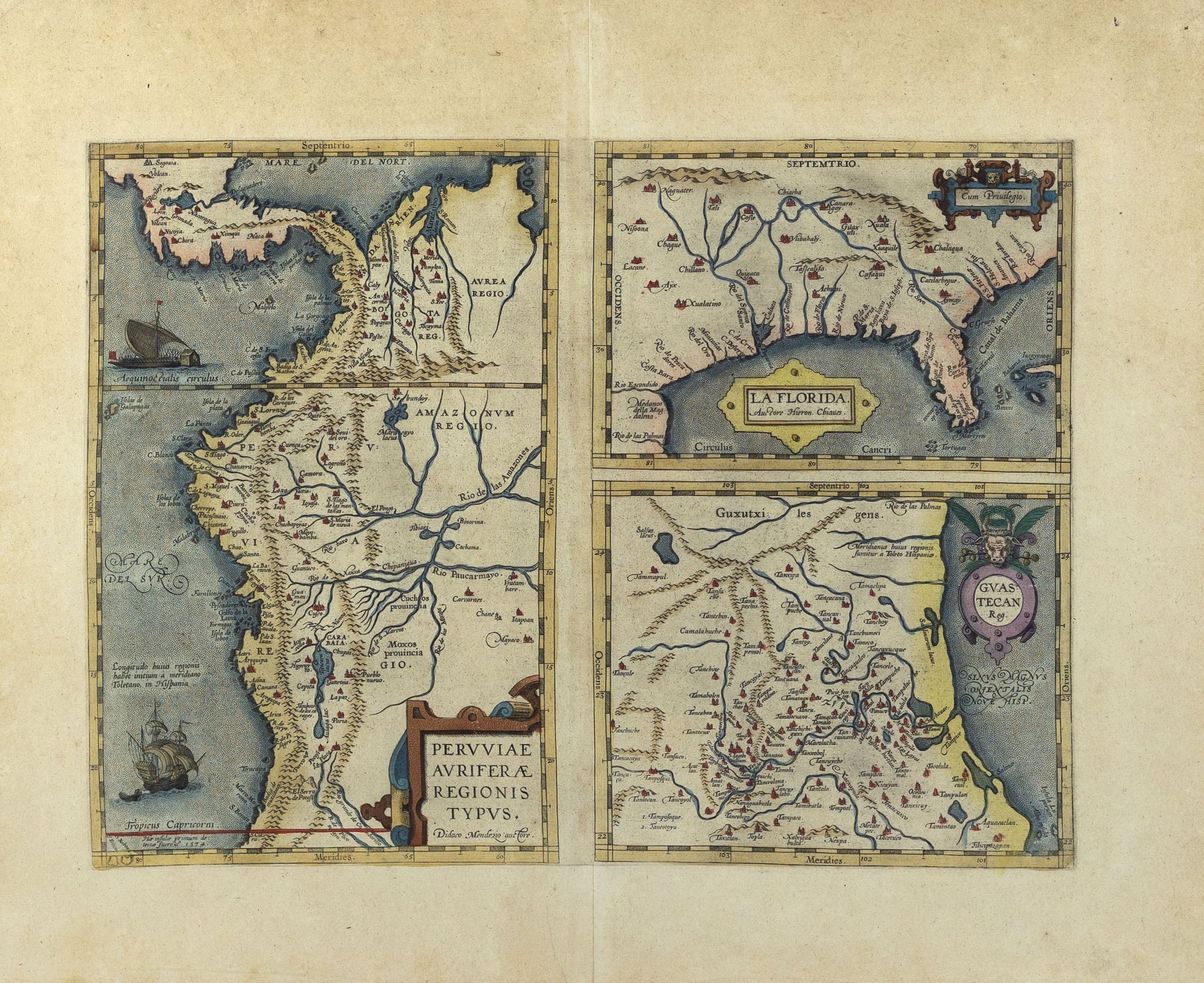
Three maps on one sheet:
MÉNDEZ, Diego de. Pervviae avriferæ regionis typvs. Didaco Mendezio auctore. [text in block at lower left] Hæ insulæ primum detecta fuere ao. 1574.
CHAVES, Gerónimo de. La Florida. Auctore Hieron Chiaues. [cartouche at top right] Cum Priuilegio.
Gvastecan Reg
Ortelius included this map in his atlas beginning in 1584. The present map appeared in a Latin edition of Ortelius’ Theatrum Orbis Terrarum, the first modern atlas of the world (Phillips, Atlases 392). Together, the three maps show the most significant parts of the New World in the last decades of the sixteenth century and the first half of the seventeenth century. Burden, The Mapping of North America 57, pp. 71-73. “One of the half-dozen most important mother maps of southeastern North America.” Martin & Martin, pp. 18 & 75n: “Privy to all of the official reports of the Spanish explorers, Chaves’ map recorded the discoveries of Cabeza de Vaca, de Soto, and Moscoso. One of the earliest printed maps of the territory based on actual observations.” Schwartz & Ehrenberg, The Mapping of America, Plate 35, pp. 73 & 79-80 (illustrating and discussing La Florida): “First regional map of Florida, shown in coastline from Carolina to Mexico.” TCU, Going to Texas: Five Centuries of Texas Maps, Plate 2, p. 9. Van den Broecke, Ortelius Atlas Maps, State 15a.1 (Peru); 15b.1 (La Florida); 15c.1 (Guastecan). Van der Krogt, Koeman’s Atlantes Neerlandici, Vol. IIIA, 31:041 (9)9.
Cumming, The Southeast in Early Maps 5, Plate 9n (“La Florida”), and p. 1:
Ortelius’ map of Florida, which was based upon information derived from the Spanish royal cartographer Chaves, included the territory south of the present latitude of Virginia and west to New Mexico. This map is not as accurate as Mercator’s and in its nomenclature is based upon early Spanish explorers; but it is the first printed regional map and remained the basis for the charts of many continental mapmakers for over a century. It is a mother map of the first importance, for its general geographical outline is found in many maps, in which the details were revised and corrected upon occasion as additions to geographical knowledge were acquired, until the beginning of the eighteenth century.
Dennis Reinhartz & Charles C. Colley, “Spanish and French Mapping of the Gulf of Mexico in the Sixteenth and Seventeenth Centuries,” pp. 8-11 in The Mapping of the American Southwest, Texas A&M Press, 1987, designating Ortelius’ La Florida as the “Type Two, 1544-1680” Gulf of Mexico map, with a network of rivers and a mountainous barrier to the north, which “was to become the standard map for the next 130 years.... In the latter sixteenth century, the most widely disseminated Type-Two map was that published [by] Abraham Ortelius. This map is ascribed to Gerónimo de Chaves, Spanish royal cosmographer who worked at Seville in the Casa de Contratación. It is less detailed in its account of the internal settlements than the Alonso de Santa Cruz map of 1544 [but it] was very influential, and not merely in successive editions of the Theatrum.”
The map Pervviae avriferæ regionis typvs shows part of Central America and northwest South America. In northern Peru is Aurea Regio, or Kingdom of Gold, perhaps a reference to the fabled El Dorado. The map of Florida is generally considered to be the first printed map attempting to delineate any part of the interior of the present U.S. It influenced all maps of the region for a century and is “a primary source document of the first magnitude in the history of discovery and cartography” (Rucker Agee, Birmingham Pub. Lib. Cat. 1970). La Florida covers the area from Colorado-Kansas south to Rio de las Palmas (often said to be the Rio Grande, but in reality, the Soto la Marina River in Tamaulipas), east from Texas to the tip of Florida, and north along the Atlantic, showing the present southeastern United States. The map below shows the Guastecan region, depicting the eastern shore of Mexico, extending the coastline of the Gulf of Mexico from Rio de las Palmas to south of Tampico. Its creator is unknown, but based on the reckoning of the longitude it has been suggested to be the work of Chaves, the same cartographer who delineated the Florida map (see Howard Cline, “The Ortelius Maps of New Spain, 1579, and Related Contemporary Materials, 1560-1610,” p. 104 in Imago Mundi, Vol. 16, 1962).