from: Maps
Peter Apian (1495-1552). Tipus Orbis Universalis...1520
Peter Apian (1495-1552). Tipus Orbis Universalis...1520
Couldn't load pickup availability
Peter APIAN (1495-1552) & Pomponius MELA (fl. AD 43)
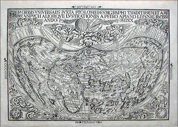
Tipus Orbis Universalis Iuxta Ptolomei Cosmographi Traditionem et Americi Vespucii Aliorque Lustrationes
a Petro Apiano Leysnico Elucbrat An. Do. MDXX
Vienna, 1520
Sheet: 12 3/4” x 17 3/4”, framed: 24” x 29 1/2”
Fine woodcut map of the world in a cordiform projection by Laurent Fries, the title within a banner along the top edge, with a globe and sphere hanging beneath, the compass directions outside the neat line, showing North and South America, all surrounded by an elaborate border of windheads, wreaths and clouds.
THE FIRST AVAILABLE PRINTED MAP TO BEAR THE NAME AMERICA
Europe’s sixteenth-century quest for geographical knowledge was primarily driven by trade. Europeans sought maritime routes to the East that could avoid the long, uncertain and expensive overland routes we call the Silk Road. As explorations revealed the existence of new lands, as well as a clearer picture of known but distant ones, mapping took on new importance. Consequently, the principal trading states of Europe – the regions that now constitute Italy and Germany -- also became leaders in the printing of maps. In Italy, Venice was pre-eminent, due to its historic maritime power and its role as the terminus of the Silk Road. In the German region Nuremberg, the Rhineland and Vienna all sat astride important land routes that enabled trade inside of Europe.
Peter Apian, also known by his Latin name Petrus Apianus (1501-1552), was a professor of mathematics in Vienna. He also held mathematic chairs at Ingolstadt and Innsbruck and was known as an able astronomer. These skills combined with his interest in geography led to the establishment of his own printing press in Landshut.
In 1520 Apian’s world map appeared in a Vienna edition of Caius Julius Solinus’ Third Century dissertation on the wonders of the natural world, published by the humanist scholar Johannes Cramers. The map’s lengthy title translates as “Delineation of the entire world prepared according to the teaching of Ptolemy the cosmographer, and the voyages of Americus Vespuccius and others by Peter Apian of Leissig.” His map uses a truncated cordiform projection, and in this and other ways is clearly derived from Waldseemuller’s 1507 world map. North and South America are not connected with Asia, but appear as narrow strips of land separated by a wide channel. The northern continent is called merely “Terra incognita,” but the southern has the inscription: “Anno d 1497 haec terra cum adiacetib, insulis inuenta est per Columbum Ianuensem ex mandato regis Castellae America puincia”, in homage to Columbus as the discoverer of America, rather than Amerigo Vespucci, whom Waldeseemuller had named the landmass for on his map of 1507. Highly detailed and copious notes appear throughout the map, including references to Vespucci’s 1491 discovery of America, which claim was actually based on what we now know to be forged letters, made so that the Florentine Vespucci could claim to have beaten the Genoan Columbus to the New World. Asia is described in detail, but the map lacks some of the most recent Portuguese discoveries that Ruysch had included in his map.
Three sets of initials appear cut into the woodblock: “Laurent Fries, whose initials appear in the lower right-hand corner, was probably the co-draughtsman or woodcutter. the other initials are those of Johann Kamers (Camertius) in whose book the map appeared and (in monogram form) L A or Luca Alantses who paid for the production of the map.” (Shirley 45).
Church 45. Sabin 86390; Shirley 45; Harrisse, The Discovery of North America 126; Harrisse, Bibliotheca Americana Vetustissima 108.