from: 1016 Map Inventory
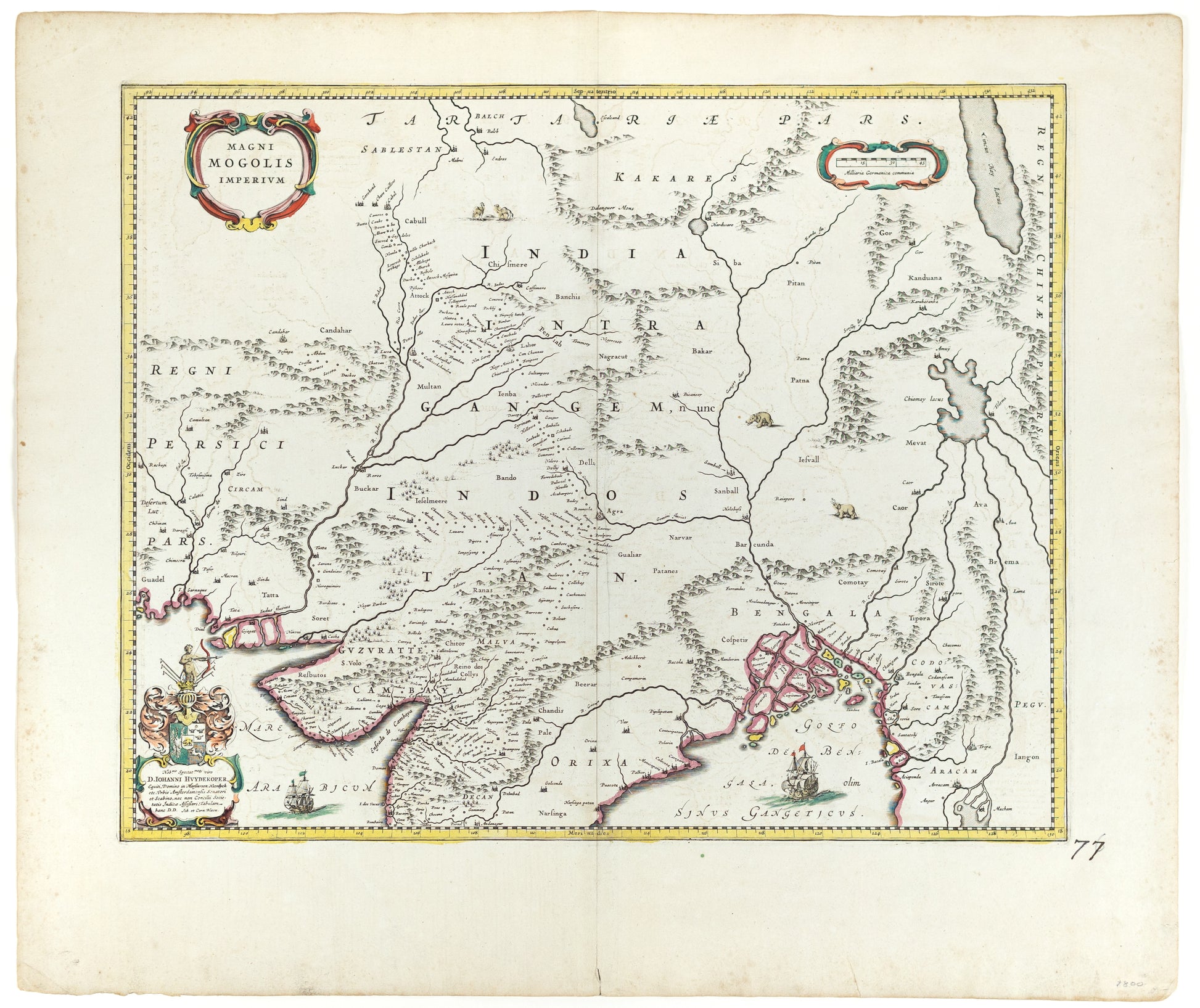
Blaeu, William. Magni Mogolis Imperium. Amsterdamn, 1640s.
Blaeu, William. Magni Mogolis Imperium. Amsterdamn, 1640s.
Couldn't load pickup availability
Willem Blaeu
Magni Mogolis Imperium
Amsterdam: c. 1640
21 1/4" x 24 7/8" sheet
A marvelous 1640 map by Joan and Cornelius Blaeu representing the kingdom of the Great Mogul in northern India. Extending from the Indus River Valley to the Irrawaddy River Valley and from Tibet to Bombay, this map covers much of modern day India as well as parts of adjacent Pakistan, Afghanistan, Nepal, and Tibet. Caravan routes are clearly apparent as chains of small cities, for example from Agra, across Rajasthan to Jaisalmer (Gislemere). Beautiful engraved sailing ships fill the seas and animals, including camels and elephants, decorate the land.
Much of thecartography here is based upon the 1618 Willliam Baffin, who in turn received reports from Sir Thomas Roe. Roe was the ambassador of King James I of England the Mogul Emperor Jahangir c. 1615.
Blaeu offers a striking depiction of the apocryphal Lake of Chiamay appears just north of the Bay of Bengal as the source of four important Southeast Asian river systems including the Irrawaddy, the Dharla, the Chao Phraya, and the Brahmaputra. The curious Lake of Chiamay (alsocalled Chiam-may or Chian-may), roughly located in the area of Assam but sometimes as far north as Tibet and China, began to appear in maps of this region as early as the 16th century and persisted well into the mid 18th century. Its origins are unknown but may originate in a lost 16thcentury geography prepared by the Portuguese scholar Jao de Barros. It was speculated to be the source of five important Southeast Asian River systems and was mentioned in the journals of Sven Hedin, who disputes the notion. There are even records that the King of Siam led an invasionary force to take control of the lake in the 16th century – although this may in fact be a reference to the conquest of Chaing Mai. Nonetheless, the theory of Lake Chiamay was ultimately discredited and largely disappeared from maps entirely by the 1760s.
This map was prepared by Joan and Cornelius Blaeu, sons of Willem Janzoon Blaeu, for publication in the 1640 French edition of the Atlas Maior.
