from: Italia
Scolari, Stefano (c. 1612-1691) after Matteo Greuter (1564-1638). [Italy] Novissima ac Exactissima Totius Italia Descriptio Magna. Venice, 1657.
Scolari, Stefano (c. 1612-1691) after Matteo Greuter (1564-1638). [Italy] Novissima ac Exactissima Totius Italia Descriptio Magna. Venice, 1657.
Couldn't load pickup availability
Stefano Scolari (c. 1612-1691) after Matteo Greuter (1564-1638
Novissima ec Exactissima Totius Italia Descriptio Magna.../ Italia di MAtteo Greuter Revista et augmentata di molti luoghi principali MDC. LVII
Engraved map
Venice: Scolari, 1630 (1657)
87 1/2” x 47 1/2” sheet
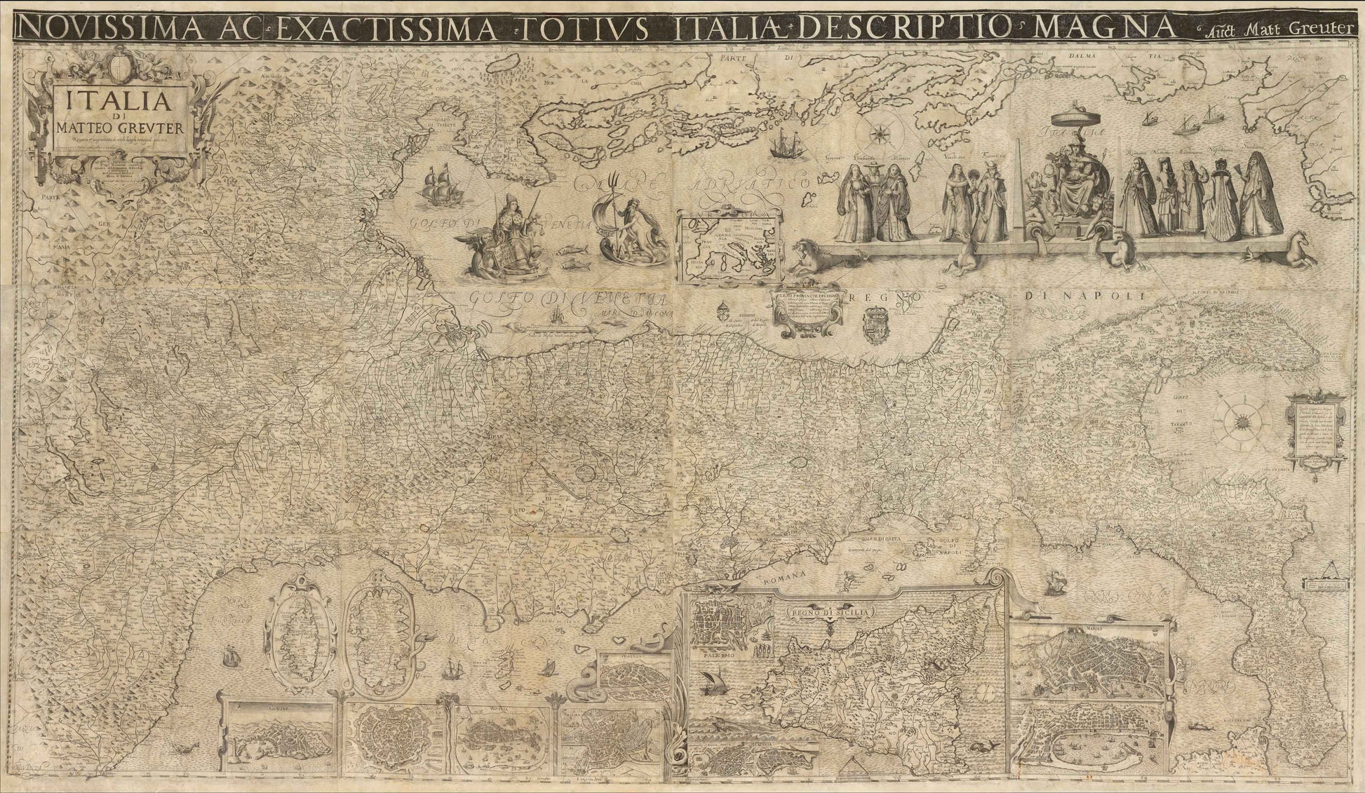
INCREDIBLY RARE RENAISSANCE MAP OF ITALY - ONLY KNOWN EXAMPLE WITH DECORATIVE TITLE BLOCK
Atypical to most maps of Italy, the map is oriented with the northeast at the top. The map notes, “Questo Geografico Disegno è Voltato à traverso per la Comodità del Lettore.” In English, “This geographical design is turned sideways for the comfort of the reader...” Greuter and Scolari spare little in cartographic detail. The interior is teeming with markings for hundreds of villages and towns. The infrastructure is not denoted by a single symbol — as was common in maps of this scale — but painstakingly details the size and type of church the locale has, the scale of the settlement, provincial and familial coats of arms, and dotted lines to separate political entities. Certain cities have recognizable features to modern eyes, including St. Peter’s Basilica and the city walls of Rome. Hills and mountains are also marked, some with unique features such the cavernous hole depicting Mount Vesuvius near Naples.
The longitudes shown are relative to the Cape Verde, and islands, cities, and landmarks are printed in Italian. The three major islands of Sicily, Sardinia, and Corsica are shown separately as insets. Views of major Italian cities are also shown, including Genoa, Milan, Venice, Rome, Florence, Palermo, Syracuse, Catania, Naples and Messina. An inset map of Europe rests in the Adriatic Sea.
In the Gulf of Venice, a hand emerges from the waves to point to a scale in Venetian miles. It is protected by a Venetian vessel and menaced by a hungry sea-bear. Just below the main allegorical vignette (discussed below) is a cartouche with the twelve southern provinces of the Kingdom of Napoli. This cartouche is flanked by coats of arms. Many ships are adrift in the waters all around Italy.
In the Mediterranean, to the south of the peninsula, a cartouche houses a brief text explaining the orientation of the map. The decorative but not ostentatious strapwork on this cartouche is echoed in the title cartouche in the upper left, as well as in the inset maps and views below. There is also a compass rose with the directional winds labeled. Slightly farther east is another scale measuring twelve miles and topped with dividers.
The title cartouche contains a dedication to Signore Gioseppe Sauoldo, a judge of the College of Brescia. Brescia, a province and city in Lombardy, was then under Venetian rule. Sauoldo was also the consigliere, or advisor, to the Elector and Duke of Bavaria. In 1657, when the map was reissued, this was Ferdinand Maria, who ruled Bavaria from 1651 to 1679. Ferdinand needed the advice of men like Sauoldo, for he was only 15 when he ascended to the position of Elector. He was officially crowned in 1654 and is known for modernizing the Bavarian army and introducing the first Bavarian local governmental code.
Greuter’s map of Italy must have been popular, as it was reissued several times over the course of nearly two centuries. First, it was re-released in Venice by Stefano Scolari in 1657; then, by Pietro Tedeschi and Giuseppe Longhi in Bologna in 1676; and then, by Domenico De Rossi in Rome in 1695. Finally, Tedeschi and Longhi released another example in 1713.
ALLEGORICAL FEATURES
The rich allegorical figures at the top right are yet another visual treat of this map. These center around a female representation of Italy, seated on the throne, with the Po and Tiber rivers at her feet. On either side are the trappings of civilization, including armor, a vase, an artist cherub, musical instruments, and crowns. To the left and right, Italy is flanked by five costumed ladies representing the various provinces of the region. On the left, the Northern cities of Genoa, Lombardy, and Milan stand separate from Venice and Florence. Milan and Lombardy were firmly under Spanish imperial control, while Genoa was a powerful but dependent ally, whose wealth helped fund Spanish wars in exchange for protection and prestige. Their subjection is evidenced by their conservative fashion. Donna Milanese even sports a ruff — a stiff pleated collar that had fallen out of vogue in Europe at large by the early 17th century but lingered for decades after in Spanish clothing. To the right, Rome, and two women from Noto and the Amatrice region (whose physical depiction is likely referencing a late 16th century series of ancient regional costumes. Donna Matriciana maintains the positioning of the series, though lacking the torch and spool she is meant to hold). The woman from Naples stands with her back to the viewer (and perhaps to Italy herself), likely representing the period of social and political turmoil in the region. Naples was similarly under Spanish rule throughout the 17th century, but the Neapolitans voraciously supported the imperial army, crushing their economy and increasing public debt fourfold. Sicily — the last depicted region of the Spanish Empire — is outfitted with a mantilla veil, standing furthest from the personification of Italy.
To the left of these women is Neptune with his trident. Interestingly, Neptune floats in a shell filled with wares and propelled by a sail as opposed to riding on a chariot drawn by horses. By the 17th century, Italy’s overwhelmingly Catholic population had conflated depictions of the Greek Poseidon with the Roman Neptune, but Greuter has made the choice to differentiate the two, divorcing Neptune from association with equine forms or the god Consus, protector of grain and most recognized by horse iconography. This decision was likely to highlight Venice’s mercantile success, but has nationalistic undertones and suggests a cultural purity, as Consus was the deity who urged Romulus to abduct and rape the women of Sabine — a contentious period of Roman hisotry that incorporated the region of present-day Umbria. The figures are thrown into further theological tension, as the Roman goddess Justitia sits to the left of Neptune, draped in ermine and sumptuous clothes. She holds the scales of justice and a sword, but additionally sports the corno ducale, a horn-like bonnet made of brocade and embellished with gold and gems, invoking the Doge of Venice. Next to her on the decorative shell in which she floats is a lion holding a book which proclaims, “Pax Tibi Marce Evangelista Meus,” translating to “Peace be with you, Mark, my evangelist.” According to legend, these words were uttered by an angel who appeared to St. Mark in a dream after landing on an island in the Venetian lagoon. The phrase was understood as a prophecy that the saint would find rest, devotion, and honor among the Venetian population. The prophecy was fulfilled eight centuries later, when Saint Mark’s body was smuggled out of Alexandria in a shipment of pork and vegetables. The most famous church of the city is the Cathedral Basilica of St. Mark, built to house his remains, and double as the chapel of the Doge of Venice.
Together, the decorative elements of Scolari and Greuter’s map dramatize a broader ideological struggle: Catholic piety is put in conversation with Roman dieties, republican virtue overlaps with imperial ambition, and regional pride sits uncomfortably against the backdrop of foreign rule. In symbolically portraying these contradictions, Scolari and Greuter’s map goes beyond charting geography, and becomes a visual argument for Italy’s fragmented identity, torn between a classical past, papal authority of their present, and the pressures of emerging nationalism.
EDITIONS & RARITY
Greuter’s original Rome edition from 1630 does not survive but two later states are known: a 1640 (Bibliotheque National de France) and a 1647 (Mediateca di Santa Teresa di Milano).
Scolari’s Venice edition of the map survives in very few recorded examples. These include examples in the Biblioteca Nazionale di Firenze (Fondo Palatino) and the Bibliothèque Nationale de France. There is also a privately-owned example in Rome.
GREUTER & SCOLARI
The Strassbourg-born Matteo Greuter (Matthaus, 1564–1638) published many religious and mythological scenes throughout his life, the antithetical nature of which is not unsurprising, as Greuter converted to Catholicism in middle-age. He first moved to Avignon with his three children, and in 1603, settled in Rome and opened a shop in the Piazzadi San Marcello. His first year in Rome afforded him success, evidenced by his 1604 petition for a 10 year papal privilege (a copyright, essentially) on a blanket statement of “engravings.” The penalty for violation was no pittance. A fine of 500 gold ducats (today, roughly $180,000) was to be divided between Apostolic Chamber, Greuter, the accusers, and the judges. His precautions were warranted, as he quickly rose to prominence and is most well-known for the technological feat of his grand twelve-sheet map of Italy, considered one of the finest ever produced of the country. Greuter produced countless maps of Italian cities and is known to have engraved several globes for a variety of patrons, including Cardinal Scipione Boghese, Pope Paul V, the Accademia dei Lincei, and Pope Urban VIII. He additionally created the plates for Galileo’s Macchie Solari [Letters on Sunspots] (1613) using a combination of engraving (maneuvering a tool to carve) and etching (utilizing acid to corrode the surface of the metal) to develop a sophisticated variation in tones that mimicked the smoky, ephemeral sunspots Galileo described.
Greuter was strongly influenced by his Dutch counterparts, especially Willem Blaeu, whose globes he diligently updated. Stevenson notes that during the last years of his life, Greuter went on to produce a 1635 celestial globe and several reduced-size globes. Following Greuter’s death in 1638, Giovanni Battista Rossi and, later, Domenico de Rossi, released subsequent Greuter globes. A number of these are detailed in Elly Dekker’s book Globes at Greenwich and Stevenson’s Terrestrial and Celestial Globes.
Stefano Scolari (c. 1612–1691) was known primarily as an illustrator and would be among the first engravers to devote his activity entirely to illustrated editions. His work included pieces drawn and engraved by himself, images produced in collaboration with other artists and editors, and the reproduction of already published copperplates, such as this re-issue. Originally from Brescia, Scolari practiced his trade in Venice. His shop, in San Zulian under the sign of the Three Virtues, was one of the best known in 17th century Venice.
![Scolari, Stefano (c. 1612-1691) after Matteo Greuter (1564-1638). [Italy] Novissima ac Exactissima Totius Italia Descriptio Magna. Venice, 1657.](http://aradernyc.com/cdn/shop/files/ScolariGreuterItaly.jpg?v=1754081611&width=1445)