from: The Finest Corpus of 18th and 19th century Watercolors Relating to South America Extant
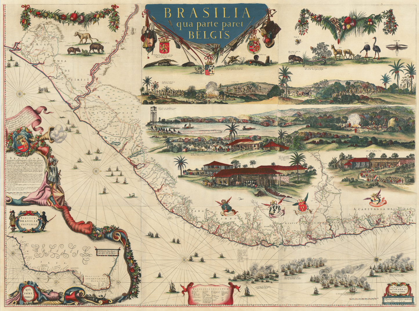
Rambout van de Hoeye. Brasilia qua parte paret Belgis. 1652.
Rambout van de Hoeye. Brasilia qua parte paret Belgis. 1652.
Couldn't load pickup availability
RAMBOUT VAN DE HOEYE (AFTER GEORG MARCGRAF)
Brasilia qua parte paret Belgis
Engraved map on laid paper with hand color, heightened in gold
Amsterdam, 1652
Sheet size: 48 x 63 ½ inches
THE SUPERLATIVE MAPPING OF BRAZIL IN A PREVIOUSLY UNKNOWN FIRST WALL MAP STATE
This monumental and newly discovered wall map represents the most ambitious and final Dutch cartographic vision of Brazil before its recapture by the Portuguese in 1654. Based on the meticulous surveys of polymath Georg Marcgraf and enriched with vignettes drawn from the work of Frans Post—the first European artist to depict landscapes of the Americas—this 1652 edition marks a pivotal moment in the scientific and artistic documentation of South America.
Depicting the northeastern coast of Brazil from Salvador to Natal, the map offers extraordinary detail: hundreds of place names, captaincy coats of arms, geographic notations, and four illustrated naval engagements between Dutch and Iberian fleets. Above, a menagerie of indigenous fauna exemplifies Marcgraf’s pioneering natural history research, while a cartographic inset in the lower-left corner situates Dutch Brazil within the broader context of Portuguese South America.
In the upper right, four compelling vignettes—after Post—provide rare and vivid insight into life in the colony. One panel depicts Tupinambá rituals, including a controversial scene of cannibalism likely based on eyewitness testimony; another illustrates a sugar mill rendered with such technical precision that it has been called blueprint-worthy. Together, these scenes offer an unmatched visual narrative of daily life in Dutch Brazil.
A “Missing Link” in Dutch Cartography
This previously unrecorded edition bridges the gap between Johannes Blaeu’s 1647 book-form map and the later wall maps issued by Hugo Allard and Clemendt de Jonghe. It is the first known wall map format based on Marcgraf’s manuscript, engraved on nine uniformly sized sheets. The imprint in the lower right corner—“Rombout van den Hoeye excudebat Anno 1652”—firmly attributes the map to van den Hoeye and clarifies the chronological and editorial relationship between the major publishing houses.
Its importance lies not only in its rarity but in what it reveals about the visual strategies used to promote Dutch Brazil. Commissioned at the height of Dutch power under Count Johan Maurits of Nassau-Siegen, the map served both as a scientific atlas and a colonial marketing tool—an effort to entice settlers, investors, and patrons through the lens of scholarship and art.
Provenance and Rarity
This is the only known surviving copy of this state. No institutional holdings exist in the British Library, Bibliothèque Nationale de France, Library of Congress, or any other known repository. It is unlisted in OCLC and RBH, and absent from the published literature. Its discovery rewrites the printing history of Marcgraf’s map, long believed to have only existed in editions issued before or long after the fall of Dutch Brazil. It also proves that the Allard edition, previously assumed to precede this one, was in fact the final state engraved.
With its scientific depth, visual immediacy, and geopolitical ambition, this map stands among the most consequential wall maps of the Americas ever produced.
References
-
Brienen, R.P. Georg Marcgraf: A German Cartographer, Astronomer and Naturalist Illustrator in Colonial Dutch Brazil, 2010
-
P.J. Whitehead, “The Marcgraf Map of Brazil,” The Map Collector, XL (1987)
-
Schilder, Gunther, Three World Maps by Francois van Den Hoeye, 1981
-
Kleerkoper & Van Stockum, Catalogus der Nederlandsche Boekveiling, 1914–1916