from: 1016 Map Inventory
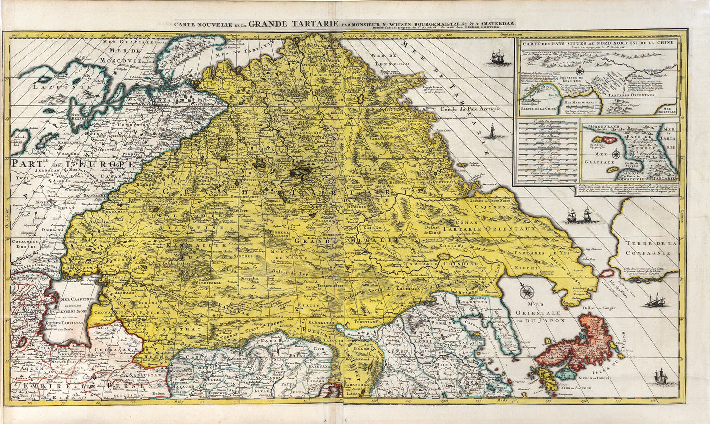
Pierre Mortier. Carte Nouvelle de la Grande Tartarie. 1700.
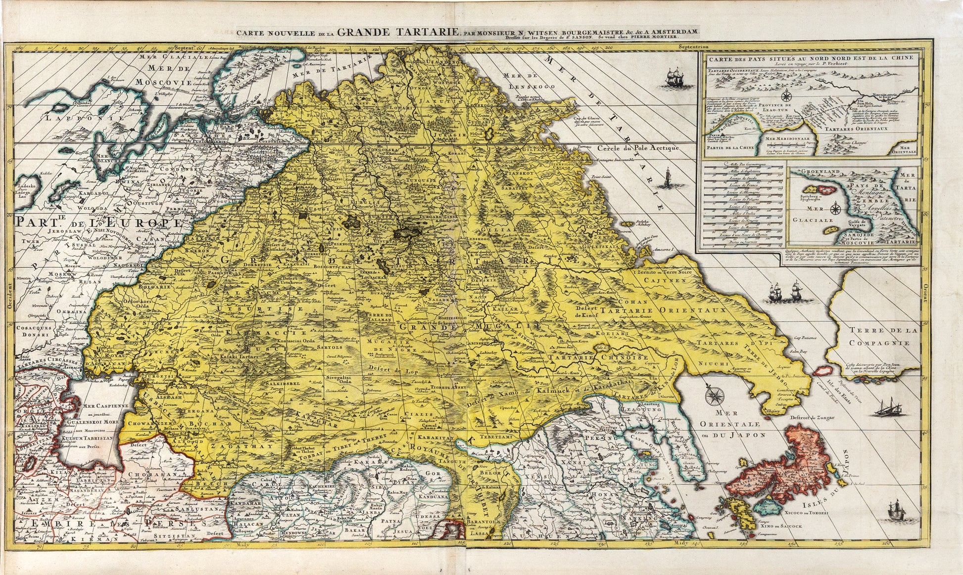
Pierre Mortier. Carte Nouvelle de la Grande Tartarie. 1700.
Couldn't load pickup availability
Pierre Mortier
Carte Nouvelle de la Grande Tartarie
Paris, 1700
24 ½ x 40 ½ inches
Highly Detailed Map of Tartary by Dutch Statesman and Russian Specialist Nicolaas Witsen with details from the Travels of Verbiest in China and De Vries in the North Pacific
Nice example of Pierre Mortier's decorative and detailed map showing Central Asia and Tartary published in Amsterdam.
The map extends from the Caspian Sea in the west and Nova Zemla in the northwest towards northern China, Korea and the islands of Japan in the southeast of the map. It was one of the most detailed regional maps to date.
The title emphasizes the area known as Grand Tartarie, or Great Tartary, a geographic entity referred to by cartographers from the Middle Ages to the early twentieth century. It stretched from the Caspian Sea and the Ural Mountains all the way east to the northern Pacific Ocean. The region was often split further into more local designations, as this map shows with Tartares Circasses and Tartarie Oreintaux.
Local towns and settlements are marked throughout the map with circles or small building symbols. Additionally, the area’s impressive geographic features are evident, especially the many mountains of the northeast, the forests of the north, and the deserts in southeast Grand Tartarie.
Korea is shown as a peninsula, while Japan is depicted as horizontal, a convention common to early modern maps. Interestingly, north of Japan is Terre de Jedso, connected as a peninsula to Tartarie Orientaux. Historically, Jedso (Eso, Yedso, Yesso) refers to the island of Hokkaido. It varies on maps from a small island to a near-continent sized mass that stretches from Asia to Alaska, but the peninsula form shown here is a rare construction of the feature.
Nicolaas Witsen, a specialist on Russia and its cartography
The map’s title explains that Nicolas Sanson set the map to degrees (although the attribution to Sanson is likely a ruse to get around the French privilege of Alexis Hubert Jaillot of Paris), but attributes the cartography to a Monsieur N. Witsen, Bourgemaistre. This refers to Nicolaas Witsen (1641-1717), a Dutch statesman and mayor of Amsterdam from 1682 to 1706. He was named ambassador extraordinary to the English court in 1689, where he became a Fellow of the Royal Society. He was also administrator to the Dutch East India Company (VOC) from 1693.
As his occupations suggest, Witsen was keenly interested in maritime affairs and he practiced cartography as part of his larger studies. He was also an expert in Russian affairs, having traveled there in the 1670s, which explains how he had the skill and knowledge to compile this map and others. In 1690, he published the first map of Siberia—a south-oriented map, as many Russian maps were at that time. Two years later, he produced a book called Noord en Oost Tartarye to accompany an earlier version of this map, first published in the late 1680s. After the privilege expired, it was reissued by Mortier.
Areas still to be discovered and Terre de la Compagnie
Several areas on the map are left blank or include notes suggesting they require further discovery. The northwest of Lapponie, or Lapland, is unfinished. Similarly, in the far northwest, Cap de Glaces is left open to the west, with a note explaining it, “has not yet been discovered.”
The map also includes the latest in geographic updates. Recent discoveries are marked with the tracks of voyages of discovery, including that of Martiniere in northern waters. This refers to Pierre Martin de la Martiniere, who published his account of travels in the far north as a ship’s surgeon in 1671.
To the far east, beyond the peculiar peninsular Terre de Jedso, is an especially interesting feature reflecting contemporary exploration, speculative geography, and the role of Witsen in studies of the far north. A large, blank landmass looms out of the right frame of the map labeled Terre de la Compagnie. A note along the southern coast explains that this coast was discovered by a Don Juan de Gama, and that the island ranges from China to New Spain. Separating the huge landmass from Jedso is a smaller island, Isle de Etats, and the Detroit de Vries. These place names suggest that Witsen has combined two popular tales of northern Pacific land sightings into a cohesive whole.
Juan, the grandson of Vasco de Gama, was a Portuguese navigator who was accused of illegal trading with the Spanish in the East Indies. De Gama fled and sailed from Macau to Japan in the later sixteenth century. He then struck out east, across the Pacific, and supposedly saw lands in the North Pacific. These lands were initially shown as small islands on Portuguese charts but they ballooned into a continent-sized landmass in later representations.
Several voyagers sought out de Gama’s lands, including the Dutchmen Matthijs Hendrickszoon Quast in 1639 and Maarten Gerritszoon de Vries in 1643. In the century after this map’s publication, Vitus Bering, a Danish explorer in Russian employ, and James Cook would both check the area and find nothing, finally putting to rest the myth of these land bridge islands. Witsen, however, was convinced the island existed, perhaps especially because he was given de Vries’ original expedition journal in 1692; it has not been seen since.
Here, Witsen mentions de Gama in a note, but the land is called Terre de Compagnie. Compagnies Land was one of two islands supposedly sighted by de Vries on his 1643 voyage. He named one island for the Dutch States General (Staten Land) and another for the Dutch East India Company (VOC) (Compagnies, or Company’s Land). In reality, he had re-discovered two of the Kuril Islands. However, other mapmakers latched onto Compagnies Land in particular. It is clear Witsen had de Vries and his voyage in mind, as a strait to the east of Compagnies Land is named Detroit de Vries.
Inset of Northern China and Ferdinand Verbiest
The map includes two insets in the upper right corner. The top inset offers a larger-scale look at the lands of Northeast China, near Peking. The details for this inset came from the voyage of P. Verbiest. Father, or Pere, Ferdinand Verbiest was a Jesuit missionary who served in China during the seventeenth century. A skilled astronomer, Verbiest demonstrated European astronomical methods to his Chinese hosts. Later, he was asked to rebuild and head the Beijing Ancient Observatory.
Like Witsen, Verbiest also practiced cartography as part of his intellectual agenda, in addition to writing over thirty books. He accompanied the Kangxi Emperor on many official trips around the empire, allowing him to more accurately know the geography of the region than any other European at the time. Verbiest’s best known cartographic work is the Kunyu Quantu world map of 1674.
The lower inset shows and discusses the possibility of new geographic configurations near Spitsbergen. Next to it is a comparative scale depicting twelve measurements from various countries and disciplines. Details like these mark this map as a highly intellectual product based on the latest and ongoing research. It was a product tied to several leading thinkers of the day from across Europe and was the most accurate depiction of the region to date.
Rarity
The map was not a standard inclusion in Mortier's atlases and is relatively scarce on the market.


