from: All Rare Books
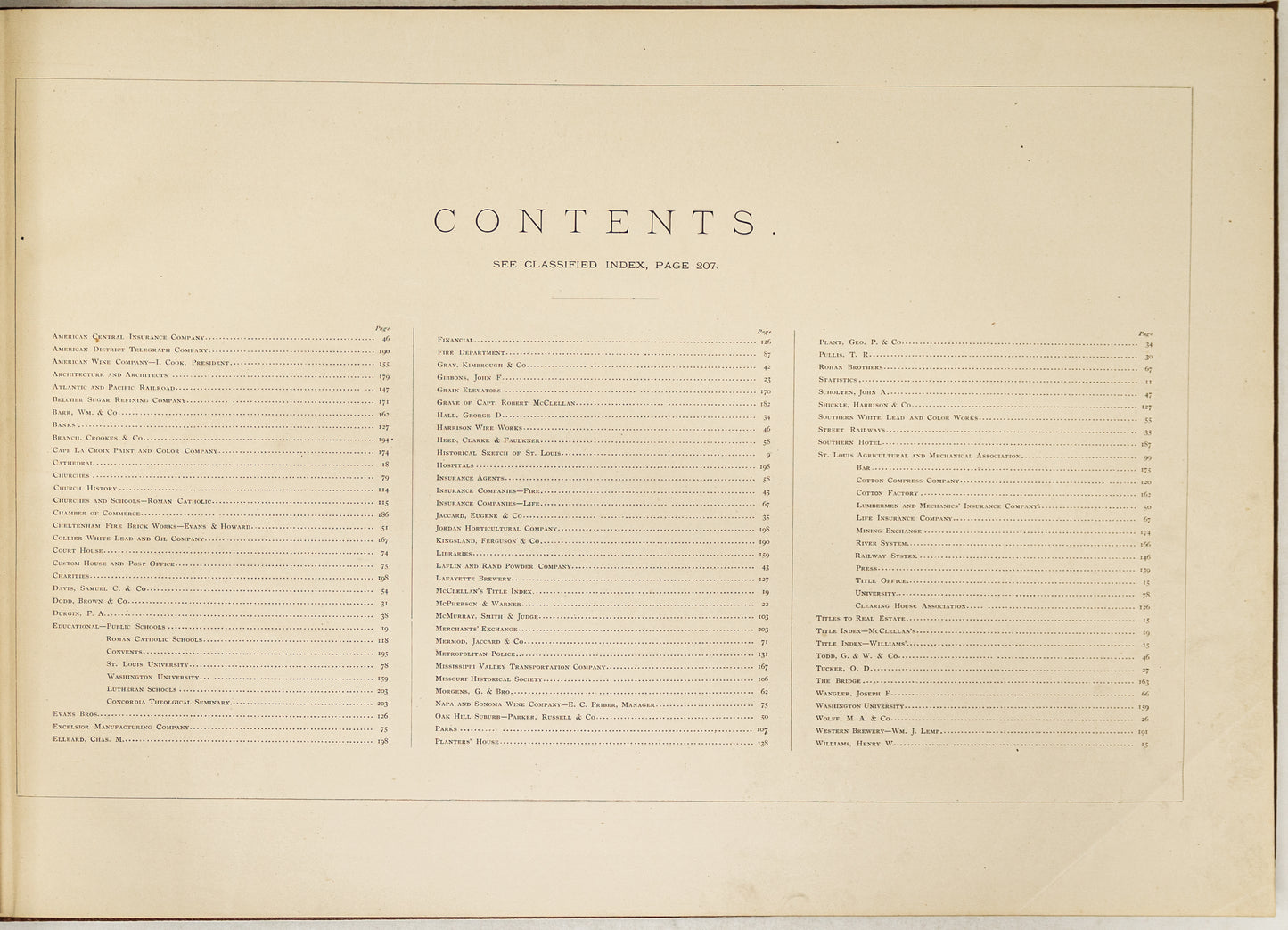
Pictorial St. Louis: The Great Metropolis of the Mississippi Valley. A Topographical Survey Drawn in Perspective A.D. 1875.
Pictorial St. Louis: The Great Metropolis of the Mississippi Valley. A Topographical Survey Drawn in Perspective A.D. 1875.
Regular price
$ 45,000.00 USD
Regular price
Sale price
$ 45,000.00 USD
Unit price
per
Couldn't load pickup availability
Pictorial St. Louis: The Great Metropolis of the Mississippi Valley. A Topographical Survey Drawn in Perspective A.D. 1875.
DRY, Camille N.
Published by St. Louis: Compton & Company, 1876., 1876
Oblong folio (14 x 20 4/8 inches).
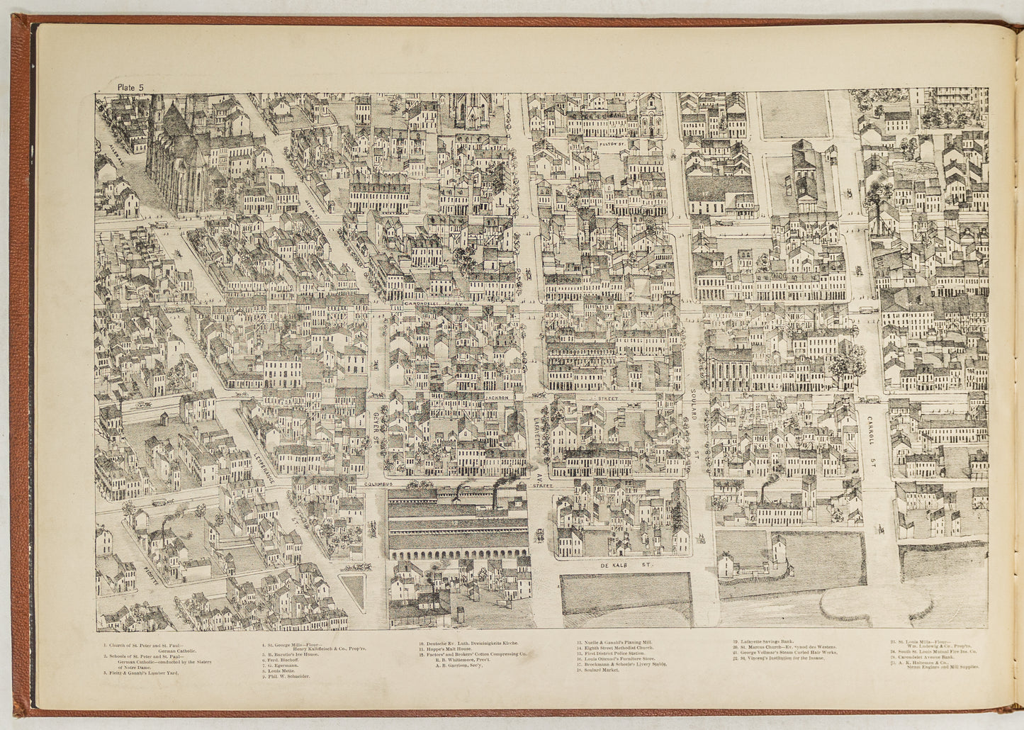
FINE Lithographed frontispiece, title-page, full-page key map, view, and 110 lithographed plates, most of which are included in the pagination, by Camille N. Dry (some light marginal thumbing to early leaves). Original ochre bevelled pebbled cloth handsomely decorated in black, gilt, and blind, all edges gilt; contemporary marbled paper board slipcase (a bit worn). Provenance: A FINE PRESENTATION COPY, inscribed by the designer and editor "To my friend Andrew Wanock. Esq with kindest regards Rich. J. Compton" on the title-page; with the signed bookplate of Bruce McKinney loosely inserted, his sale, 2nd December 2010, lot 302. First edition, RARE, AND AN EXCEPTINALLY FINE BRIGHT AND ATTRACTIVE PRESENTATION COPY.
An impressive and ambitious 110-sheet view of St. Louis from the southeast. "The publication is a tour de force. The detail is minute. Drawing the hundreds of structures in the business district alone at this scale and with such apparent accuracy would have been an accomplishment beyond any reasonable expectation" (Reps). The text includes a rich history of the city, minute descriptions of the buildings and businesses pictured, and the people associated with them. A comprehensive index is available online at http://genealogyinstlouis.accessgenealogy.com/1875index.htm. "The preliminary drawings for this work were made early in the spring of 1874. After a careful consideration of the subject, it was determined to locate the point of view so that the city would be seen from the southeast, believing that to be the most advantageous in all respects. Accordingly, the point of sight was established on the Illinois side of the river, looking to the northwest, and at sufficient altitude to overlook the roofs of ordinary houses into the streets. A careful perspective, which required a surface of three hundred square feet, was then erected from a correct survey of the city, extending northward from Arsenal Island to the Water Works, a distance of about then miles on the river front; from the Insane Asylum on the southwest to the Cemeteries on the northwest. Every foot of the vast territory within these limits has been carefully examined and topographically drawn in perspective". St. Louis came to the attention of the American public as the town from which Lewis and Clark began their exploring expedition. It was incorporated as a city in 1823, and became an important center of commerce and trade, attracting so many immigrants that between 1840 and 1860 the population exploded. As a strategic location during the Civil War St. Louis stayed firmly under Union control, but no major battle was fought in or near the city. Shortly after the survey on which these plates are based St. Louis established its current boundaries in 1876, when voters approved separation from St Louis County and the establishment of a home rule charter. Howes C655; Reps Views 12.