from: 1016 Map Inventory
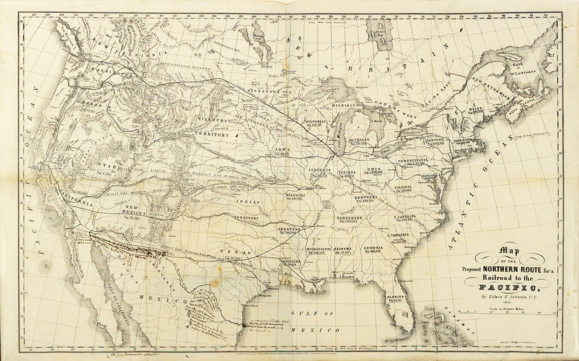
Johnson, Edwin F. Map of the Proposed Northern Route for a Railroad to the Pacific. Hartford, CT, 1853.
Johnson, Edwin F. Map of the Proposed Northern Route for a Railroad to the Pacific. Hartford, CT, 1853.
Couldn't load pickup availability
Edwin F. Johnson
Map of the Proposed Northern Route for a Railroad to the Pacific
Hartford, CT, 1853
35" x 22"
Highly detailed railroad map of the United States, illustrating a number of different proposed Northern Routes for a railroad line to the Pacific, by Edwin F. Johnson, C.E.
Johnson's map is one of the most interesting and important early maps to illustrate the prospective routes to the Pacific: As noted by Wheat:
This is in many ways an extraordinary map. . . It has the routes of Lewis and Clark, Fremont and Emory well drawn, and its showing of the general features of the topography is also excellent, considering the time of its preparation.
Johnson's map shows hydrographical features, state boundaries, major cities, and names of states, with state population figures. Western states show topography by hachures. Some major rail lines are shown in the northeastern states. Besides the "Northern Route" the map also indicates four more southerly proposed routes west of the Mississippi River.
The map appeared in Poor's Railroad Journal in 1853 and in Johnson's Railroad to the Pacific, Northern Route, Its General Character, Relative Merits, etc., published in New York in 1854. Graff notes that the work provides a good summary of ideas about the Northern Route, at a time when the concept and route was still very much in its earliest planning stages.
Johnson was a well respected civil engineer, who would later serve as chief of engineering for the construction of the Northern Pacific. His survey of the prospective routes is one of the most detailed and well regarded works issued before the Railroad Surveys. There is much information on the terrain of the proposed route, the findings of earlier explorers, climate, soil, etc. Projected railroad routes are shown on the maps, with possible routes outlined.
Other than the present example, as of 2012, Americana Exchange reports that the map has appeared at auction only once in the past 85 years (Swann Galleries, 2009, Sale 2183, Lot 87: $1,320) and prior to that at the Braislin Sale, Anderson Galleries 1927, where it was referred to even then as "Very Rare."
