from: Encounters and Empires: Africa, America, and the Early Modern World
Francis Daniel Pastorius, Manuscript Plan of Germantown, Pennsylvania (ca. 1686–1687)
Francis Daniel Pastorius, Manuscript Plan of Germantown, Pennsylvania (ca. 1686–1687)
Couldn't load pickup availability
This manuscript map is the original plan of Germantown, drawn by Francis Daniel Pastorius, founder of the settlement and an early advocate for human rights in colonial North America. Created soon after Germantown’s establishment, it records boundaries, natural features, and early lot divisions, providing a rare, close view of community formation in the late seventeenth century.
The work is closely associated with Germantown’s early tradition of ethical reflection, including the 1688 petition that opposed slavery. As an object of documentary and historical importance, it is among the earliest surviving American town plans.
- Medium: Ink manuscript on paper
- Date: ca. 1686–1687
- Sheet size: 15 11/16 × 9 15/16 in
Francis Daniel Pastorius
Manuscript plan of Germantown, Pennsylvania
with manuscript descriptions
THE ORIGINAL PLAN OF GERMANTOWN
THE CRADLE OF GERMAN AMERICAN IMMIGRATION
Germantown, Pennsylvania: approximately 1686 to 1687
Scale approximately 1 inch to 1000 feet
Broadsheet document
Sheet size: 15 11/16 x 9 15/16 inches, or 399 x 253 mm
Frame size: 20 3/8 x 14 11/16 inches
The map and annotations appear on the front side
A detailed description of the settlement appears on the back side
All elements are written in ink
The document shows three original folds creating eight separate panels. The folds produced some splits and small losses, and careful repairs improved those areas. The paper displays scattered browning and minor bleed through from the ink. Small pinpricks indicate that the sheet was prepared for copying. The sheet is fully matted and framed, and the back side is glazed so the manuscript text remains visible.
Franz Daniel Pastorius was born in 1651 in Sommerhausen in the Duchy of Franconia, located within modern Bavaria, Germany. He earned a Doctorate in Law in 1675 and practiced and taught law for several years. In 1680 he traveled abroad, including to England. After returning home in 1682, he learned about the early Christian communities that William Penn established in Pennsylvania. The new colony promised tolerance, religious freedom, and economic opportunity. Pastorius immigrated to the New World and landed there on August 16, 1683.
Pastorius quickly formed a strong friendship with William Penn himself. A note written by Pastorius on the right side of the map refers to Springfield, which he identifies as the manor of William Penn. Penn represented the ideal of religious tolerance. Pastorius represented the ideal of opposition to slavery. Together they illuminated the early Commonwealth of Pennsylvania with principles that shaped the future of the region.
Pastorius purchased land from Penn north northwest of Philadelphia and created Germantown as a planned settlement for German, Dutch, and Swiss immigrants from the Rhine Valley. The town welcomed many Protestant denominations, including Lutheran, Mennonite, Quaker, Pietist, Brethren, and others. In 1688 the Germantown Quakers produced the first organized American petition condemning slavery, known as the Germantown Quaker Petition Against Slavery.
The present item is the original manuscript town plan of Germantown drawn in the hand of Pastorius himself. Additional text appears in a second hand, possibly added by a clerk or assistant. The plan ranks among the earliest surviving American town plans and stands as an unparalleled historical source.
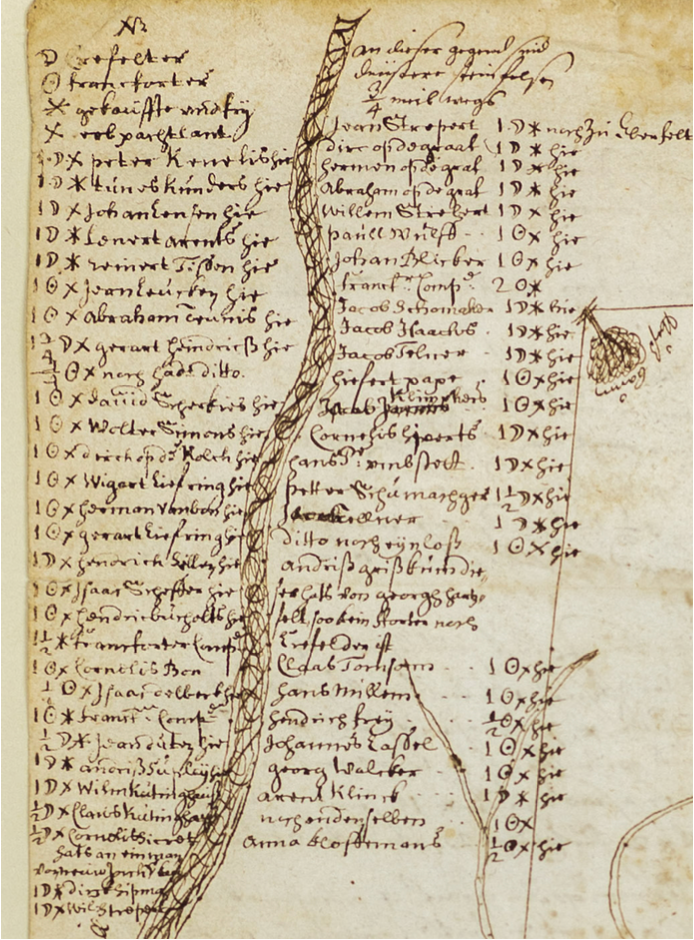
The map is oriented with Southwest at the top. It clearly shows the local river system, including the Schuylkill River to the Southeast and its tributaries. It outlines the measured boundaries of the Germantown settlement. Trees of different species mark the corners of the property. Those species include walnut, ash, Spanish oak, and white oak. Roads and internal lot boundaries appear within the plan as well.
The lot holders appear by name in the upper right corner. Their names follow the spatial order of the lots. Notes beside each name indicate whether the person lived in Germantown or remained in Europe. Duffin dates the map itself to late 1686 or early 1687 based on the arrival dates of the known settlers. Marginal notes at the bottom record later events in the town, including the election of Pastorius as mayor in July 1688.
The back side of the sheet contains a 35 line manuscript description headed Situation of Germantownship in Pennsylvania, Six English Miles from Philadelphia. Pastorius originally calculated the size of the township as 5,190 acres. A resurvey conducted from December 29, 1687 into January 1688 increased the total to 5,700 acres. Pastorius describes the location of Germantown in relation to nearby natural landmarks and nearby settlements. He also lists the original landowners, their origins, hereditary rights, and the extent of their individual holdings.
This map belonged to Samuel Whitaker Pennypacker, Governor of Pennsylvania from 1843 to 1916. Pennypacker enthusiastically collected historical Pennsylvania documents. He reproduced the map as illustration 104 in his 1899 book Settlement of Germantown. The reproduction carried the notation From the original in the library of the Author. Later auctions dispersed large portions of his collection between 1905 and 1909. The present item does not appear in those auction catalogs.
A note attached to the back of the frame claims that the map was possibly the personal copy of William Penn. That claim remains difficult to assess with confidence.
Reference
James M. Duffin
The First Map of Germantown, A Neglected Source
The Germantown Crier
Volume 44, Number 2
Fall 1992
Pages 4 to 17.