from: Maps of South America
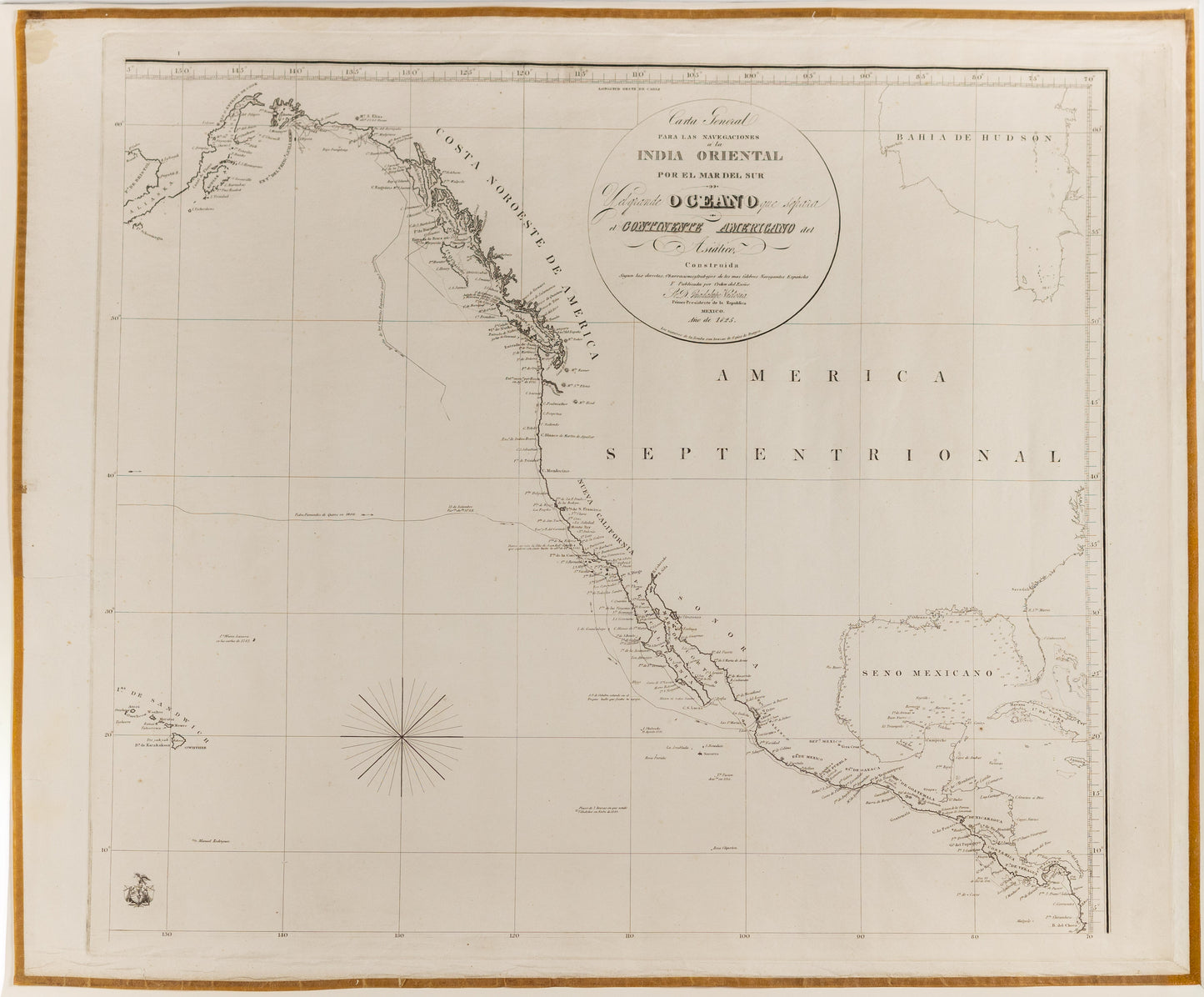
ESPINOSA Y TELLO, José de (1763–1815). Carta General para las Navegaciones a la India Oriental por el Mar del Sur...
ESPINOSA Y TELLO, José de (1763–1815). Carta General para las Navegaciones a la India Oriental por el Mar del Sur...
Couldn't load pickup availability
ESPINOSA Y TELLO, José de (1763–1815).
Carta General para las Navegaciones a la India Oriental por el Mar del Sur y el
Grande Océano que separa el Continente Americano del Asiático, construida según
las derrotas, observaciones y trabajos de los más célebres navegantes españoles, y
publicada por orden del Exmo. Sr. D. Guadalupe Victoria, Primer Presidente de la
República.
Mexico City: República Mexicana, 1825.
Engraved hydrographic chart. Separately issued. First Mexican edition.
A rare and highly important Mexican sea chart of the Pacific, published in Mexico
City in 1825 by order of Guadalupe Victoria, the first president of the newly independent Mexican Republic. This remarkable chart records the Pacific coast of the Americas, extending from Central America and Mexico northward along Alta California, the Northwest Coast, British Columbia, Alaska, and across the North Pacific toward the Hawaiian Islands. It was intended not as a decorative map, but as a working navigational chart for voyages across the “Mar del Sur” and the great ocean separating America from Asia.
The chart is the first Mexican edition of José de Espinosa y Tello’s great Pacific
chart, first issued in London in the 1810s. Its title makes clear that it was compiled
from the routes, observations, and labors of the most celebrated Spanish navigators.
In this sense, it is one of the most eloquent cartographic survivals of the Spanish
hydrographic tradition in the Pacific — a tradition built from the voyages of
Malaspina, Galiano, Valdés, and other Spanish naval explorers whose work defined
the mapping of the Pacific coast at the close of the eighteenth century.
Its publication in Mexico in 1825 gives the chart exceptional historical resonance.
Only a few years after independence, the new Mexican Republic republished a great
Spanish imperial navigation chart under its own authority. The map therefore
stands at a fascinating political and scientific threshold: it is at once a product of
Spanish naval science and an assertion of Mexico’s inherited command of Pacific
geography. Guadalupe Victoria’s name in the title is especially significant, placing
the chart among the earliest major cartographic publications of independent
Mexico.
The chart relates closely to the world of the 1802 Relación del Viage hecho por las
Goletas Sutil y Mexicana, the celebrated text and atlas concerning the Spanish
reconnaissance of the Strait of Juan de Fuca, Nootka Sound, Vancouver Island, and
the Pacific Northwest. That work, generally associated with Martín Fernández de
Navarrete and often attributed to José de Espinosa y Tello, records one of the most
important Spanish expeditions to the Northwest Coast and preserves the maps,
plans, and ethnographic plates resulting from Spain’s late eighteenth-century
exploration of the region. The present 1825 chart is not part of that publication;
rather, it belongs to the same hydrographic tradition on a grander Pacific scale.
Where the Sutil y Mexicana atlas focuses on the Northwest Coast and the Spanish response to British and Russian activity, this chart broadens the field to the whole navigational world of the eastern Pacific and the routes toward Asia.
A major survival from the scientific mapping of the Pacific, this chart is especially
desirable for collections devoted to Spanish exploration, Pacific navigation, the
Northwest Coast, California, Mexico, and the cartographic formation of the modern
Pacific world.