Arnoldo di ARNOLDI (d. 1602). Universale descrittione... 1634
Arnoldo di ARNOLDI (d. 1602). Universale descrittione... 1634
Couldn't load pickup availability
Arnoldo di ARNOLDI (d. 1602)
Universale descrittione del mondo
Siena: Giovanni Florimi, 1634
Second issue
Two sheets (Sheet: 32 1⁄4” x 20 3⁄8”, framed: 39 3⁄4” x 28 1⁄2”)
Engraved, with original hand-coloring.
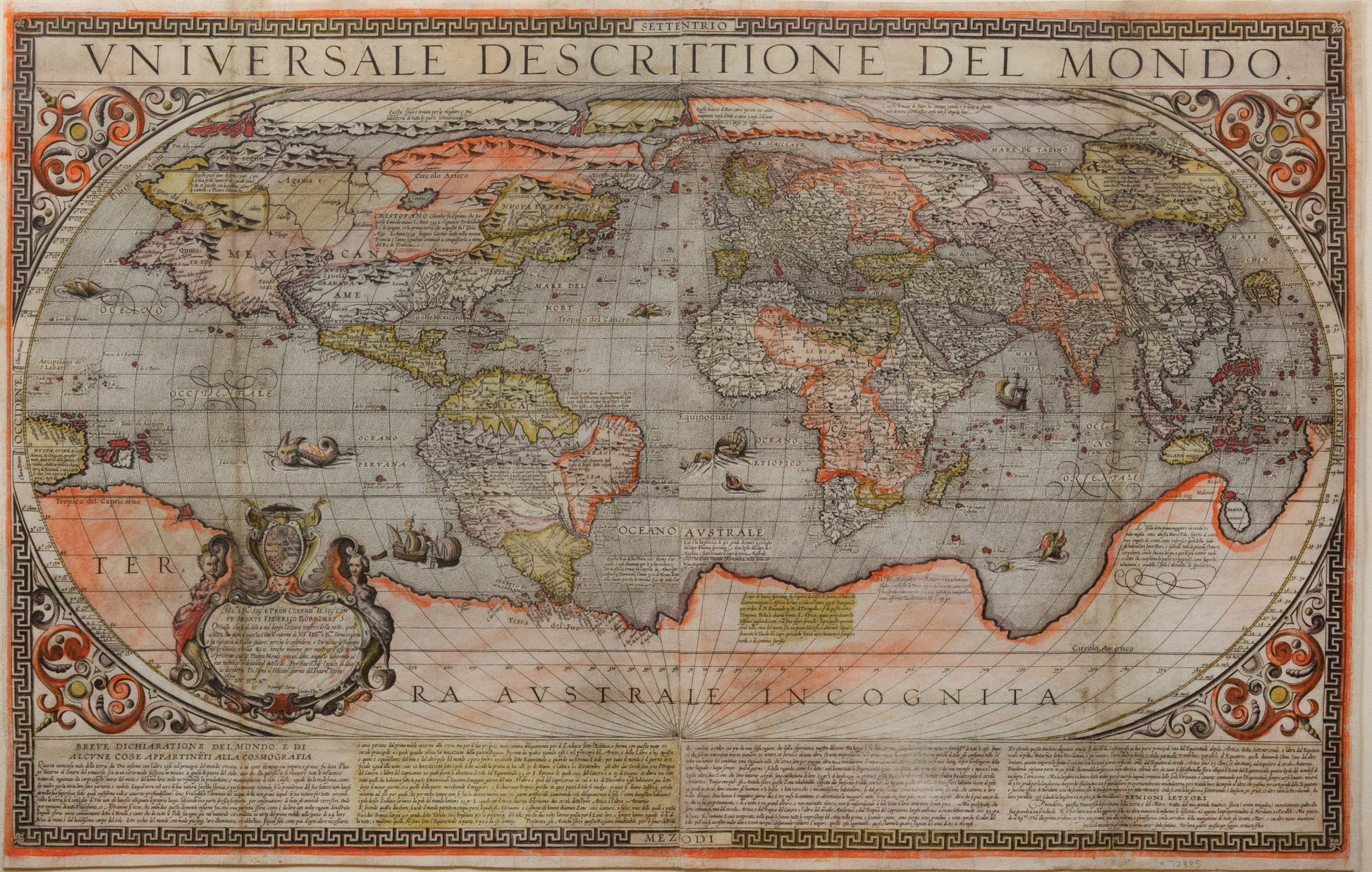
A stadium map of the world, with scrollwork in the corners. The whole is surrounded by a white-on-black heraldic meander. At the top, the title. At the bottom, a description in four columns. At the lower left of the map, a cartouche with the arms of Federico Borromeo (il Giovane). Backed onto a sheet, evening out some irregular margins. Two vertical lines of soiling from earlier folds. Two areas restored in facsimile: ONDO in the title with its corresponding border, and a triangular section north of China centered on Tanguth. Some small patches of abrasion, but altogether in excellent shape, and with vivid original hand-color.
Map historians refer to a group of loosely organized map makers active in 16th century Venice as the “Lafreri School.” The Lafreri School takes its name from Antonio Lafreri (1512–1577), a Burgundian cartographer-engraver who settled in Rome and who popularized the creation of composite atlases. Lafreri School maps represent the high-water-mark of Italian cartography before the center of mapmaking moved north to the Netherlands.
Arnoldo di Arnoldi (d. 1602) was a Belgian transplant to Italy. He went to work for Matteo Florimi (1540–1615), whose son Giovanni continued the business after his death as Eredi Florimi (Florimi’s Heirs). Arnoldi brought influences from further afield to Italian mapmaking; his 1600 map is clearly derived from Petrus Plancius’ 1592 eighteen-sheet cylindrical map (which survives in a single copy at the Colegio del Corpus Christi in Valencia). In 1600 Arnoldi drew a very large ten sheet map derived from Plancius’ large scale work,using the same planospherical projection and making minor revisions to the cartography, particularly on the coasts of North and South America. He translated the text, however, and recast the map with a distinct and elaborate Italianate style.
In 1601, he reduced the map to two sheets. The present map is the second state of his 1601 two-sheet map (of which Bifolco-Ronca cites only five copies). The original state was dedicated to Cristoforo Chigi, the 1634 state to Federico Borromeo (1617–1673), who in that year (at the age of 17) received his doctorate in civil and canon law from the University of Siena.
The two sheet map is recast as an oval projection instead of the original planospherical one used on the larger map. The decorative elements are also restrained compared to the larger map, but the map still presents as highly decorative in the Italian style. Extensive textual notations fill the map with historical and geographical information. Cartographically, the map shows elements derived from Plancius and from Mercator and others. It includes a prominent passage across North America to the Strait of Anián, the hypothesized precursor to the Bering Strait. The map shows Lake Conibas, a clustered lake generalizing the Great Lakes, drawn from Mercator’s 1569 map. The North Pole is in four islands, and there is a magnetic node near the Strait of Anián, which is perhaps an early explanation of magnetic variance.
Most striking is the Terra Australe Incognita that fills nearly half of the southern hemisphere. It is connected to the southern tip of South America in the western hemisphere and joins to Giava Minore (i.e., Sumatra), which had been mentioned
by Marco Polo and erroneously positioned on maps for centuries by scribal error; the connection of Sumatra to the terra australis was made by Jean Alfonse in 1544 and persisted into the 17th century despite exploration by Janszoon and others.
References: Shirley 228. Bifolco-Ronca, pp.296–297.
