Skip to content
Subscribe to our mailing list
Engravings & Lithographs
Engravings & Lithographs
Birds/Ornithology
Botanical
Fish & Reptiles
Mammals
Ethnographic
Views & Exploration
U.S. City Views
Architectural Views
College Views
Maps
Maps
Africa & Middle East
Americas
Americas
United States & Mexico
West Indies
South America
Asia
Australia & Oceania
Celestial
Europe
Globes
Sea Charts
World Maps
Polar
Audubon
Audubon
The Birds Of America, Havell Edition
The Birds Of America, Octavo Edition
The Quadrupeds of North America, Octavo Edition
The Quadrupeds of North America, Folio Edition
Paintings & Watercolors
Paintings & Watercolors
Paintings
Paintings
All Paintings
Marine
Botanical
Western
Landscape & City
Watercolors
Watercolors
Botanical Watercolors
Ornithological Watercolors
Charles Huard: New York
Curated Collections
Curated Collections
Maps of America
Best of the West
The Roots of Texas
Dinosaurs and Evolution: Original Artwork
The Greatest Bird Books in the World
Canada's Audubon
The Royal Treatment
Gobelins Tapestries
Art in the Age of Medici
Hand Carved Gilt Wood Frames
The Finest Corpus of 18th and 19th century Watercolors Relating to South America Extant
A Monumental Pacific Panorama: Five Grand Decorative Panels After Cook’s Voyages
Speak to a Curator
Engravings & Lithographs
Birds/Ornithology
Botanical
Fish & Reptiles
Mammals
Ethnographic
Views & Exploration
U.S. City Views
Architectural Views
College Views
Maps
Africa & Middle East
Americas
United States & Mexico
West Indies
South America
Asia
Australia & Oceania
Celestial
Europe
Globes
Sea Charts
World Maps
Polar
Audubon
The Birds Of America, Havell Edition
The Birds Of America, Octavo Edition
The Quadrupeds of North America, Octavo Edition
The Quadrupeds of North America, Folio Edition
Paintings & Watercolors
Paintings
All Paintings
Marine
Botanical
Western
Landscape & City
Watercolors
Botanical Watercolors
Ornithological Watercolors
Charles Huard: New York
Curated Collections
Maps of America
Best of the West
The Roots of Texas
Dinosaurs and Evolution: Original Artwork
The Greatest Bird Books in the World
Canada's Audubon
The Royal Treatment
Gobelins Tapestries
Art in the Age of Medici
Hand Carved Gilt Wood Frames
The Finest Corpus of 18th and 19th century Watercolors Relating to South America Extant
A Monumental Pacific Panorama: Five Grand Decorative Panels After Cook’s Voyages
Speak to a Curator
Search
Cart
Item added to your cart
View my cart
Check out
Continue shopping
Collection:
United States
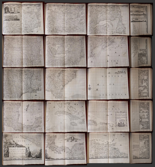
Henry Popple. Map of the British Empire in America. 1740.
Henry Popple. Map of the British Empire in America. 1740.
Regular price
$ 255,000.00 USD
Regular price
Sale price
$ 255,000.00 USD
Unit price
/
per
Choosing a selection results in a full page refresh.
Opens in a new window.