from: Maps
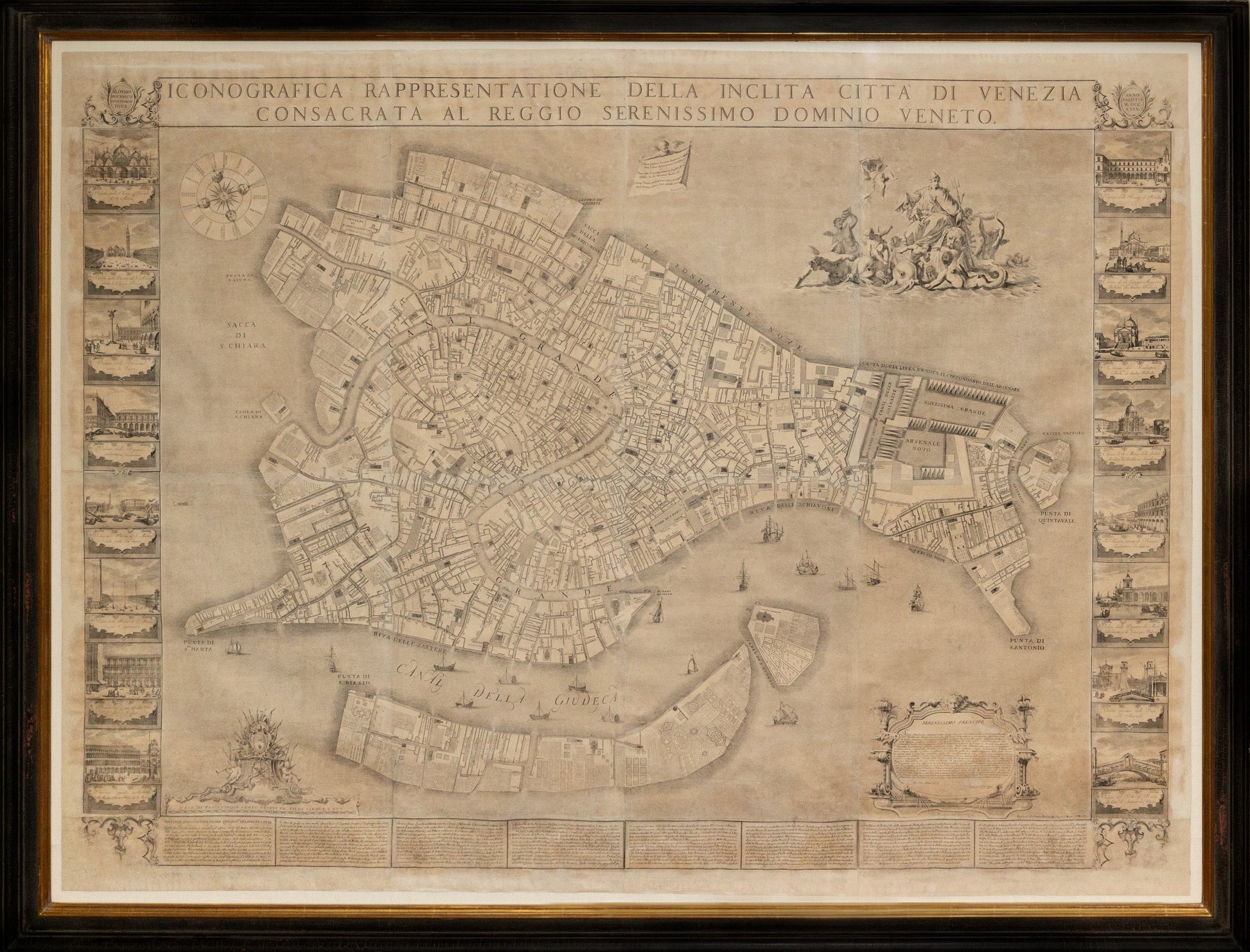
Ughi, Ludovico (fl. 1700-1740). [Venice] Iconografica rappresentazione della inclita citta di Venezia consacrata al reggio serenissimo domino veneto. Venice: 1703.
Ughi, Ludovico (fl. 1700-1740). [Venice] Iconografica rappresentazione della inclita citta di Venezia consacrata al reggio serenissimo domino veneto. Venice: 1703.
Couldn't load pickup availability
Ludovico Ughi (fl. 1700-1740)
[Venice] Iconografica rappresentazione della inclita citta di Venezia consacrata al reggio serenissimo domino veneto.
Engraved map
Venice: 1703 (Second State, 1739)
74" x 83" sheet, 82" x 91" framed
Of Lodovico (Ludovico) Ughi, nothing but his authorship — or at least his dedication — of the present map is known. He signs his inscription as a “Kavalier,” i.e., a cavaliere (knight; this is the only rank) of the Ordine di San Marco. Some sources claim that he was from Bologna or from Ferrara.
His map, however, has gained everlasting fame as the epochal and defining depiction of La Serenissima. Depictions of Venice have a long history, but Ughi’s 1729 plan is based on a re-surveying of the city — no easy task in a swamp — and underlaid depictions of the city well into the XIXc.
Composed from 20 sheets, the vast map (nearly 7 feet wide) is flanked by 16 vignettes engraved by Francesco Zucchi after Luca Carlevarijs (1663–1730) and surmounts eight columns of text detailing the principal sites and structures of the city. At the top-right is an allegorical scene (after Sebastiano Ricci) of La Serenissima atop the lion of Saint Mark, borne by dolphins and escorted by putti, tritons and mermaids. At the upper edge, a putto holds a banner on which is a poem of Sannazaro, “Viderat Adriacis Venetam Neptunus in undis/ stare urbem…” (Neptune had seen Venice, a city standing in the Adriatic waves…) published in 1535. At the bottom left are the arms of the Mocenigo family,[1] which supplied seven doges; the doge at the time of the original plate (the only difference between the first state and the present is the alteration of the publisher at lower right, from Giuseppe Baroni to Lodovico Furlanetto) was Alvise III Sebastiano Mocenigo (1662–1732; r. 1722–1732).
The date of the map is based on Moretto, who gives no explanation. Schulz, citing Gallo, asserts that the map’s “plates were acquired by Furlanetto before 1779, when they were listed as part of his stock.” 1739 is certainly a more plausible date.
Moretto, Gino (ed.). Venetia: le immagini della Reppublica. Padova: Papergraf, 2001; 152.
Schulz, Juergen. “The printed plans and panoramic views of Venice (1486-1797)”. No. 117.
![Ughi, Ludovico (fl. 1700-1740). [Venice] Iconografica rappresentazione della inclita citta di Venezia consacrata al reggio serenissimo domino veneto. Venice: 1703.](http://aradernyc.com/cdn/shop/files/JLR0424_1.jpg?v=1754082357&width=1445)