from: Maps
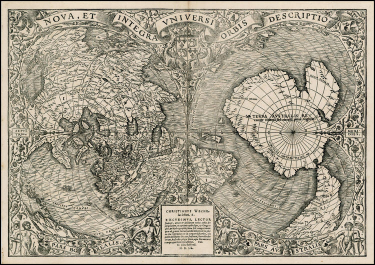
ORONCE FINE. Nova, Et Integra Universi Orbis Descriptio. Paris, 1541.
ORONCE FINE. Nova, Et Integra Universi Orbis Descriptio. Paris, 1541.
Couldn't load pickup availability
Oronce FINE (1494-1555)
Nova, et Integra Universi Orbis Descriptio
Paris: Christianus Wechelus, 1541
Sheet: 11 2/8” x 16 2/8” to the neat line, framed: 24” x 28 4/8”
Single sheet, matted and framed
Woodcut double-cordiform world map, the title within a ribbon banner along the top edge, Wechelis’ imprint centre lower edge, showing the world in two hemispheres, the right being mostly “Terra Australis’, ‘recently discovered, but not yet explored’ and South America, the left, Europe and North America, surrounded by an elaborate decorative border.
Provenance: The Goodyear Collection, purchased September 1984, their sale Rachel Davis Fine Arts, September 21st, 2013, lot 477.
Europeans were intensely interested in the process of exploration and discovery as it occurred in the early 16th Century. In 1531 Johann Huttich and Simon Grynaeus published “Novus Orbis Regionum ac insularum veteribus incognitarum,” an extraordinary collection of accounts of voyages of discovery to the Americas, Asia and Africa by Columbus, Vespucci, Pinzon, and others. The work was published in Basel and in Paris. The Paris edition contained a superb double cordiform world map by the French cartographer Oronce Fine (1494-1555).
Born in Briançon, the son and grandson of physicians, Fine was educated in Paris (Collège de Navarre), and obtained a degree in medicine in 1522. In 1531, he was appointed to the chair of mathematics at the Collège Royal (the present Collège de France), founded by Francis I of France, where he taught until his death. As well as being a fortifications expert (he worked on the fortifications of Milan), Fine was a noted astronomer and cartographer. He invented the cordiform or heart-shaped map, frequently utilized by other cartographers.
Fine’s map was the finest rendering of the world up to its date, although it retained the connection between North America and Asia that was seen in the Contarini-Rosselli map of 1506 and Ruysch of 1507. However, the monumental discoveriesm made since the creation of these maps, which forever altered the coastlines, find a place on Fine’s map. The map extends the eastern coast of North America southward beyond the discoveries of Gomes and Ayllon to a peninsular outline of Florida, which is named, and a reasonable depiction of the Gulf coast as described by Pineda in 1519. This is the earliest recognizable depiction of a continuous east coast of North America on a printed map. The South American continent is also admirably depicted, incorporating discoveries by the Portuguese and by Ferdinand Magellan. Central America contains numerous place names reflecting conquests and explorations. The isthmus of Darian is shown and named, as well as the “Mare magellanicum” (Pacific Ocean), one of the first uses of the navigator’s name in such a context. The west coast of Mexico, although continuous with Asia, is the earliest record on a printed map of the discoveries of Hernando Cortes. “Terra Australis” (Australia) fills much of the right-hand (or southern) cordum and is marked as being ‘recently discovered but not yet explored.’ The north pole is indicated by four islands and the separate island of Greenland is named. Fine’s highly detailed woodcut map is surrounded by floral embellishments, two mermaids, two muscular cherubs, the French royal coat of arms and, at the head of the map, the title in a flowing banner.
Fine’s cartographic findings were hugely influential to the history of mapping and were followed by Gerard Mercator for his important world map of 1538, and for the copies by Antonio Salamanca (ca. 1550) and Antonio Lafreri (ca. 1564).
References: Shirley 66. Harrisse 197. Sabin 34101. Nordenskiold pp. 74 (note), 90, 106 and plate XLI(2)
