from: Maps
COUAGNE, Jean-Baptiste de (1687-1740). Nouvelle France. Canada: 1711.
COUAGNE, Jean-Baptiste de (1687-1740). Nouvelle France. Canada: 1711.
Couldn't load pickup availability
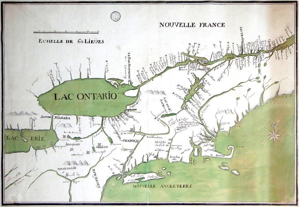
COUAGNE, Jean-Baptiste de (1687-1740). Nouvelle France. Canada: 1711.Single sheet (paper size: 19 x 27 ½ in.; 48.2 x 70 cm.); Framed size: 30 ¼ x 39 in.; 76.8 x 99cm). In pen and ink with green color wash; central vertical crease. THE FIRST MAP OF CANADA BY A CANADIAN CARTOGRAPHER ANDPRODUCED IN THE NEW WORLD. EXCEPTIONALLY FINE ORIGINALMANUSCRIPT MAP OF "NOUVELLE FRANCE". This unique and exquisitely rendered, large-scale original manuscript map shows Northeastern America (the Great Lakes, the St. Lawrence River and Nova Scotia).ONE OF ONLY FOUR KNOWN MAPS BY COUAGNE AND ONLY ONE IN NORTHAMERICA, THE REST HELD BY FRENCH LIBRARIES. This is the only map known to still be in private hands; the three others are held by the Bibliotheque Nationale de France(two) and the Bibliotheque du Service Historique de la Marine (one). Jean-Baptiste de Couagne was the first cartographer born in North America. A relatively low-ranking individual in the colonial regular force, he became a lieutenant in 1719 and a half-pay captain in 1732, the rank he held until the day he died. We are certain this was produced in mainland Canada because Couagne's movements are well documented, and we know he never left New France. F. J. Thorpe notes that Couagne "combined diligence with integrity, retaining a sense of objectivity during those personal and procedural wrangles which marked the tenure of Verville. The usefulness and devotion to service of Couagne were matters on which even bitter enemies could agree." His map of Nouvelle France is one of the first maps relating to the American Northeast drafted by a North American-born cartographer. Couagne was born to French parents, probably in Montreal in 1687, and he trained there as a draftsman and surveyor (DCB). Although he never received training in Europe, he eventually became one of the most accomplished mapmakers in the service of the French government. As an official map sponsored by the French government, the geographical information regarding Lakes Ontario and Erie was far superior to that of the enemy English, and even too much later maps such as Henry Popple's "Map of the Northern Colonies" (1733). In fact, it is much closer in detail to the highly sophisticated maps of five decades later, such as Lewis Evans "Map of the Middle British Colonies in America" (1755). In general, French mapping of the area delineated in Couagne's manuscript map was far superior to contemporary British cartography of the region. As demonstrated by late 17th-century maps done under the auspices of the French government by figures such as Louis Jolliet, La Salle, and Jean-Baptiste Louis Franquelin, the accuracy, precision, and detail of French cartography was unrivaled in this period. Relying heavily on the work of the Jesuits in New France, whose reach was extensive, cartographers and explorers consistently availed themselves of the local knowledge obtained by the missionaries. The cartographic competition that resulted from the British and French contest for colonial strongholds led to the production of remarkably sophisticated maps such as this one, which, never published in printed form, was jealously guarded by the French government for the crucial information it so masterfully delineated. Couagne's map of Nouvelle France represents a unique and valuable historic document: an illustration of the colonial forces at work in critical areas of Northeastern America, the best in contemporary cartography of that region, and an early and unique work by the first North American-born mapmaker. This map and the knowledge expressed in it were considered so sensitive that it was kept in the archives of the Depot DE Marine in Marseilles until the 1950s. At the time the French government considered that this proportion of their national archive was surplus to their holdings at the Bibliotheque Nationale, and the map was bought by a private individual, who subsequently sold it at Sotheby's in June2000. PROVENANCE: "Carte sous la Compagnie des Indes, du La Champlain et de Chouaquin" in manuscript on verso, stamp of the Dépôt de la Marine, Paris, late 1711-early 1712. Bookseller Inventory # 165B01Price: $15,000,000.