from: Americas
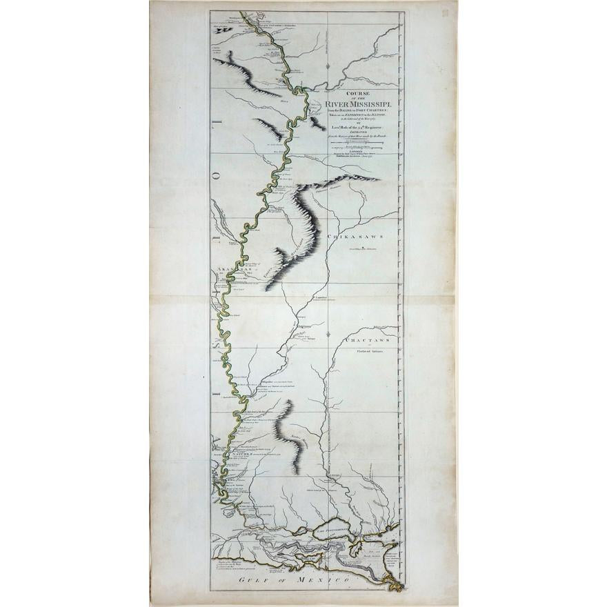
John Ross. Course of the River Mississippi. 1775.
John Ross. Course of the River Mississippi. 1775.
Couldn't load pickup availability
ROSS, Lieutenant John (1744-1809).
Course of the River Mississippi, from the Balise to Fort Chartres; taken on an expedition to the Illinois.
Engraved map with original hand color in outline.
London: Robert Sayer, 1 June 1775.
46" x 21 1/4" sheet.
An early map of the Mississippi River based on English sources, second issue with additions of Fort St. Leon and Fort St. Mary just south of New Orleans. Earlier English maps more generally focused on the Mississippi River valley rather than the river itself. Phillips Maps of America p. 439.
Condition: Top edge hinged to later paper panel with grommets, a few mild marginal stains.
The Most Influential Map of the Mississippi River on the eve of the American Revolutionary War.
Highly detailed map of the Mississippi River, from just north of the confluence of the Ohio River to the Gulf of Mexico, published by Thomas Jefferys in London.
Lieutenant Ross' large scale map of the Mississippi River is of the few large format maps of the Mississippi published during the 18th Century. Ross' map was the first official English survey of the Lower Mississippi, and one of the most historically significant American maps, delineating the British territorial gains following the French and Indian War and later establishing the future western boundary of the new United States. The map opened the area to settlement from the east and defined the western limits of the American colonies. It would also be an area of great intrigue in the years immediately following the publication of this map, as France and Spain both evaluated the prospects of extending and preserving their territorial claims in the region prior to the Louisiana Purchase.
Ross's map provides a large-scale depiction of the river and its topographical features, such as islands in the river, navigational instructions, other rivers and connecting tributaries, boundaries, towns and settlements, forts, local history (including the spot where De Soto discovered the Mississippi in 1541), quarries and potential mining areas, productive land, cane fields, and mountains and other topographical details. A number of Indian Tribes are shown, including the Flathead, Chactaw, Chikasaw, Chackhuma, "Akansas or the Handsome Men," Wyapes, Corrois, Yazous, Ofogoulas, Chepoussa, Caskaskias, Colapissas (later known as Huoma), and others. Frederick Webb Hodge (Handbook of American Indians North of Mexico) makes numerous citations to this map.
Following the Treaty of Paris, a British expedition was sent to the Illinois territory to demand the surrender of Fort de Chartres, the last outpost under French control in the area. Lieutenant John Ross, surveyor of the 34th Regiment of the British Army, went with this expedition and surveyed the lower part of the River, below Fort Chartres, to the mouth of the Mississippi River. While Ross was able to provide a good account of the Eastern Bank of the River, he was not able to land on the west bank, which was then claimed by Spain.
A nice example of this seminal collector's map of the Mississippi River.