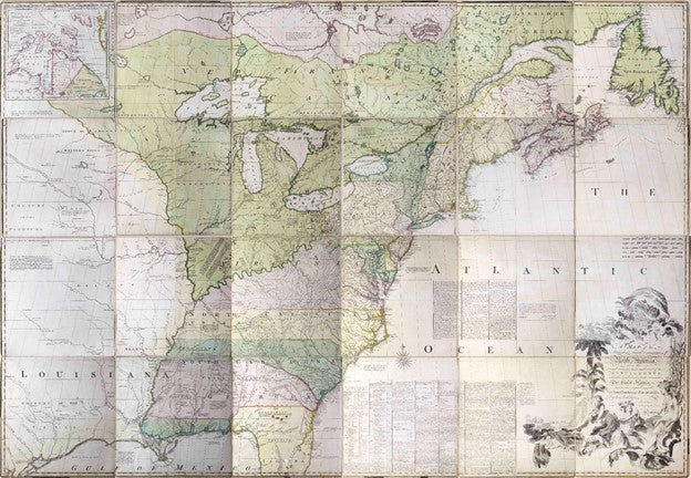
MITCHELL, John (1711-1768) A Map of the British and French Dominions in North America…1755
MITCHELL, John (1711-1768) A Map of the British and French Dominions in North America…1755
Couldn't load pickup availability
MITCHELL, John (1711-1768)
A Map of the British and French Dominions in North America…
Copperplate engraving with original hand color
London, 1755 (Third edition, first impression)
In 24 segments and mounted on linen, 53 x 77 inch total sheet
$700,000
Mitchell's monumental map both depicted and influenced the shaping of North America from the French and Indian War through American independence.
During the first half of the 18th Century France's conflict with England east of the Mississippi escalated rapidly. Maps like De L'Isle's 1718 map, and counter arguments by English mapmakers like Herman Moll, added to the tension. In 1756 war between the two nations broke out. The Seven Years War, called the French and Indian War in America, was global but the real prize was the Ohio Valley and the lands to the west of the Appalachians. The essentials of the conflict are seen in two editions of what has been called the "Most Important Map in American History," John Mitchell's Map of the British and French Dominions in North America.
The first edition of Mitchell's map was published in London in 1755, on the eve of the war. The map graphically presented the threat England perceived from French activity in the fertile lands between the mountains and the Mississippi. One subtle way Mitchell did this was to extend the name of French "Louisiana" east across the Mississippi, a geopolitical statement unlikely to be missed by his English audience. Echoing De L'Isle's technique four decades earlier, Mitchell bolstered his case for English ownership by identifying the valuable resources that lay in the disputed territories ("a country full of mines" for example) and by including historical references supporting England's territorial claims south of Virginia and west of the mountains.
The map was also filled with the names of over forty native American tribes, with the Iroquois highlighted in large letters across several English colonies. The “Six Nations” federation was by far the most powerful native tribe east of the Mississippi, and Mitchell’s map recognized their importance in the context of the English and French conflict.
When war broke out, many of the most powerful native tribes sided with the French. However, in 1758 a large contingent including many of the Iroquois switched sides in favor of the English. Seeing the possibility of an English victory, in 1762 France transferred Louisiana to Spain in order to keep it out of English hands. A secret treaty permitted France to reacquire the lands if it chose to do so.
The English prevailed in the war, and the Treaty of Paris in 1763 reshaped ownership of the continent. France lost all of its territorial claims east of the Mississippi. Spain’s interest in Louisiana west of the Mississippi plus New Orleanswas conceded by the English, but it gave up Florida, which the English divided into two parts: East Florida (east of the Apalachicola River) and West Florida, which included Spanish Florida west of the river plus some parts of modern day Louisiana, Mississippi and Alabama.
Following the British victory, relations between the crown and English colonists in North America deteriorated. One source was the English King's decree in 1763 prohibiting colonists from acquiring land from the Native American tribes. Although widely ignored, this decree was one reason that the American revolution was led by the colonial elite, who were frustrated in their attempts to expand to the west.
American victory in the revolution was memorialized in the Treaty of Paris of 1783. Britain retained its Canadian possessions but the rest of the continent east of the Mississippi and north of Florida formed the United States. The treaty was negotiated using the third edition of Mitchell's map, an example of which is in this exhibition. The negotiated border running through the center of Lake Ontario is painted on the map; the line was engraved for the publication of the subsequent edition.
During the war, Spain had attacked and taken West Florida from the British. Under the treaty, Spain was given East Florida in return for Britain keeping Gibraltar. With this acquisition, Spain at least nominally extended its empire from the Pacific Ocean through New Spain and New Mexico, through Louisiana and into Florida – from coast to coast!