Giovanni Paolo CIMERLINUS (1534/1535-1609 after) Cosmographia universalis ... 1566
Giovanni Paolo CIMERLINUS (1534/1535-1609 after) Cosmographia universalis ... 1566
Couldn't load pickup availability
Giovanni Paolo CIMERLINUS (1534/1535-1609 after)
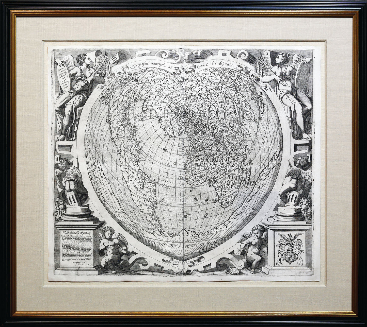
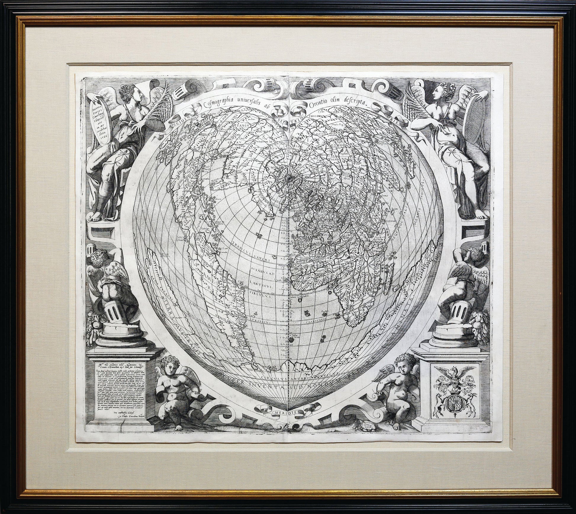
Cosmographia universalis ab Orontio olim descripta
Venice: Giovanni Paolo Cimerlinus, 1566
Sheet: 19 1/4” x 23”, framed: 30” x 33”
Engraved map with a dark impression
European cartography exploded in the latter half of the 16th Century as new discoveries were reported from voyages throughout the world. Technology helped, with copper plate engraved maps superseding woodcuts, particularly in Italy. David Woodward has estimated that over 900 different copper plates were being used in Venice and Rome alone to print maps during this period. The explosion of information led to early attempts to assemble collections of maps that, together, covered the known globe. The maps were not necessarily made to go together, in scale or appearance, but they were the early precursors of the modern atlas.
Among the finest world maps found in any composite atlas is Cosmographia universalis ab Orontio olim descripta by Giovanni Paolo Cimerlino (1534/35-1609 after). Little is known about Cimerlino (or Cimerlinus) other than he was an engraver, printmaker, and publisher who was apparently from Verona, but active in Venice. He belonged to the “Lafreri School” of mapmakers, after Antioni Lafreri, a French mapmaker who settled in Rome about 1540 and chiefly was respon-
sible for composite atlases.
Cimerlinus’ 1566 map is a cordiform, from the Latin cordatus, meaning heart. It appears to be a near copy of a superb woodcut map with the same projection made by Orance Fine in 1534, of which only two copies are known. This is acknowledged in the map’s title, which translates as “Map of the whole world that was once upon a time engraved from or by Orance Fine.” It builds on the details displayed in Fine’s 1531 map, and adds information such as the routes taken by Spanish conquistadors along the Pacific coast of North and Central America. While the cartography was fairly up to date, the map’s principal appeal was likely its shape.
Mapmakers from Ptolemy on have struggled with the best means of projecting the details of the globe onto the flat surface of a map. Every alternative projection has advantages and disadvantages from a technical point of view, and of course esthetic appeal was of importance as well. In just the period from 1480 to 1560, projections included the oval, trapezoidal, azimuthal equidistant, azimuthal orthographic cordiform, pseudo-cordiform and double cordiform. It was a time of rich experimentation, as mapmakers sought to see what worked, what looked better and after 1492, what could accommodate all the new discoveries. Cordiform maps were part of this experimentation. From 1511 to 1566 over 18 cordiform maps were produced by the leading mapmakers including Peter Apian, Oronce Fine, Mercator and Ortelius.
The cordiform projection also highlights the Renaissance’s growing fascination with the human body as a subject of inquiry. The projection is also suggestive of an older doctrine of microcosm-macrocosm, a direct relationship between the body and the universe. The cordiform projection is suggestive of the cosmos as an analogy to the human heart and the heart as a smaller copy of the cosmos. The human heart was also a symbol of charity and love for others and may have been used by these mapmakers at a time of religious turmoil as an emblem of religious faith.
The map is set with an elaborate, classically inspired frame, decorated with angels representing the winds and cherubs, and is flanked at the bottom with pedestals surmounted by two or more putti. The base of the monument to the left is inscribed in Latin with a rather fulsome dedication to Henry Maltravers, Count of Arundel, presumably Henry FitzAlan, 19th Earl of Arundel (1512-1580) or, less plausibly, his son Henry FitzAlan, Lord Maltravers (1538-1556).
Cimerlinus’ map is extremely rare. Only two copies have appeared at auction in decades: one at Sotheby’s London in 2011 and one at Christie’s Paris in 2006 (a proof before letters). There are only four other known copies: one at Harvard, one in the British Library, another in the Bibliothèque Nationale de France, and the last at the John Carter Brown Library.
References: Shirley 116. Tooley, Maps in Italian Atlases, 19; Meurer, Strabo Illustratus Atlas, map 1; Karrow, Mapmakers of the Sixteenth Century, 27/23; Nordenskiold, Facsimile Atlas, p. 89 (fig.53); The World Explored, 153 (pl.34); cf. Shirley, Mapping of the World, 69 (illus.colored frontispiece) for the Fine prototype