from: The History of Canada
CHAMPLAIN, Samuel de (c. 1567-1635). Carte de la nouvelle France" from Les Voyages de la Nouvelle France Occidentale, dicte Canada. Paris: 1632.
CHAMPLAIN, Samuel de (c. 1567-1635). Carte de la nouvelle France" from Les Voyages de la Nouvelle France Occidentale, dicte Canada. Paris: 1632.
Couldn't load pickup availability
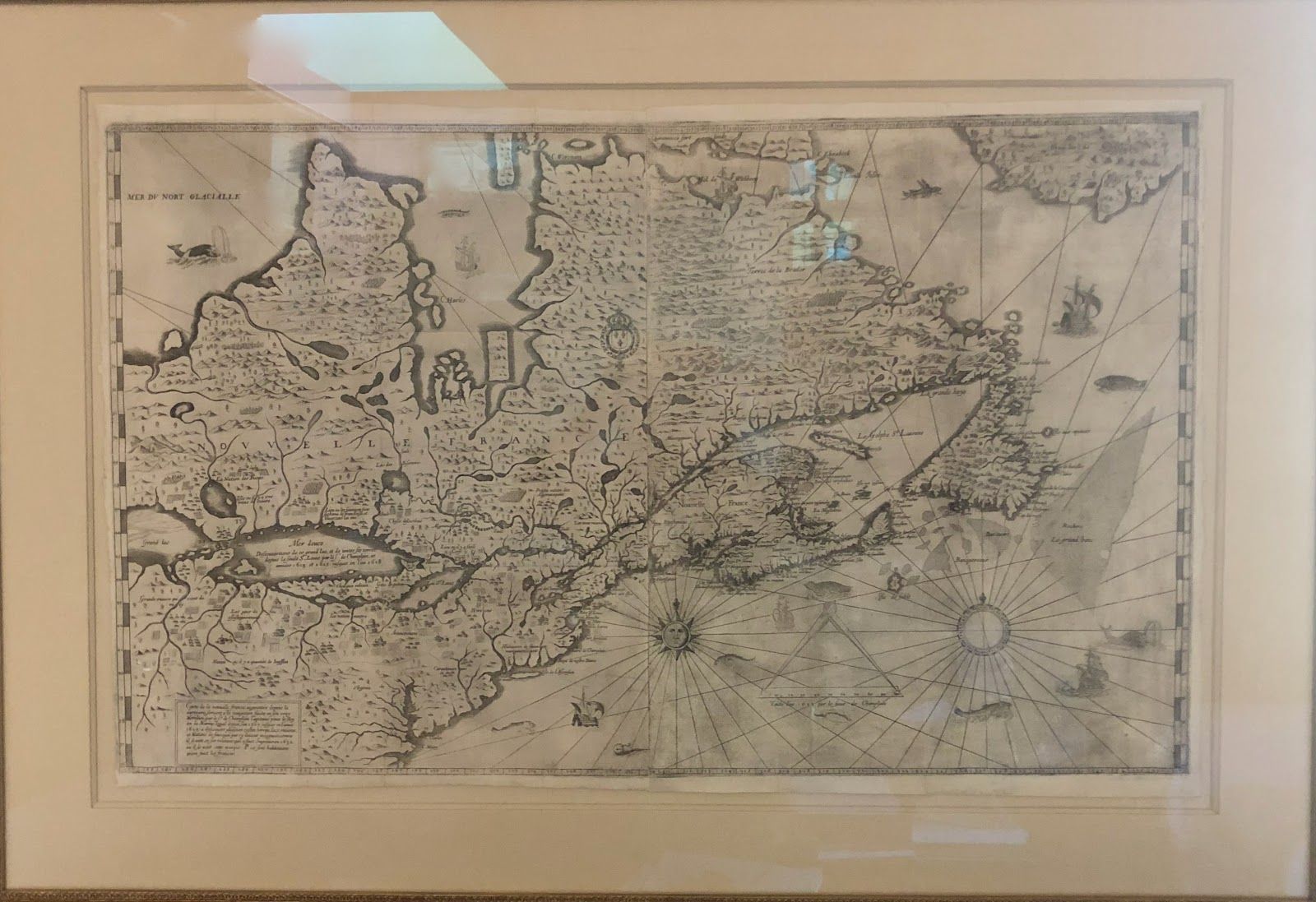
CHAMPLAIN, Samuel de (c. 1567-1635). Carte de la nouvelle France" from Les Voyages de la Nouvelle France Occidentale, dicte Canada. Paris: 1632.Copper-plate engraving on two sheets (20 ½ x 34 in.; 52 x 86.3 cm.).CHAMPLAIN'S FINAL MAP OF NEW FRANCE AND A LANDMARK IN THE MAPPINGOF THE GREAT LAKES, NEW ENGLAND AND CANADA. Like his map of 1613, it was published to accompany an account of Champlain's voyages in New France - in this case the most complete version, detailing his discoveries through 1629. It is extremely rare. This map is of signal importance not only for the comprehensive summary it provides of French knowledge of Acadia and the St. Lawrence valley at the time, but above all because of its representation of the Great Lakes. For the first time all of them except Lake Michigan appear. "Lac St. Louis" is Lake Ontario, leading up to "a fall of water at the end of the Falls of St. Louis, very high, where many kinds of fish are stunned in descending". A rudimentary Lake Erie is followed by a more recognizable "Mer douce," now known as Lake Huron, the “freshwater sea." "Grand Lac," Lake Superior, which Champlain never actually saw, is here depicted for the first time in recognizable form on a map. The map contains far greater detail and spans a much greater area than any of Champlain's earlier attempts, extending as far south as the Virginia colonies. The Hudson River appears as the "Riviere des trettes," and Long Island is “Isle de l'Ascension." An illustration of a church serves to indicate the Dutch presence in the region, and is considered the first delineation of present-day New York City on a printed map. Oddly, perhaps, there is no reference to the English in New England (perhaps Champlain thought his map would better express French domination of the region if he avoided acknowledging the British stronghold in the area). Champlain depicts a huge sea to the north that forms part of the hypothetical Northwest Passage, and with the coat of arms of Louis XIII he lays French claim to the vast expanse of northern Canada. "Carte de la Nouvelle France," like Champlain's map of1613, provided invaluable knowledge about unknown areas, and remains a cornerstone document in American and Canadian cartography. REFERENCES: Conrad E. Heidenreich & Edward H. Dahl, "The French Mapping of North America in the Seventeenth Century," The Map Collector (June, 1982): 5; Philip D. Burden, The Mapping of North America: A List of Printed Maps 1511-1670 (Rickmansworth, 1996), 294-295. Bookseller Inventory # 000481Price: $750,000.
