from: Encounters and Empires: Africa, America, and the Early Modern World
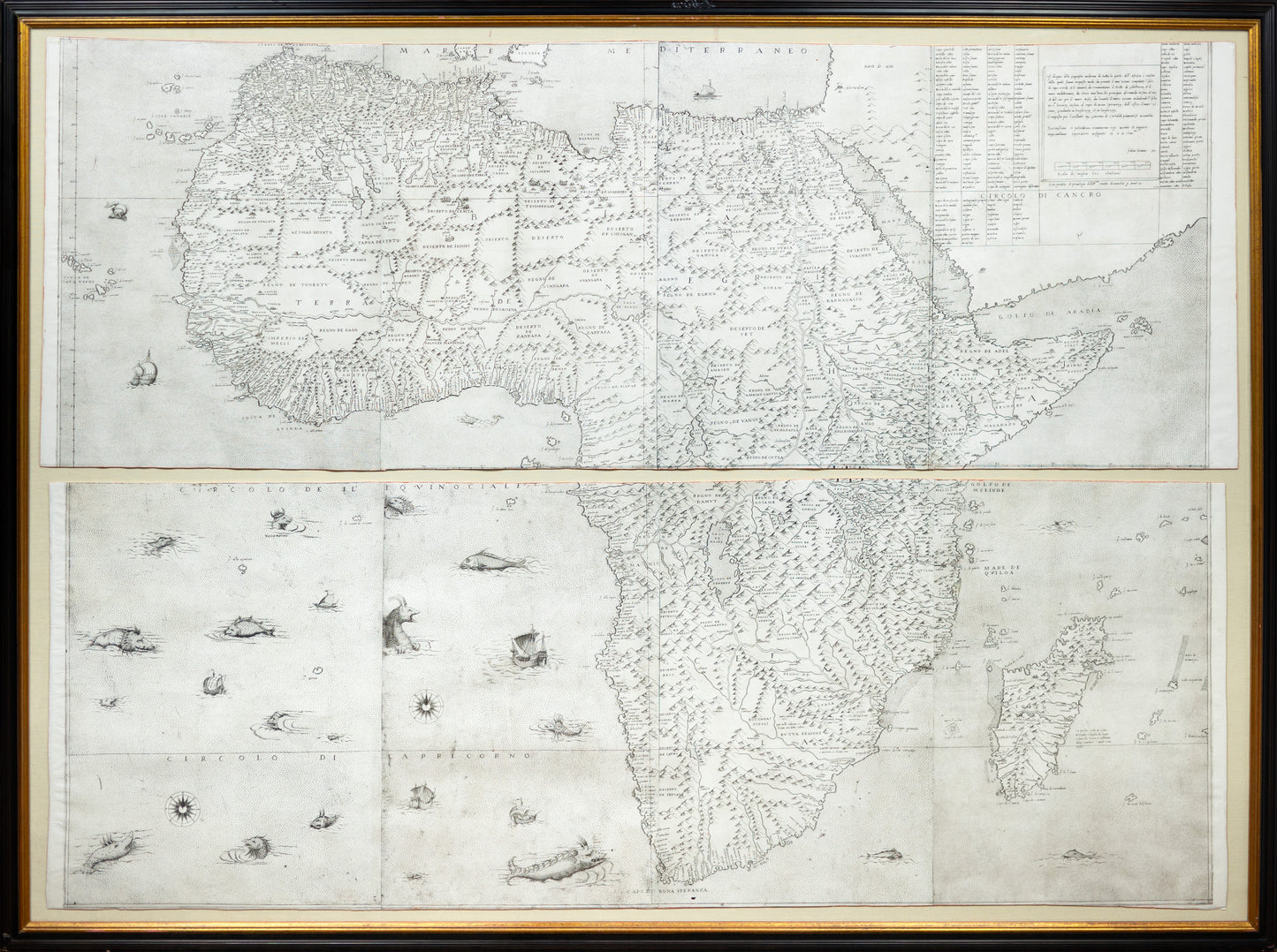
Giacomo Gastaldi, Il disegno della geografia moderna de tutta la parte dell’ Africa (Venice, 1564)
Giacomo Gastaldi, Il disegno della geografia moderna de tutta la parte dell’ Africa (Venice, 1564)
Couldn't load pickup availability
Giacomo Gastaldi (ca. 1500–1566)
Il disegno della geografia moderna de tutta la parte dell’Africa
Venice: Fabio Licinio, 1564
First edition, first state
“Probably the single most important and influential map of Africa of the sixteenth century” (Betz)
Giacomo Gastaldi’s large-scale wall map of Africa, engraved and published by Fabio Licinio, is a cornerstone of Renaissance cartography. It synthesizes classical geography with information from sixteenth-century exploration and travel accounts, influencing many later maps of the continent.
The map reflects a transitional moment in European geographic knowledge, blending inherited sources with emerging empirical observation. Its scale, detail, and wide impact make it one of the most consequential printed representations of Africa from the sixteenth century.
- Medium: Engraved map on 8 sheets, joined
- Place and date: Venice, 1564
This monumental wall map belongs to the early visual framework through which Europe came to understand, categorize, and ultimately dominate the African continent. Produced at a moment when Portuguese maritime networks were firmly established along Africa’s coasts, the map reflects the geographic knowledge that underpinned expanding systems of trade, extraction, and forced human movement. Rivers, ports, and inland routes are emphasized in ways aligned with commercial and navigational priorities, corresponding to the same corridors used for gold, ivory, and enslaved Africans. While the map does not depict the slave trade explicitly, it functioned within the intellectual and economic infrastructure that enabled transatlantic slavery, transforming African geographies into legible, tradable spaces for European powers. In this sense, the map stands not only as a landmark of Renaissance cartography, but also as a document of the emerging colonial worldview that reshaped Africa and the Atlantic world in the sixteenth century.
Giacomo Gastaldi’s wall map of Africa is widely regarded as the most influential printed representation of the continent produced during the sixteenth century. Engraved and published in Venice in 1564 by his close collaborator Fabio Licinio, the map synthesizes classical geographic traditions with the rapidly expanding body of information derived from Portuguese exploration and Renaissance travel literature. Its scale, ambition, and clarity mark a decisive moment in the European visualization of Africa.
Although issued after Paolo Forlani’s African maps of 1562 and 1563, scholarship suggests that Gastaldi completed the design several years earlier. Bifolco and Ronca argue that publication was deliberately delayed until 1564 in order to dedicate the map to Maximilian II of Habsburg, newly proclaimed King of the Holy Roman Empire that year. The map thus appears at a precise historical moment when geographic knowledge, political authority, and imperial ambition converged.
The map corrects and expands upon Gastaldi’s own smaller Africa map of 1554. Most notably, the southern tip of Africa is shifted significantly westward, correcting a long-standing eastward distortion found in earlier cartography. The hydrography of the continent is rendered with unprecedented complexity. The Zembere River rises from a western Ptolemaic lake, crosses a mountainous interior, and divides into the Zambezi and Limpopo before reaching the southeastern coast. In southern Africa, the legendary gold-bearing region is anchored by the twin cities of Zimbro and Simbaoe, an early cartographic reference to Great Zimbabwe. In West Africa, the Niger River flows westward from the Lago del Niger toward the Atlantic, passing through interior lakes evocative of Lake Chad and the Lago Guber.
Gastaldi drew upon an exceptional range of sources. These included his own maps prepared for the Geografia di Tolomeo (1548), the painted wall map executed for the Palazzo Ducale in Venice in 1549, and his work for Ramusio’s Navigationi et Viaggi, first published in 1550. Additional information was derived from travel accounts by Francisco Álvares, João de Barros, and Duarte Barbosa, particularly for the African interior and eastern coast. According to Sims, Gastaldi also relied extensively on Portuguese nautical charts, lending the map a level of empirical authority unmatched by earlier printed representations.
The influence of this map was immediate and enduring. It served as the primary model for later depictions of Africa by Gerard de Jode, Giovanni Francesco Camocio, Donato Bertelli, and Cornelis de Jode. For this reason, Gastaldi’s wall map is widely regarded as the definitive Renaissance image of the African continent.
Bifolco and Ronca record nineteen known examples of the first state, seven of which, like the present example, lack the non-cartographic lower-left sheet. The second state, issued in 1565, is distinguished by the addition of three cartouches and a revised publication date.
References: Betz 9; Bifolco–Ronca I.93 (pp. 430–433)