from: Early World Maps
SEBASTIAN MUNSTER (1488-1552) and HANS HOLBEIN, the Younger (1497-1543). Typus Cosmographicus Universalis. Basel: Johannes Hervagius, 1532
SEBASTIAN MUNSTER (1488-1552) and HANS HOLBEIN, the Younger (1497-1543). Typus Cosmographicus Universalis. Basel: Johannes Hervagius, 1532
Couldn't load pickup availability
Sebastian MUNSTER (1488-1522) & Hans HOLBEIN THE YOUNGER (1497-1543)
Typus Cosmographicus Universalis
Basel, 1532
First edition, published in Johann Huttich and Simon Grynaeus’ “Novus orbis regionum ac insularum veteribus incogntarum”
2 sheets joined (16” x 22 4/8”, full margins)
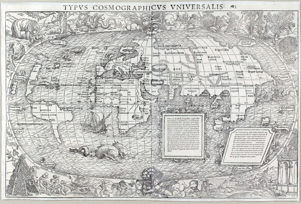
Fine woodcut world map on an oval projection, the cartography ascribed to prominent cartographer Sebastian Münster and the engraving to the celebrated German artist Hans Holbein the Younger, notably with an angel at each pole with a crank to turn the world on its axis, with sea monsters adorning the waves of the oceans, exotic animals and landscape views with curious classical architectural structures around the margins, along with less benign scenes depicting acts of cannibalism and animal sacrifice.
Huttich and Grynaeus’ “Novus Orbis Regionum...” was published in Basel as well as in Paris. The Basel edition was accompanied by a different map than the one used in Paris: in this case, a woodcut map utilizing an oval projection. The cartography of the map has been ascribed to the prominent cartographer Sebastian Münster (1488-1552). Munster was a cosmographer, cartographer and a Hebrew scholar who taught at the University of Basel. He is best known for his 1544 book “Cosmographica” which was both a learned treatise on geography and a best seller. However, in 1532 he contributed introductory comments to Huttich and Grynaeus’ book, and most scholars believe he also drew the accompanying map.
The map itself was antiquated when published, and was far inferior to the Fine map used for the Paris publication. It did echo Waldseemuller’s separation of the Americas from Asia, but lacked much of the detail of the region found in Fine’s map. Its treatment of Asia was also behind the most recent discoveries, particularly by the Portuguese. Neither the map nor Munster’s comments in the book reflect Magellan’s circumnavigation of the globe, or the existence of a southern continent. Japan (“Zipangri”) is positioned close to North America (demoninated “Cuba”). In these and other respects the map is an anachronism.
The map is famous and sought after however for its decoration, which was likely the work of Hans Holbein the Younger (1497-1593). The map and the margins outside the oval projection are filled with scenes, real and fanciful, including sea monsters adorning the waves of the oceans, exotic animals and landscape views with curious classical architectural structures around the margins, along with less benign scenes depicting acts of cannibalism and animal sacrifice. Most notable are the two angels, one at each pole, turning cranks that will rotate the earth. This is in line with Copernicus’ heliocentric model, which was not published until 1543. Thus, this map may be the first published reference to the theory, which was at the time being discussed widely (though quietly) among humanist scholars throughout Europe.
References: Shirley 67. Lloyd Arnold Brown, The World Encompassed, exh. cat. (Baltimore, 1952), n. 65; Harrisse 198-199.
