

FAIRFAX DOCUMENTS, 3 Manuscript Maps delineating the Land of Lord Thomas sixth Lord Fairfax of Cameron (1693-1781)
FAIRFAX DOCUMENTS, 3 Manuscript Maps delineating the Land of Lord Thomas sixth Lord Fairfax of Cameron (1693-1781)
Couldn't load pickup availability
FAIRFAX DOCUMENTS, 3 Manuscript Maps delineating the Land of Lord Thomas sixth Lord Fairfax of Cameron (1693-1781).
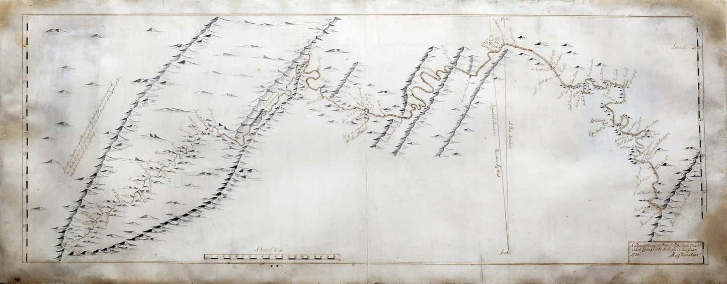
1. WINSLOW, Benjamin.
A Plan of the Upper Part of Potomack River called Cohongorooto, survey'd in the Year 1736.
Titled and signed "Benj. Winslow" lower right-hand corner.
Pen and ink and ink wash on paper.
18 1/2" x 45" sheet, 28" x 55" framed.
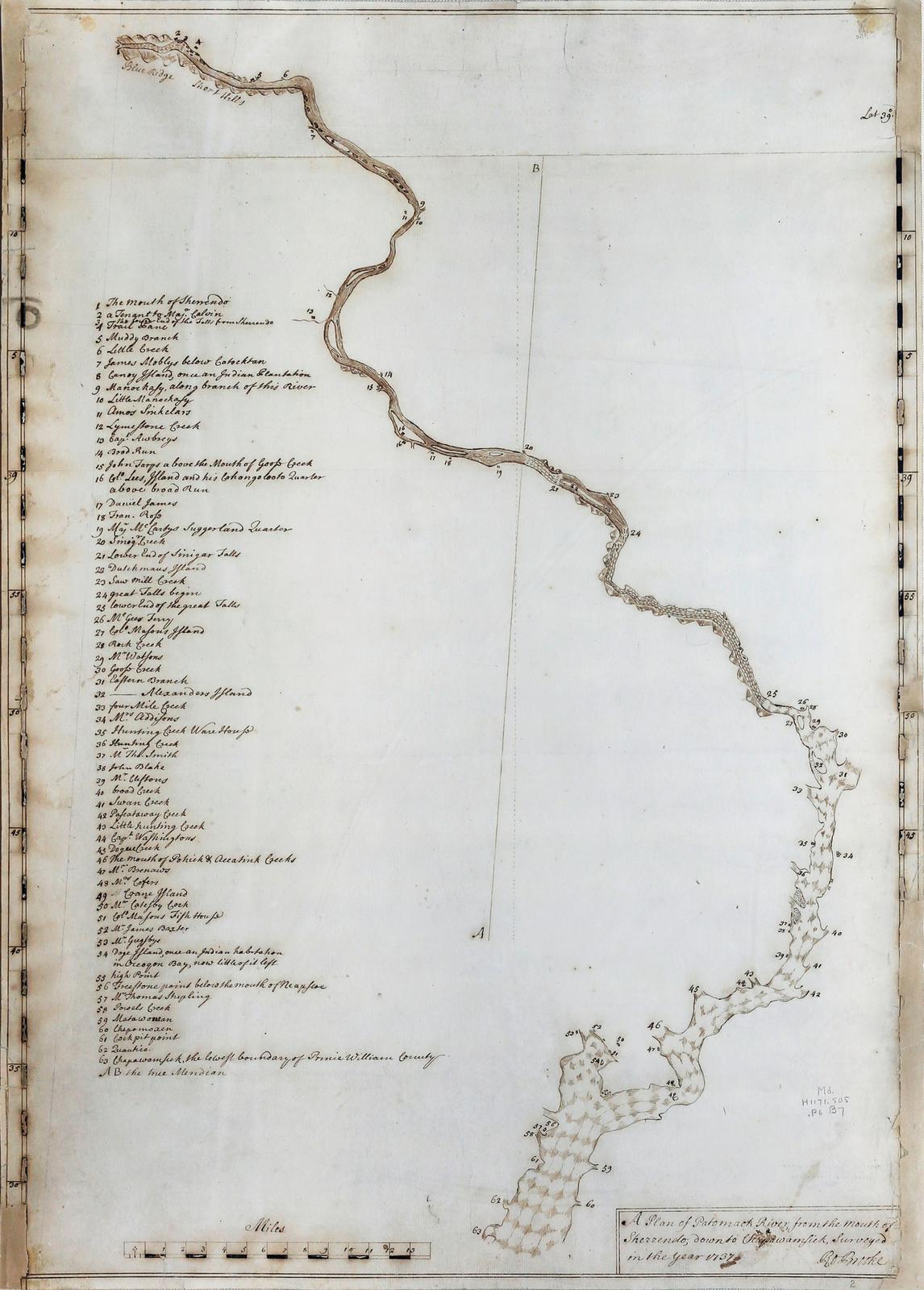
2. BROOKE, Robert.
A Plan of Potomack River, from the Mouth of Sherrendo, down to Chapawamsick, surveyed in the year 1737.
Titled and signed "Ro. Brooke" lower right-hand corner.
Pen and ink on paper.
25 1/2" x 18" sheet, 35" x 27" framed.
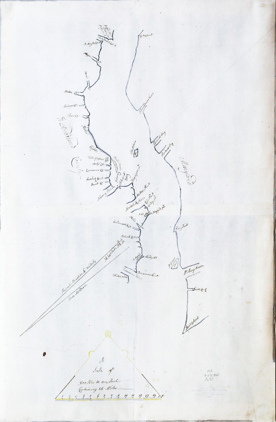
3. THOMAS, James (1666-1742).
A fine manuscript map of the Potomac River as it runs through Westmoreland County in Virginia. [1737].
Pen and ink and ink wash on paper.
24 1/4" x 15 3/4" sheet, 33" x 25" framed.
THE FIRST ACCURATE AND DETAILED SURVEY OF THE POTOMAC RIVER, which ILLUSTRATES FOR THE FIRST TIME THE ACCURATE POSITION OF THE HEAD-WATERS OF THE POTOMAC TO DETERMINE BOUNDS TO SIR THOMAS FAIRFAX'S CLAIM.
_____________________________
John Rennie Short description: "Colonial America and the early republic were constituted around property, territory, and land. The land of the indigenous people was bought, annexed or stolen and turned into property. Once land is commercialized and commodified it needs to be accurately measured. English surveying and mapmaking methods developed during the dissolution of the monasteries in the 1530 when large amounts of formerly Church land came onto the onto the private market were employed and refined in North America. Surveying was an important profession. George Washington first career was as a land surveyor. Thomas Jefferson's grandfather and father were both surveyors. The commodification of land required its accurate measurement and careful cartographic representation. Surveying and mapping were vital to making legal claims to land, settling land disputes and authorizing ownership."
_____________________________
Three unique original manuscript maps, rich in detail and accuracy, are all that survives of the original surveyor's charts which became the source material for the larger manuscript maps composed by John Warner and William Mayo to establish the bounds of Sir Thomas Fairfax's claim to the Northern Neck area of the Potomac River in Virginia. These maps were subsequently published as the celebrated "Fairfax" map of Virginia: The Courses of the Rivers Rappahannock and Potowmack in Virginia, as surveyed according to order in the years 1736 & 1737 (London: ca 1737), and Map of the Northern Neck in Virginia by William Mayo (London 1745), which were the most accurate maps of Virginia until the publication of Fry and Jefferson's "A Map of the inhabited part of Virginia containing the whole Province of Maryland with part of Pensilvania, New Jersey and North Carolina" (1753).
"THE SURVEY MARKED AN EPOCH IN GEOGRAPHIC INVESTIGATION OF AMERICA BY THE ENGLISH. NO EXPEDITION DOWN TO THIS TIME SEEMS TO HAVE ACCOMPLISHED AT ONCE SO EXACT AND SO EXTENDED AN EXAMINATION INTO THE INTERIOR" (Foster).
Thomas Culpeper (1635 - 1689), colonial governor of Virginia and second Lord Culpeper was given a share in the proprietorship of the Northern Neck of Virginia, consisting of more than five million acres, under a patent issued in 1649 and reconfirmed in 1669. Through dereliction of his duties as Governor, King Charles II forced Culpeper to sell to the Crown all his proprietary rights in Virginia, except for the Northern Neck lands, in return for a lump sum payment of $700 and an annual pension of $600 for twenty-one years. However the patent for this remaining property was ambiguous: "all that intire tract... bounded by and within the first Heads or Springs of the Rivers... Rappahannock, &... Potomack & by the Courses of the said Rivers from their said first Heads or Springs ... and the Bay of Chesapeyock...". Unfortunately the uncertainty of the exact whereabouts of the first heads of each river, ultimately lead to a boundary dispute when at the insistence of Governor Alexander Spotswood of Virginia, settlement of the southern Piedmont began.
Thomas Fairfax, sixth Lord Fairfax of Cameron (1693-1781) had inherited the Northern Neck estates from his mother Catherine Culpeper in 1719, but had never lived there. On several occasions, the Virginia Assembly questioned both the legality of the grant and the precise boundaries it encompassed. The primary issue was the actual location of the headwaters of the rivers.
Threatened with a further reduction in his land, Thomas Fairfax eventually arrived in Virginia in 1735, and immediately petitioned the King for a joint commission to survey and fix the boundaries of his enormous estate. The local Governor Sir William Gooch, appointed representatives for the Crown. As a result two surveys were instigated from different directions to the previously unknown source of the Potomac River. Both parties met at Fredericksburg on September 25 in 1736 and it was decided that the surveyors for the crown should be William Mayo and Robert Brooke, and for Fairfax Benjamin Winslow and John Savage.
While the victory at the time was Fairfax's claims being given full recognition by the crown, the most important product of these efforts were the most important early maps of this area in American History. From these preliminary charts, pivotal maps such as A Map of Pensilvania, New-Jersey, New York, and the three Delaware Countries (1749) by Lewis Evans, Joshua Fry and Peter Jefferson's A Map of the inhabited part of Virginia.. (1751).
WINSLOW, Benjamin. A Plan of the Upper Part of Potomack River called Cohongorooto, survey'd in the Year 1736. Titled and signed "Benj. Winslow" lower right-hand corner. Two sheets joined (16 x 42 5/8 inches to the neatline, 18 4/8 x 45 4/8 to sheet edge). A fine manuscript map drawn in pen and ink with ink wash, featuring the course of the Potomack River from the "Head Spring" at the summit of the Alleghenies to its junction with the Shenandoah River in the Blue Mountains; showing its islands, tributaries, abutting plantations, former Shawnee settlements, "colemines", and the mountains of the Blue Ridge in beautiful detail (some oxidization, edges chipped and expertly renewed with minor loss to the neatline lower right).
BROOKE, Robert. A Plan of Potomack River, from the Mouth of Sherrendo, down to Chapawamsick, surveyed in the year 1737. Titled and signed "Ro. Brooke" lower right-hand corner. Two sheets joined (25 x 17 6/8 inches to the neatline, 25 4/8 x 18 inches to sheet edges).A fine manuscript map drawn in pen and ink. Accurately showing the course of the river, complete with rapids and swamps, within the river boundary of Prince William County, recording 63 locations, tenants, creeks, and Piscattaway settlements. The legend along the lefthand side lists the names of settlers and sites including "Cpt.n. WASHINGTON'S" land, the future site of Mount Vernon, and home of George Washington from 1735-1739, and then from 1754; and the future sites of Georgetown and Alexandria, now the site of the Nation's Capital.WASHINGTON D.C. (edges chipped and expertly renewed affecting areas of the neatline).
[THOMAS, James, (1666- 1742)]. A fine manuscript map of the Potomac River as it runs through Westmoreland County in Virginia. [1737]. Two sheets joined (24 2/8 x 15 6/8 inches to the neatline). A fine manuscript map drawn in pen and ink and ink wash, decorated with a bar scale of miles surmounted by a representation of a pair of dividers in yellow and gray wash. Accurately showing the course of the river from the western boundary of Westmoreland at Cedar's Point, through the land owned by the Monroe, Mattox, Bridges, Pope, and the Washington families, and importantly GEORGE WASHINGTON'S BIRTHPLACE, to Yeocomoco River in the east which marks the boundary with Northumberland County (lower right-hand corner expertly renewed affecting the neatline). THE FIRST ACCURATE AND DETAILED SURVEY OF THE POTOMAC RIVER
Three unique manuscript maps, and all that survives of the original surveyor's charts which became the source material for the celebrated "Fairfax" map of Virginia: "THE COURSES OF THE RIVERS RAPPAHANNOCK AND POTOWMACK IN VIRGINIA, AS SURVEYED ACCORDING TO ORDER IN THE YEARS 1736 & 1737" [London: 1747], the most accurate map of Virginia until the publication of Fry and Jefferson's "A Map of the inhabited part of Virginia containing the whole Province of Maryland with part of Pensilvania, New Jersey and North Carolina" (1753). "THE SURVEY MARKED AN EPOCH IN GEOGRAPHIC INVESTIGATION OF AMERICA BY THE ENGLISH. NO EXPEDITION DOWN TO THIS TIME SEEMS TO HAVE ACCOMPLISHED AT ONCE SO EXACT AND SO EXTENDED AN EXAMINATION INTO THE INTERIOR" (Foster). Kate Hunter 2011. Bookseller Inventory # 72lib120